Areas:
Bent Creek Experimental Forest:
Bent Creek Experimental Forest covers over 6,000 acres with miles of hiking and mountain biking trails surrounding Lake Powhatan.
Cradle of Forestry:
Cradle of Forestry marks the birthplace of forestry in America and has exhibits and trails to learn about forestry.
Davidson River:
Davidson River is a major tributary of French Broad River. The Davidson River area is located just north of Brevard and contains numerous waterfalls.
Graveyard Fields:
Graveyard Fields is a beautiful high altitude open area nestled between the Blue Ridge Parkway and Shining Rock Wilderness with hiking, primitive camping and waterfalls.
Horsepasture River:
Horsepasture Wild & Scenic River flows over 4 miles from NC-281 through the forest and into Lake Jocassee in South Carolina. However, the only legal access is through Gorges State Park.
Middle Prong Wilderness:
Middle Prong Wilderness protects the Middle Prong of West Fork Pigeon River as flows down from Richland Balsam.
Mills River:
Mills River is a major tributary of French Broad River. National Forest land surrounding the river includes campgrounds, hiking trails and numerous waterfalls.
North Carolina Arboretum
The North Carolina Arboretum is a public garden adjacent to Bent Creek Forest.
Thompson River
The Thompson River is one of the four major rivers that flow into Lake Jocassee. Numerous waterfalls are found on the river and its tributaries.
Waterfalls:
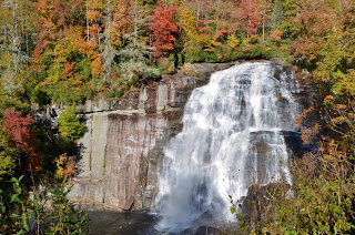
The Pisgah Ranger District has one of the highest densities of waterfalls anywhere in the world.
- Avery Creek Falls
- Avery Creek Upper Falls
- Barnett Branch Trail Falls
- Berry Branch Falls
- Big Beartrap Falls
- Big Bearwallow Falls
- Bubbling Spring Branch Cascades
- Bubbling Spring Branch Lower Falls
- Bubbling Spring Branch Upper Falls
- Buckeye Falls
- Caney Bottom Falls
- Catheys Creek Falls
- Cedar Rock Falls
- Cedar Rock Upper Falls
- Clawhammer Falls
- Cody Falls
- Corbin Creek Falls
- Courthouse Falls
- Cove Creek Falls
- Discovery Falls
- Double Branch Falls
- Drift Falls
- Gemini Falls
- Grogan Creek Falls
- Hidden Falls
- Hidden Dome Falls
- High Falls (Thompson River)
- John Neal Falls
- Kuykendall Falls
- Laughing Falls
- Laurel Fork Falls
- Laurel Fork Lower Falls
- Laurie Falls
- Lemon Falls
- Little Beartrap Falls
- Little Bird Falls
- Little Moore Cove Falls
- Little Wildcat Falls
- Log Hollow Falls
- Log Hollow Upper Falls
- Logging Road Falls
- Long Branch Falls
- Looking Glass Falls
- Middle Prong Falls
- Moore Cove Falls
- Mount Hardy Falls
- Rainbow Falls
- Reid Branch Falls
- Rockhouse Creek Lower Falls
- Sam Branch Falls
- Sam Branch Lower Falls
- Second Falls
- Simon Falls
- Skinny Dip Falls
- Slick Rock Falls
- Slick Rock Lower Falls
- Sliding Rock
- Stairway Falls
- Sunburst Falls
- Toms Spring Falls
- Toms Spring Upper Falls
- Turtleback Falls
- Twin Falls
- Twin Boulder Falls
- Upper Falls
- Wash Hollow Falls
- Wildcat Falls
- Wildcat Lower Falls
- Yellowstone Falls
External Links:
US Forest Service website: https://www.fs.usda.gov/recarea/nfsnc/recarea/?recid=48116


No comments:
Post a Comment