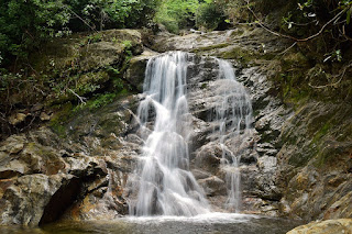
Lower Sam Branch Falls is a 50-foot waterfall on Sam Branch, a tributary of West Fork Pigeon River, in Haywood County, North Carolina. The waterfall is located in Pisgah National Forest near Shining Rock Wilderness.
Hike Length: 0.5 miles
Estimated Time: < 1 hour
Difficulty: Easy to Moderate
Location: Pisgah Ranger District of Pisgah National Forest
Trail Users: Hiking only
Dogs: Yes
Features: Waterfalls (1+)
Crowds: Moderate
Warnings: The rocks around the waterfalls are very slippery.
Trailhead GPS: 35.33962,-82.90110
Waterfall GPS: 35.34104,-82.89801
Waterfall GPS: 35.34104,-82.89801
Directions:
From Brevard, head west on US-64 for about nine miles and turn right on NC-215 north. Drive about 21.2 miles on NC-215 N to a pull-off on the right side of the road in a sharp left-hand turn. The pull-off is about 4 miles north of the Blue Ridge Parkway.
Map:
Hike Description:
From the parking, take a steep path that heads up the bank to an old logging grade. Turn left and follow the path for 0.25 miles to the end at the middle of Lower Sam Branch Falls.
Cross the creek here carefully here as it's above the lower portion of the falls.
Once across, look for a path to the left that heads down to the base of the falls. The path going straight leads to Wash Hollow Falls. Turn left instead and go down to the base.
From here, cross again and climb up to the main trail and turn right to return to the parking area. Here's a video of the falls.
Blog Entries:
04-Jul-2022: Independence Day at Sam Branch


No comments:
Post a Comment