
Map:
Trails:
Art Loeb Trail (#146):
Art Loeb Trail is a 30.1-mile that leads from the Davidson River Campground to near Cold Mountain in Shining Rock Wilderness. About 17 miles of the trail are in the Davidson River Area.

Butter Gap Trail (#123):
Length: 3.1 miles
Difficulty: Moderate
Blaze: Blue
Butter Gap Trail starts from Cat Gap Loop Trail near the confluence of Grogan and Cedar Rock Creek. The trail leads through Picklesimer Fields and follows Grogan Creek upstream passing Grogan Creek Falls. The trail ends at Butter Gap at the intersection with Art Loeb Trail.

Caney Bottom Trail (#361)
Length: 1.8 miles
Difficulty: Moderate
Blaze: Blue
Caney Bottom Trail leads from Cove Creek Group Camp and follows its namesake upstream, intersecting with Cove Creek Trail.

Cemetery Loop Trail (#341):
Length: 1.2 miles
Difficulty: Easy
Blaze: Yellow
Cemetery Loop Trail starts from the end of gated FR-475D and leads past the McCall Cemetery with graves dating from the 19th century. The trail ends at Long Branch Trail.

Cove Creek Trail (#340)
Length: 2.6 miles
Difficulty: Easy
Blaze: Yellow
Cove Creek Trail splits from Caney Bottom Trail at Cove Creek Group Camp and follows its namesake upstream. A short spur leads to Cove Creek Falls. The trail intersects the other end of Caney Bottom Trail and terminates at FR-225.

Daniel Ridge Loop Trail (#105):
Length: 4 miles
Difficulty: Moderate
Blaze: Red
Trailhead GPS: 35.28462,-82.82874
Trailhead GPS: 35.28462,-82.82874
Daniel Ridge Loop Trail starts from the parking on FR-475. FR-5046 leads from the parking area across a bridge over Davidson River and the trail starts right after the bridge to the left. It climbs up along Davidson River passing several scenic cascades. After Daniel Ridge Creek, the trail begins following Right Fork upstream. After a mile, Farlow Gap Trail splits to the left. Daniel Ridge Loop goes right and passes through forest and wildlife clearings. The trail then descends along Toms Spring Branch and ends back at FR-5046 next to Toms Spring Falls. Turn right to return to the parking.


Estatoe Trail (#111):
Length: 1.5 miles
Difficulty: Easy
Blaze: None
Estatoe starts from the Art Loeb Trailhead at Davidson River Campground and follows Davidson River downstream to US-64.

Long Branch Trail (#116):
Length: 2.7 miles
Difficulty: Moderate
Blaze: Orange
Long Branch Trail starts from a trailhead along FR-475 and leads along Long Branch. Cemetery Loop Trail splits off to the left. After following its namesake, the trail descends and crosses FR-5095 (Searcy Creek Road) and then follows Searcy Creek downstream, ending at Butter Gap Trail.

Waterfalls:
Caney Bottom Falls
Caney Bottom Falls is a sliding waterfall along Caney Bottom Trail.

Catheys Creek Falls
Catheys Creek Falls is along Catheys Creek Road near Kuykendall Group Campground.

Cedar Rock Falls:
Cedar Rock Falls is a 20-foot waterfall on its namesake creek near the Pisgah Center for Wildlife Education.

Cedar Rock Upper Falls:
Upper Cedar Rock Falls is a small waterfall at a campsite just above the main falls.

Cove Creek Falls
Cove Creek Falls is a scenic waterfall near Cove Creek Group Camp.

Discovery Falls:
Discovery Falls is a 50-foot waterfall on a tributary of Log Hollow Branch.

Gemini Falls:
Gemini Falls is a nice 80-foot waterfall on a tributary of Laurel Fork.

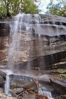
Grogan Creek Falls:
Grogan Creek Falls is a scenic 20-foot waterfall near the fish hatchery.

Kuykendall Falls:
Kuykendall Falls is a remote waterfall that requires a long hike on a gated road.

Laurel Fork Falls:
Laurel Fork Falls is a scenic 50-foot waterfall but there is no trail and its difficult to reach.

Laurel Fork Lower Falls:
Lower Laurel Fork Falls is a 25-foot waterfall on its namesake.

Log Hollow Falls:
Log Hollow Falls is a scenic 30-foot waterfall just off a gated logging road.

Log Hollow Upper Falls:
Upper Log Hollow Falls is another waterfall just upstream of the main waterfall.

Logging Road Falls:
Logging Road Falls is on a tributary of Log Hollow Branch.

Long Branch Falls:
Long Branch Falls is a 25-foot waterfall accessed from a gated forest road.

Rockhouse Creek Lower Falls:
Lower Rockhouse Creek Falls is a roadside waterfall near the Pisgah Center for Wildlife Education.

Slick Rock Falls:
Slick Rock Falls is an easy to reach waterfall along FR-475B.
Slick Rock Lower Falls:
Lower Slick Rock Falls is just above the confluence with Rockhouse Creek.

Sliding Rock:
Sliding Rock is a natural waterslide along Looking Glass Creek.

Toms Spring Falls:
Toms Spring Falls, also called Jackson Falls or Daniel Ridge Falls, is located right along FR-5046 and can be accessed from Daniel Ridge Loop Trail.


Toms Spring Upper Falls:
There is an Upper Falls on Toms Spring Branch that can be accessed from FR-5046.


Twin Boulder Falls:
Twin Boulder Falls is a 60-foot waterfall on Right Fork of Davidson River.
Wildlife:
Mountain laurel (Kalmia latifolia) is common on the mountain slopes and typically flowers in late May to early June.

Flame azaleas (Rhododendron calendulaceum) produce brilliant orange-red flowers in late spring.

Fairy wand (Chamaelirium luteum) produces a long, white spike flower.

Red trillium (Trillium erectum) are also called Stinking Benjamin, because their carrion-scented flowers are pollinated by flies.

Jack in the pulpit (Arisaema triphyllum) have interesting flowers where the spathe or "pulpit" covers the spadix or "jack".

Butterfly bush (Buddleja davidii)

Common funnels (Infundibulicybe gibba)

A snail crawling on rocks along Davidson River.

Blog Entries:
31-Aug-2025: Cove Creek Hike
31-Dec-2022: Art Loeb Long Branch Loop
30-Dec-2022: Art Loeb to Cedar Rock Mountain
30-May-2021: Fowler Creek Falls
14-Jun-2020: Twin Boulder Falls
21-May-2020: Daniel Ridge Hike
04-Aug-2018: Flooded Falls
27-Apr-2018: Laurel Fork Waterfalls
27-Aug-2017: Kuykendall Falls
25-Aug-2017: Birthday Waterfalls in Pisgah Forest
09-Oct-2016: Kiesee and Hooker Falls
06-Aug-2016: Shining Rock & Courthouse Falls
25-May-2015: Toms Spring & Shuck Ridge Creek Falls
24-May-2015: Pisgah Forest & Shining Rock Waterfalls
22-Feb-2015: Courthouse Creek in the Snow
23-Oct-2014: Log Hollow and Eastatoe Falls
18-Oct-2014: Pisgah Forest Waterfalls
29-Jun-2014: Shuck Ridge Creek Falls
28-Jun-2014: Waterfalls in the Rain
28-Jul-2013: DuPont Forest - Bridal Veil Falls
16-Mar-2013: Hidden Waterfalls in Gorges
No comments:
Post a Comment