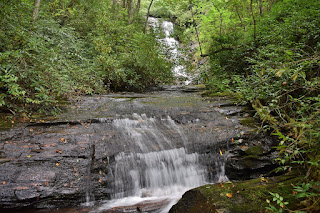
Kuykendall Falls is an 40-foot
waterfall on Kuykendall Creek in Transylvania County,
North Carolina. The waterfall is located in the
Davidson River area of the
Pisgah Ranger District of
Pisgah National Forest.
Hike Length: 9.2 miles
Estimated Time: 4 to 5 hours
Difficulty: Difficult
Location:
Davidson River (
Pisgah Ranger District of
Pisgah National Forest)
Trail Users: Hiking
Dogs: Must be on a leash
Features: Waterfalls (1)
Crowds: Low
Warnings: The rocks around the waterfalls are very slippery. The bushwhack down to the falls is steep and you'll have to scramble up the creek for a good view.
Trailhead GPS: 35.22781,-82.80789
Waterfall GPS: 35.24463,-82.78777
Directions:
From Brevard, head west on US-64 for about 3 miles and turn right at Catheys Creek Road. Make an immediate left to stay on Catheys Creek Road. Drive a total of 3.1 miles on this road, which becomes gravel and enters the forest to become Forest Road 471. Turn right at gated FR-5361 and park without blocking the gate.
Map:
Hike Description:
Hike down FR-5361 for 4.5 miles. It's hard to judge this distance while hiking, but there are a couple landmarks. At around 2.2 miles, FR-5361A comes in from the right. At around 3 miles, FR-5361B splits off to the right at a clearing. At about 3.8 miles you'll come to another clearing with views of Cedar Rock Mountain. In another half a mile or so, you'll cross a drainage and then make a sharp left turn around a ridge. At this point you want to get off the road and bushwhack down towards the sound of the waterfall. It's really steep, but pretty open so you won't have to wade through rhododendron until you get down to creek level. You should come out at Kuykendall Creek just upstream of the confluence with Hickory Mountain Branch. The waterfall is visible upstream.
Scramble up the creek for a good view of the falls.
Blog Entries:


No comments:
Post a Comment