
Hike Length: 5.2 miles
Estimated Time: 2 to 3 hours
Difficulty: Moderate
Location: Middle Prong Wilderness (Pisgah Ranger District of Pisgah National Forest)
Trail Users: Hiking only
Dogs: Yes
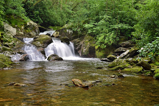
Features: Waterfalls (1+)
Crowds: Low
Warnings: The rocks around the waterfalls are very slippery.
Trailhead GPS: 35.37057,-82.93944
Waterfall GPS: 35.34504,-82.94479
Waterfall GPS: 35.34504,-82.94479
Directions:
Head south on NC-215 from Canton for about 13 miles, passing Lake Logan. Just past Sunburst Campground, turn right into Forest Road 97. If coming from the Blue Ridge Parkway, go north on NC-215 for about 8.5 miles to FR-97 on the left. Go about a quarter-mile to where the road is gated and park, just after the ford. If this gate is open, you could drive over half the way.
Map:

Hike Description:
Hike (or drive) down FR-97 for about a mile and a half to the second switchback (or park here if you could drive). Follow FR-97H, which follows Middle Prong upstream. In under a quarter-mile, the trail will cross over the middle of Little Beartrap Falls and Waterfall on Berry Branch. In just under a mile on FR-97H, there is a fork - go left to to stay on FR-97H. The road ends at Middle Prong at the confluence with Big Beartrap Branch. Laurie Falls is visible from here.
External Links:
US Forest Service website: https://www.fs.usda.gov/recarea/nfsnc/recreation/recarea/?recid=48250
Wilderness.net website: https://wilderness.net/visit-wilderness/?ID=355
No comments:
Post a Comment