Hike Length: 0.6 miles
Estimated Time: 1 hour
Difficulty: Moderate
Location: Mills River (Pisgah Ranger District of Pisgah National Forest)
Trail Users: Hiking
Dogs: Must be on a leash
Features: Waterfalls (1)
Crowds: Low
Warnings: The rocks around the waterfalls are very slippery.
Trailhead GPS: 35.29186,-82.69910
Waterfall GPS: 35.29521,-82.70208
Directions:
From Brevard, head east on US-276/US-64 to where they split. Where US-64 goes right, go straight on NC-280 for 0.8 miles and turn left on Old NC-280. In 0.2 miles, turn left on Turkey Creek Road and go 0.7 miles to the end at a fork with both ways gated. Do not block the gates.
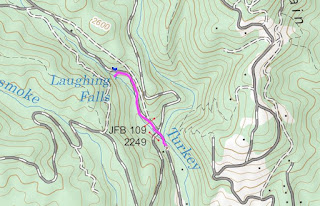
Map:
Hike Description:
Hike down the right gated road to a crossing of South Prong Turkey Creek. I was able to rock hop in low water but it might be tough in high water. Right after the crossing, turn left on a more overgrown road following the creek upstream. Go about a quarter mile and you can hear the waterfall and maybe see it through the trees. There's no real trail to the base and it's steep, but you can follow a path that others have used.


No comments:
Post a Comment