Showing posts with label Pisgah National Forest. Show all posts

Sunday, August 31, 2025

Cove Creek Hike

On Sunday, we savored a hearty breakfast before setting off for the Blue Ridge Parkway. Along NC-151, we paused to admire a charming roadside waterfall.


From the parkway, we wound down US-276 and turned onto Yellow Gap Road, reaching a small parking area about a mile in, where vibrant yellow wildflowers brightened the scene.


Just up the road, we joined the Barnett Branch Trail, turning left to ascend.


More wildflowers were blooming along the trail.


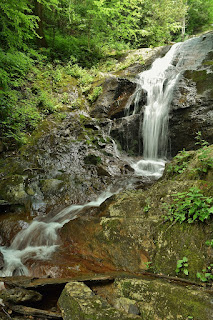
In less than half a mile, we reached the serene Barnett Branch Trail Falls, a hidden gem on a tributary of Barnett Branch.


Its beauty was striking for such an easy hike.


We lingered, clambering over rocks to snap photos before heading back.


Next, we drove to Davidson River Road and parked at Cove Creek Group Camp.


We hiked up the gated road, soon encountering a stunning small waterfall on Cove Creek just before the campground.


From there, we followed Caney Bottom Trail, then connected to Cove Creek Trail. In under a mile, a spur trail led us to Cove Creek Falls.


A light rain fell as we arrived, prompting me to shed my boots and wade for a better view.


Back on the main trail, we let Harper stretch her legs and hike a bit.


About a mile later, we crossed Cove Creek via a bridge and paused for a scenic lunch.


Some mushrooms were popping along here.


Continuing, we looped back via Caney Bottom Trail.


Roughly a mile in, we passed Caney Bottom Falls, but with no safe way down, we settled for a view from the trail.


There was a nice cascade on Caney Bottom Creek downstream of the falls.


The trail led us back to the campground, and we hiked the road to our car just as the rain intensified.


We capped the day with a cozy dinner at Stone Ridge Tavern before returning to the cabin to start packing.

Saturday, September 14, 2024

Return to Catawba Falls

Saturday, we left to take Harper for a week in the Smoky Mountains for her first birthday.  We left early and stopped on the way near Old Fort at the trailhead for Catawba Falls.  The area was closed for several years as the Forest Service was making improvements for safety and accessibility and had reopened at the beginning of the summer.  This would be our first visit since reopening.  Arriving at 8, it was raining lightly and there were only a few cars in the parking lot - a good thing we arrived early.  After getting Harper in her backpack, we set off on the Catawba Falls River Trail that mostly followed the old trail.


Soon, we came to a bridge at the ruins of an old hydroelectric building.


It used to be a rock hop across the river, but the bridge has been here for a few years.  The trail followed the river upstream with a moderate incline.  In about a mile, the trail passed Lower Catawba Falls.


Before the new trail, there was a scramble path down to the base, but that was no longer possible with the trail reroute.


We could see the upper portion of the waterfall from here, but the lower section with the small cave was not visible.  The only way down would be to backtrack to a point to get in the river and creek walk up, but weren't going to do that with a baby.  I did a quick loop on the short wildflower trail and then we continued on.


The stairs began shortly before we reached Catawba Falls and we could get out at the base.


The water level was a little low, but the waterfall was pretty in the light drizzle.


Although visible from the base, the stairs weren't as much of an eyesore as I expected.


Then we began the steep climb up the steps.  Several landings provided a view of the upper sections of the falls.


Carrying Harper, I took a few breaks to enjoy the view and catch my breath.  The old path to reach the upper falls was still visible beneath the steps.


The final part of the climb was up an observation tower that had nice views, especially from the top.


It was just a short ways further to Upper Catawba Falls.


The new viewing deck provided a nice view and we scrambled on the rocks for more pictures.


On the hike back, we took Catawba Ridge Trail to make a loop and avoid going down all those steps.  It was a bit more uphill and then started heading down.


Overall, I think they did a nice job in building the new trails and stairs.  I would prefer the wilderness experience but the area was so popular and so many incidents that something had to be done.  The parking lot was full when we got back, even with the rain, so glad we arrived early.


It was getting to be around lunch time, so we drove to Asheville and fajitas at Orales.  It was still a little early to check in, so we made a stop at the Folk Art Center along the Blue Ridge Parkway.  While Harper and Sandy browsed, I went for a hike on the Mountains-to-Sea Trail heading south/westbound.


There were some wildflowers blooming along the roadside and in open areas, but most were non-native.


I hiked just past the tunnel under I-40 and turned around.


On the hike back, a very large black bear popped out on the trail in front of me.  He turned and ran immediately but we sure was a big boy.  Sandy and Harper were about finished up and we took off.


We drove west to Bryson City and stopped at the visitor center to get a parking pass and then checked into our little cabin.

Saturday, August 17, 2024

Harper Creek Falls

Saturday, we took Harper to see Harper Creek Falls as we recently got the kid carrier backpack to take her on more hikes.  We left early and got to the Harper Creek Trailhead in Wilson Creek around 8 and the parking was already nearly full, mostly campers I imagine so early.  We got Harper in the backpack and headed off on Harper Creek Trail (#260).  Shortly after the split with MST, we took the unmarked trail to Harper Creek Falls.  At the top, I took off the backback and did a trial run down the ropes.  First I went down to the middle section.  It was a little slippery and I didn't feel confident going down with Harper.  But the path leading down to the base wasn't so bad.  The lowest section with the rope was a little slippery but I could secure my feet in a crack going down.  So I went back up to get Harper and we all made it down to the base to see the waterfall.


After getting her back up, I was getting tired so Sandy carried her back.  I took the opportunity to get some pictures of the mushrooms growing along the trail.


With the recent hurricane, the mushrooms were really popping.


I also saw a dark morph eastern tiger swallowtail.


When we got back to the car, there were a lot more cars here.


We continued through Wilson Creek, getting on FR-464 and driving up to the trailhead for North Harper Creek Falls.  Hiking down the trail, I spotted some green elfcup mushrooms that had stained the decaying wood.


We also saw a little red eft cross the trail.


Harper Creek Falls Trail led about a mile to North Harper Creek Trail (#266) where we turned left and headed steeply down, eventually reaching North Harper Creek.  We went downstream a bit and headed out into the creek at the base of Chestnut Cove Branch Falls.


It's actually on North Harper Creek at the confluence with Chestnut Cove Branch.


It's not too exciting, so we continued upstream to the much more scenic North Harper Creek Falls.


There's a nice area at the base where we ate a snack and let Harper splash around a bit.


Wading in the cool water helped me cool off before the steep climb back up carrying Harper.


From here, we left the forest and headed into Morganton for dinner at Las Salsas.  Then we checked into the Comfort Inn and relaxed for the evening.

Saturday, July 20, 2024

Big Ivy Hike

Saturday I left for the mountains for a week of waterfall chasing.  I left real early, getting to Asheville around sunrise and then heading into the Big Ivy/Coleman Boundary Area of Pisgah National Forest.  Right in the forest, I turned on FR-231 and drove to the end at Walker Creek Trailhead (#165).  Hiking up along Walker Branch, it crossed some nice cascades.


Then I got on Staire Creek Trail (183) and continued heading up along Staire Branch past some rocky cliffs.


There were some nice cascades along the trail as it headed though a rocky gorge.  After this point, it got pretty steep going up.  


There was an interesting rockhouse just off the trail with a stone wall and chairs.


The trail ended at FR-74 and I crossed and got on Bear Pen Trail (#176).  The first part of the trail was moderate and open, but as I got further up, the trail got steeper and more overgrown.  


As I got higher up, I started seeing more and more wildflowers.


The trail ended at Laurel Gap Trail, which was completely overgrown with the wildflowers.  


I don't think I've ever seen so many bee balm, coneflower and lilies in one place. 


It was really beautiful.  But it also sucked hiking through.  As it had rained overnight, the flowers were wet and soon I was completely soaked from practically bushwhacking down the trail.


I tried to focus on how beautiful all the flowers were and not how unpleasant the hike was.


When I made it to the road, I decided to not take this trail back.  Once was more than enough


There were more wildflowers along the road, but nothing like I had seen on Laurel Gap Trail.


And with the recent rains, mushrooms were popping up.


I hiked down to the end of FR-74 and picked up Douglas Falls Trail.


Even with the rain, the water level was a little low, but Douglas Falls was looking nice.  I had lunch here and tried to dry out my clothes a bit.


Then I walked behind and around the waterfall to view it from different angles.


There's a small cave in the cliffs behind the falls.


There was another couple here enjoying the falls as we talked about the area for a bit.


Hiking back, I took the road much of the way to avoid the overgrown trails.  Past Laurel Gap Trail, FR-74 Waterfall was right along the side of the road.


It's small, but rather pretty for a roadside.


I continued on past Staire Branch/Bear Den and then to Walker Creek/Perkins Trail.  I headed up along Perkins Trail (#175) for about a half-mile or so to where it crosses Walker Creek.


I thought Upper Walker Falls was here, but I couldn't find it.  I'll have to research this one more, but didn't feel like bushwhacking.  Then I headed back down to the road and continued to Walker Falls.


This is a pretty big roadside waterfall.


I scrambled down to the base, but I think the view from the road itself is best as you can see the upper sections.


Then I headed back to Walker Creek Trail and took that back down to the trailhead.


From here, I headed back to the highway and stopped for an early dinner at Mars Theatre Brewing Company.  Then I continued to Johnson City and checked into the Staybridge Suites.