Harper Creek Falls is a 50-foot waterfall in three sections on its namesake, a tributary of Wilson Creek, in Caldwell County, North Carolina. The waterfall is located in the Wilson Creek area of Pisgah National Forest.
Hike Length: 3.0 miles
Estimated Time: 2 to 3 hours
Difficulty: Moderate
Location: Wilson Creek (Grandfather Ranger District of Pisgah National Forest)
Trail Users: Hiking only
Dogs: Yes
Features: Waterfalls (1)
Crowds: High
Warnings: The rocks around waterfalls are slippery. The path down to the base and the middle section is very steep and may require the use of ropes.
Trailhead GPS: 35.97754,-81.76643
Waterfall GPS: 35.98304,-81.77973
Directions:
From Morganton, head north on NC-181 for about 12 miles and turn right into the Brown Mountain Beach Road. Drive 5.1 miles and turn right to stay on Brown Mountain Beach Road, which changes to gravel. Go 7.2 miles to a parking area on the left. Only park in designated spaces or your vehicle may be towed.
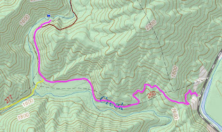
Map:
Hike Description:
From the parking area, pick up the Harper Creek Trail (#260) that climbs up the ridge via switchbacks. In about 0.2 miles, the trail reaches the top of the ridge and a junction with Yellow Buck Trail (#265). Go straight to stay on Harper Creek Trail, which is more gradual. At about 1.1 miles, Raider Camp Trail (#277)/Mountains-to-Sea Trail comes in from the left. Stay straight on Harper Creek Trail, which is also MST now. At 1.4 miles, Harper Creek Trail/MST bears right and heads up. Go straight on the unmarked trail a short ways to the top of the waterfall.
The first scramble path on the left heads down to the base. It is quite steep and you may need a rope for the lowest part.
The second scramble path leads down to the middle of the falls. A rope is tied here to make the steep descent.
Here's a video of the falls.
25-May-2014: More Wilson Creek Waterfalls
26-May-2012: Harper Creek Loop
External Links:
US Forest Service website: https://www.fs.usda.gov/recarea/nfsnc/recreation/recarea/?recid=49038


No comments:
Post a Comment