Showing posts with label Wilson Creek. Show all posts

Saturday, August 17, 2024

Harper Creek Falls

Saturday, we took Harper to see Harper Creek Falls as we recently got the kid carrier backpack to take her on more hikes.  We left early and got to the Harper Creek Trailhead in Wilson Creek around 8 and the parking was already nearly full, mostly campers I imagine so early.  We got Harper in the backpack and headed off on Harper Creek Trail (#260).  Shortly after the split with MST, we took the unmarked trail to Harper Creek Falls.  At the top, I took off the backback and did a trial run down the ropes.  First I went down to the middle section.  It was a little slippery and I didn't feel confident going down with Harper.  But the path leading down to the base wasn't so bad.  The lowest section with the rope was a little slippery but I could secure my feet in a crack going down.  So I went back up to get Harper and we all made it down to the base to see the waterfall.


After getting her back up, I was getting tired so Sandy carried her back.  I took the opportunity to get some pictures of the mushrooms growing along the trail.


With the recent hurricane, the mushrooms were really popping.


I also saw a dark morph eastern tiger swallowtail.


When we got back to the car, there were a lot more cars here.


We continued through Wilson Creek, getting on FR-464 and driving up to the trailhead for North Harper Creek Falls.  Hiking down the trail, I spotted some green elfcup mushrooms that had stained the decaying wood.


We also saw a little red eft cross the trail.


Harper Creek Falls Trail led about a mile to North Harper Creek Trail (#266) where we turned left and headed steeply down, eventually reaching North Harper Creek.  We went downstream a bit and headed out into the creek at the base of Chestnut Cove Branch Falls.


It's actually on North Harper Creek at the confluence with Chestnut Cove Branch.


It's not too exciting, so we continued upstream to the much more scenic North Harper Creek Falls.


There's a nice area at the base where we ate a snack and let Harper splash around a bit.


Wading in the cool water helped me cool off before the steep climb back up carrying Harper.


From here, we left the forest and headed into Morganton for dinner at Las Salsas.  Then we checked into the Comfort Inn and relaxed for the evening.

Saturday, February 18, 2023

Shortoff Mountain

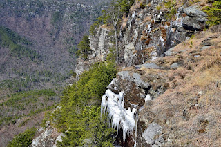
Saturday, we took Alex out to the mountains for a long weekend of camping.  We left early and arrived at the Wolf Pit Trailhead for Linville Gorge before 9, but the parking area was already nearly full.  I was surprised it was so crowded in February, but it was nice weather, albeit a little cold.  Linville Gorge is Alex's favorite place to hike, especially on a cold day.  We set off on the trail and headed up though not too steeply.  There was a little bit of ice on the trail.  After meeting up with Mountains-to-Sea Trail, we started getting some nice views and there were a lot of icicles up here.


With full sun and rising temperatures, the icicles were melting quickly.  Continuing on, we started to get views of the gorge as the trail turned north.


There were great views of Table Rock in the distance.


We went to the last good viewpoint and had a break here.  I think this is one of the best views around and shows the depth of the gorge along with the cool rock formations below the Chimneys.


We had a snack up here and then started making our way back.  There were some more nice icicles to see but I don't think they'll be there much longer.


On the way down, I ran into two backpackers who weren't sure where they were going to camp.  I suggested the spot where we had taken a break as one of the best campsites around and it was still open as of when we left.


There were some nice views of Lake James on the hike down.  I also talked to a guy from Marion about the history of Duke Tobacco and cigarettes.


It was still too early to check in to camp, so we headed up NC-181 to the trailhead for Upper Creek Falls.  We started on the upper section of the trail and descended to the top of the waterfall.  With the water way up, crossing the creek was difficult.  Two other people with dogs managed to get across, but Alex didn't want to, so Sandy took him back to the car.  I waded across to see the waterfall, but the light was poor, too bad since the water level was so high.


I then headed down to the lower crossing, which was even more difficult.  The two guys with dogs gave up and headed back the other way.  I was able to get across and took the switchbacks back up the car.


From here, we went to Carbon City Grill for dinner and then to Lake James to set up camp for the night.  It got rather chilly once the sunset, but we made a nice fire.  Even Alex slept with a blanket to stay warm.

Saturday, June 19, 2021

Lost Cove Loop

Saturday morning, we woke up and headed back to FR-464 for another hike in Wilson Creek.  Alex would be completing hike 9 for #MST40hikes - Waterfalls!


This time, we parked at the trailhead for Hunt Fish Falls Trail.  This trail headed steeply down to Lost Cove Creek in just under a mile.  Near the end, there were some switchbacks and some cliffs here.


A path led along the cliffs out to rock with a view of Hunt Fish Sidekick Falls from the middle.


From here, we went back to the trail and turned right on Lost Cove Creek Trail (#262).  The trail crossed below the base of Hunt Fish Sidekick Falls.


Here we could walk out on the rocks for a view of Hunt Fish Falls.


We had arrived early enough that it wasn't crowded yet, rare for this waterfall in the summer.


After some pictures, we continued on Lost Cove Trail following the creek downstream.  We had to wade Lost Cove Creek and after the confluence with Gragg Prong, we had to wade that creek as well.


Soon we came to Gragg Prong Falls.


A climbed out on a rock part of the way down for a nice view of the falls.  But it would have been tough to go further down so I didn't make it to the base this time.


Continuing on the trail, we stopped to see a nice cascade on the creek.


Soon, we arrived at Middle Gragg Prong Falls.


Surprisingly, no one else was at this one yet.  So we walked around on the rocks a bit to get some pictures of the waterfall.


Soon enough, a few more people showed up so we took off.  In another half-mile, we took a path that led down to the creek at Upper Gragg Prong Falls.


There was one other group here, but they were down by the creek, so we climbed up the big rock to eat lunch.  I waded in the creek for some pictures and then we headed on.


At the trailhead on FR-981, I wanted to finish the Lost Cove Loop.  There was a trailhead sign that said Timber Ridge Trail (#262), but Timber Ridge is #261 and Lost Cove is #262, so I followed that trail as it went in the general right direction.  But it was not Lost Cove Trail.  In a little over a mile, I came to the actual Timber Ridge Trail (#261) and went right to head up to the summit of Bee Mountain.


There was absolutely no view here and I was unable to figure out where Lost Cove Trail met up.  But heading down, Lost Cove Trail was pretty easy to follow.  The first part was incredibly steep, but at least I was going down.  There was one spot with a decent view from the trail.


The trail moderated and continued descending via switchbacks to Lost Cove Creek.  I had to cross the creek and the first mile of trail was pretty easy to follow.  Then it got rather hard to follow as I had to cross the creek a couple times.  But I kept following the creek downstream and eventually made it back to Hunt Fish Falls.


After finishing our hike, we headed into Newland for dinner at Carolina Barbecue.  Then we headed back to camp for one more campfire.

Friday, June 18, 2021

Lost Cove Cliffs

Friday morning, we took Alex for a long weekend of camping in the mountains.  We drove out to Morganton and took NC-181 into Pisgah National Forest.  Driving down FR-982, we turned on FR-197 and found a nice spot along Upper Creek to set up camp.  Then we drove to FR-464 into the Wilson Creek area and parked at the trailhead for North Harper Creek Shortcut (#266A).  We hiked down the trail, which is also part of the Mountains-to-Sea Trail, down to North Harper Creek and turned left on Harper Creek Trail (#266).  Shortly, we had to wade the creek.


After crossing, the trail passed the top of Bard Falls in another half-mile.  A little further was a scramble path down to the base of the falls.


Unfortunately, it was very sunny and not a cloud in the sky.  I played around on the rocks a little to get some pictures.


The pothole next to the falls was really cool.


Since there didn't look like any chance for a cloud, we headed back.  Driving back on FR-464, we stopped again in a half-mile at the trailhead for Darkside Cliffs.  Darkside Cliffs Trail (#272) was an easy half-mile trail out to the cliffs.


The views of Grandfather Mountain and Grandmother Mountain (with the tower) were great from here.  Down below we could see Lost Cove where we would be hiking tomorrow.


We took a short break here and headed back.


We drove a mile or so back up FR-464 and stopped one more time at the North Harper Creek Falls and Little Lost Cove Cliffs Trailhead.  We first hiked North Harper Creek Falls Trail (#239) down towards North Harper Creek.  The trail ended at North Harper Creek Trail just above North Harper Creek Falls.  


I went out on the rocks for a view of the water flowing down the rock face.  


For whatever reason, I thought we were downstream of the falls so we went right on North Harper Creek Trail (#266).  After a while, I realized we were going the wrong way.  Alex was getting tired so we didn't backtrack and just continued on the trail up to FR-58.  There were some fire pink flowering along the creek.


We hiked FR-58 to FR-464 and continued to the other trailhead for Little Lost Cove Cliffs Trail (#271A).  About half-way along the trail, a short spur led to the cliffs.


We climbed up on the rocks and took a short break, enjoying the views.


Like Darkside Cliffs, there were great views of Grandfather Mountain in the distance.


After a break, we finished up Little Lost Cove Cliffs Trail back at the start of the loop.


From here, we drove back to paved roads and headed into Pineola for pizza at Italian Restaurant.  Then we headed back to camp and built a fire before going to bed.