Thursday, December 31, 2020

Rabun Bald

Thursday, we headed back into Georgia and parked again at the Sky Valley Overlook.  It was another beautiful view with clouds over the valley.


Today, we were going for a hike here.  Mud Creek Trail picked up just past the overlook and followed the creek upstream.  There were some scenic cascades along the trail.


It was about a mile to the end at Mud Creek Falls.


It's possible to park right by the waterfall, but it was a nice hike up along the creek.


The waterfall was very scenic in the early morning light.


There was a hemlock tree growing around a rock here that was very interesting.


We enjoyed the view and then made the hike back.


The clouds had cleared from the overlook by the time we made it back.


Next, we continued into Sky Valley and parked at the trailhead for Rabun Bald at Beegum Gap.  The Bartram Trail led south from here towards the summit of Georgia's second highest peak.  In about a mile, FR-413 rejoined with Bartram Trail.  It got a little steep at this point as it switchbacked up through some rhododendron tunnels.


It then leveled off before reaching the lookout tower at the top.  We climbed up here to enjoy the views.


As the highest point around, there were great 360° views.


We had lunch up here, but soon more people started showing up, so we started hiking back.  At FR-413, we turned to make a loop on the hike back.


We started making our way back to North Carolina, pulling over on NC-106 at the Blue Valley Overlook.


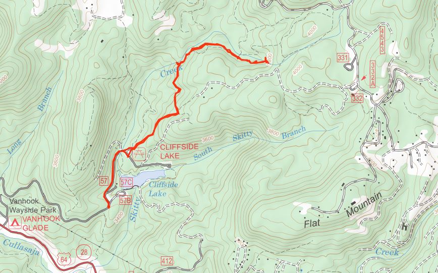
Then we drove through Highlands and stopped at Cliffside Lake Recreation Area.  It's closed for the winter so we parked before the gate and hiked up to the Clifftop Vista Trailhead and got on the Ranger Falls Trail.  It ascended gradually then we took a split to the left to descend down towards Skitty Creek.


In just over a mile, the trail crossed the creek just below Ranger Falls.


On our last visit, the waterfall was barely a trickle, so nice to visit in much better water flow.


In high water, it's a nice waterfall and the rock that it flows over is very colorful.


We got some pictures and then made the hike back.


Continuing back towards Franklin on US-64, we made one more stop.  We took a turn on Ellijay Road and stopped at the roadside Katie's Falls.


A plaque by the waterfall said it was named by a local for his daughter in the early 20th century.


Then we headed to Franklin and had dinner at Lazy Hiker with Alex.  Then we headed back to Colin's place for New Years Eve.

Wednesday, December 30, 2020

Highlands Waterfalls

Wednesday, we headed towards Highlands on US-64 and took Buck Creek Road about 5 miles to a switchback in the road and parked.  Gated forest road 4571 led down to a split and we went right.  Where the trail turned right, we got off the main road and followed a more overgrown road high above Buck Creek.  At some flagging tape, we got off this road and started bushwhacking down towards the waterfall.  It was very steep but relatively open so not too bad.  We soon came to the top of Buck Creek Falls.


A path on river right led steeply down along the waterfall.


We made it to the base, but the water was too high to cross and there wasn't much of a view from this side.  A little further up, there was a spot to scramble out for a nice view.


It was a pretty scenic waterfall, very high and we enjoyed the view from here for a bit.


Then we made the steep scramble back up to the road and short hike back to the car.


Next, we continued into Highlands and went south on NC-28.  We turned on Clear Creek Road and then FR-367 and made a stop at the roadside Brooks Creek Falls.


I thought it was really nice for a roadside waterfall.  I followed a short path to a closer view.


Then we drove a short ways further to Brooks Creek Tributary Waterfall.


It's smaller and pretty overgrown but worth a quick stop.


Then we continued driving into the forest.


At FR-79, we turned right and drove to a right-hand turn and parked.  A short hike down an overgrown road led to the top of Chasm Falls.


I had visited before but didn't make it to the base so today I was determined even in the high water.  A scramble path led down to the base and I was able to get to the other side without getting my feet wet.  But there was a big log down and the waterfall was partially blocked by the chasm.


So I waded and climbed up and over the log to get a clear shot of the waterfall.


It's a real beauty and worth getting wet for.  Our next stop was just up the road at the gated forest road.  We followed this road to Picklesimer Rock House Falls.


The waterfall is named for the huge shelter cave behind it.


Unfortunately, a large tree had fallen over it and it didn't look like it would be going anywhere soon.


We took a break and had lunch under the rock house.


We made one more stop before leaving the Blue Valley area.  We followed FR-79C to the end and planned to hike to Glen Falls from below.  But the river was so high, we were unable to get across.  Heading back, we stopped along FR-79C at Chinquapin Falls.  We bushwhacked up to the base, but it was really overgrown.


Even in high water, it didn't seem worth the effort to go further up.


From here, we drove back to Highlands and made our way through the Cullasaja River Gorge heading back towards Franklin.  Just after Lake Sequoyah, we pulled off next to the dam.


A short but very steep and sketchy scramble path led down to a view of Kalakaleskies Falls just downstream of the dam.


There were some more cascades downstream, but it was bad enough getting to this point.


I scrambled back up and we continued on.  In about another half-mile, we stopped at Bridal Veil Falls.


The road behind the falls was closed to motor vehicles.  Not sure if it's permanent or just for the winter, but we could still walk behind it.


Next, we continued up the road to the pull-off at Scadin Falls.  A steep path led down from the road to a split.  Going left led to the upper portion of the falls.


This part was just above the big drop.


To see the main drop, we headed back to the split and went left to go out on a big rock in the river.


There was a great view of the waterfall from here.  I was really impressed with this one.


After some pictures, we headed back.  Another mile or so up the road, we stopped again for Quarry Falls.


I scrambled around on the rocks to get some pictures.


Then we made one final stop for Cullasaja Falls.


I scrambled down from the road a ways but didn't make it to a clear view.


I would have had to rappel to go any further down and with the waning daylight and wet rocks, I decided not to.


That was our last stop of the day and we headed back to Franklin.