Sunday, October 9, 2022

Mount Pisgah Hike

Sunday morning, we had a nice breakfast at the hotel and then checked out.  We drove back up to the Blue Ridge Parkway and stopped at the trailhead for Mount Pisgah.  The trail was only 1.5 miles to the top and moderate with a few steep sections, mainly near the end.


There were some showy gentians flowering along the trail.


Soon we made it to the top where a small wooden overlook to take a break.


It was cloudy right when we arrived, but they quickly burned off.  We spent about 20 minutes up here enjoying the view.


Back down at the parking area, there was a great view of the mountain once the clouds had cleared.


We got some pictures and then took off.


Driving back towards Asheville, we made a couple stops along the way.  First we stopped at View Stony Bald with a distant view of Mount Pisgah.


Then we stopped at Bad Fork Valley Overlook.


The fall color along the parkway was really beautiful here.


Then we drove the rest of the way to Asheville and started making our way home.  In Old Fort, we stopped at Hillman for beer and lunch.

Saturday, October 8, 2022

Graveyard Ridge MST Hike

Saturday, we took Alex to the mountains for some early fall foliage hiking.  We left very early and got on the Blue Ridge Parkway near Asheville right around sunrise.  We made one quick stop at View Chestnut Cove for a nice sunrise view.


Then we continued to Black Balsam Road and the trailhead for Art Loeb Trail and the Mountains-to-Sea Trail.  Alex would be completing hike 4 for #mst40hike.


We set off one the MST and enjoyed the lovely fall color at high elevation.


The color was really popping up here.


In about 1.5 miles, we passed the first junction with Graveyard Ridge Trail with views looking north into Shining Rock.


After the second junction with Graveyard Ridge Trail and the MST Connector, we got off the trail near a campsite and went down to Yellowstone Prong.


Since we had the dog, we took turns heading down to Yellowstone Falls.  After crossing the creek, I followed the steep trail down, eventually coming out near the middle of the waterfall.


Going any further would be difficult.  It looked like a landslide had taken out most of the path down to the base.  I managed to get down and a tree had fallen right over the falls, so it was definitely not worth the climb down.  Sandy did not try to get down here.


We headed back up and continued on the trail.  I warned a couple other folks about the base of Yellowstone Falls.  Although it was fall, there were still a lot of asters blooming.


In another mile or so, we came to what's left of Skinny Dip Falls after the destruction from Tropical Storm Fred.


Massive boulders were moved around in the creek and the waterfall looked very differently than before.  It was still a popular spot though.


It was about 1.5 more miles to the end of the hike at View Cherry Cove.


There was a nice view of Looking Glass Rock from here.


Sandy and Alex waited while I headed back to the car.  I took Graveyard Ridge Trail to make a partial loop on the way back.


I finished up the hike and then drove back to pick up Sandy and Alex.


From here, we drove to Sapphire and checked into Brook Trout Inn.  For dinner, we headed to Micas and had a pizza on the deck with Alex.

Saturday, October 1, 2022

Snoqualmie Falls

Saturday morning, we had a delicious breakfast at the hotel then packed up and checked out.  We headed to Olallie State Park at the Twin Falls Trailhead.  Arriving early, it wasn't too crowded.  Setting out on the trail, we followed South Fork Snoqualmie River upstream.


There were a few points to go out to the river.


The trail then climbed a bit and we reached the first overlook for the waterfall, but it as hard to see.


In about a mile, a spur trail led down to a view of the lowest drop of Twin Falls.


At 135 feet, it was really impressive.  With the water low, the beautiful rock was visible beneath the streams.


Heading back up to the trail, a footbridge led over the river with a view of the middle drop.


The lower drop was just downstream and the upper drop was partially visible.


A little further up the trail, we had a view of the upper drop, but it was blocked by foliage.  A scramble path led down to the base with a rope tied off near the end where it got really steep.  But we had a good view of the third section.


Twin Falls doesn't really make sense as a name for this one.  But it was a great waterfall to visit.


From here, we wanted to make one more stop before the airport at Snoqualmie Falls.  We parked at the free lot and took the footbridge across for a view from the upper overlook.


The lighting was poor with the midday sun and not a cloud in the sky.  The water level was low and most is diverted for hydroelectric generation, but it was still quite impressive.  At 268 feet high, it's one of the high in Washington.  We followed the trail down to the lower parking area at river level.


The trail ended at the lower viewpoint of the falls.


We got a few pictures from here, then hiked back.


Back at the car, we got our stuff reorganized and headed back to the car rental return.

Friday, September 30, 2022

Quinault Rainforest

Friday morning, we hiked near the lodge around the Quinault Area.  Behind the lodge, we got on Resort Trail (#854.4) that led to Wright's Canyon Trail (#854.3).  Soon, we crossed a bridge at
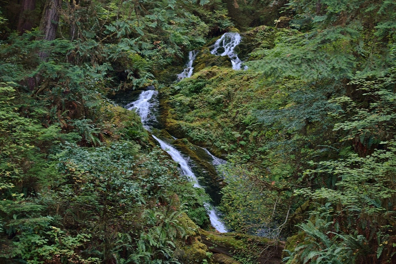
 Gatton Creek Falls.


From the bridge, some upper cascades were visible.  I climbed down to see more cascades.


And I could peer over the top of the main drop of the waterfall, but there didn't seem to be any way to continue down.


Shortly after the bridge, we turned right on Upper Gatton Creek Loop (#854.2) and passed through a beautiful rainforest.  There were some gigantic Douglas fir trees.


There were some red-belted conk mushrooms growing on a dead log.


This trail made a 1.5-mile connector between Wright's Creek Trail and Quinault Loop.


It was really beautiful.  We saw more stairstep moss along the trail.


There were a few banana slugs; we had to watch out to not step on them.


We also saw some bright orange chicken of the woods.


At Quinault Loop (#854), we turned left.


It was a short ways to a bridge over Cascade Creek with some little cascades.


Cascade Falls was just downstream.


We scrambled down to the creek from the trail for a view of this scenic waterfall.


Then we turned back on Quinault Loop and started heading down towards the lodge.


After crossing South Shore Road, we could see Falls Creek Falls.


Crossing the bridge over to the campground, we could get down to the creek for a frontal view.


It falls in two streams but the water level was low.  From here, we hiked back to the hotel and checked out then parked at the Quinault Rainforest Trailhead.  Taking the interpretive loop, we passed another immense Douglas fir.


At Willaby Creek, we turned left on Quinault Loop to go down to Willaby Creek Falls.


It's only about 15 feet, but really scenic tucked away in the little gorge.


There was also a view from the trail.


We returned to the interpretive trail and hiked the short loop, following along Willaby Creek initially.


The trail then looped back around away from the creek.


The redwood sorrel had very large clover leaves.


The massive trees and thick vegetation along the trail was really beautiful.


We finished up the loop and then continued on down South Shore Road.


Our next stop was a few miles up the road just before the bridge over Merriman Creek.  Merriman Falls could be seen from the road.


It was a really nice waterfall.  With low water, it was easy to scramble and climb around on the rocks at the falls.


The mossy rocks were really beautiful.


After some pictures, we continued on.


Continuing up South Shore Road, we parked at the Fletcher Canyon Trailhead.  The scenic trail led past some big boulders and into the rainforest.


The forest was very lush around here and in a quarter-mile or so, we crossed into Colonel Bob Wilderness.


There was some chicken of the woods growing here.


The trail continued up way above the canyon.


Eventually, it drops down into the canyon, but we were running low on time, so turned around after about a mile.


But we had one more stop before leaving the area, less than a mile up the road just before the bridge over Bunch Creek.  We could see Bunch Falls from the road.


I scrambled up on the rocks for a close view, but there was a lot of vegetation in the way.


We climbed around for a while then finished up.


Now it was time to leave the beautiful Olympic Peninsula.  We made the long drive to North Bend and checked into Roaring River B&B just before sunset and enjoyed the hot tub before going to bed.