Sunday, July 21, 2024

Rogers Ridge Hike

Sunday, I headed to the northeast corner of Tennesssee to the Rogers Ridge Scenic Area in Cherokee National Forest.  I first drove to the end of the road and parked at the trailhead for Gentry Creek Falls.  We had tried this waterfall before in very high water, but Alex was not able to cross so we couldn't get it.  But today the water level was lower.


In fact, I didn't even get my feet wet as I could rock hop all the crossings.  There were some scenic cascades along the trail.


There were some beebalm flowering along the creek, but nothing like yesterday.


In a little over 2 miles, I made it to the beautiful Gentry Creek Falls.


The waterfall consists of two 30-foot drops though the upper drop is not as easy to see.


Although the creek was low, the waterfall still looked really nice.


I thought about climbing to the upper section, but with low water, the sun poking out and being alone, I decided not to.  Back at the car, I drove back on the forest road, thankful there was no oncoming traffic as it is very narrow with almost no pull-offs, and parked at the Rogers Ridge Trailhead.  It's a larger parking area, suitable for horse trailers, as Rogers Ridge Trail is mainly a horse trail.  After crossing Gentry Creek, which I could rock hop, it headed steeply up the ridge.  And being a horse trail, there weren't any switchbacks, just straight up and up and up.


It leveled off in a few places, but it was just a tease as there was always another steep section.  After about three miles, an old road came in and it got kind of confusing, but all routes seemed to head straight up.  I found a few blazes to stay on the right trail.  There was one open area and then another very steep section until it finally opened up to the balds after more than five miles.


The views when I finally reached here was fabulous and made the steep hike up worth it.


But after descending a bit, there was another steep uphill to what I believe is the end of the trail as well as the high point.


A path to the east looked like it headed into North Carolina, less than half a mile away.  I had lunch up here, enjoying the view then headed back down.  At least it was mostly downhill.


Near the end, I saw a big rat snake across the trail.  He didn't seem to want to move, so I went around.


Back at the car, I headed back to Johnson City and stopped in downtown for dinner.  I got tacos from White Duck and beer from Yee-Haw.  The orange creamsicle IPA was really good, but I drank the last of it.  After dinner, I went back to the hotel for the evening.

Saturday, July 20, 2024

Big Ivy Hike

Saturday I left for the mountains for a week of waterfall chasing.  I left real early, getting to Asheville around sunrise and then heading into the Big Ivy/Coleman Boundary Area of Pisgah National Forest.  Right in the forest, I turned on FR-231 and drove to the end at Walker Creek Trailhead (#165).  Hiking up along Walker Branch, it crossed some nice cascades.


Then I got on Staire Creek Trail (183) and continued heading up along Staire Branch past some rocky cliffs.


There were some nice cascades along the trail as it headed though a rocky gorge.  After this point, it got pretty steep going up.  


There was an interesting rockhouse just off the trail with a stone wall and chairs.


The trail ended at FR-74 and I crossed and got on Bear Pen Trail (#176).  The first part of the trail was moderate and open, but as I got further up, the trail got steeper and more overgrown.  


As I got higher up, I started seeing more and more wildflowers.


The trail ended at Laurel Gap Trail, which was completely overgrown with the wildflowers.  


I don't think I've ever seen so many bee balm, coneflower and lilies in one place. 


It was really beautiful.  But it also sucked hiking through.  As it had rained overnight, the flowers were wet and soon I was completely soaked from practically bushwhacking down the trail.


I tried to focus on how beautiful all the flowers were and not how unpleasant the hike was.


When I made it to the road, I decided to not take this trail back.  Once was more than enough


There were more wildflowers along the road, but nothing like I had seen on Laurel Gap Trail.


And with the recent rains, mushrooms were popping up.


I hiked down to the end of FR-74 and picked up Douglas Falls Trail.


Even with the rain, the water level was a little low, but Douglas Falls was looking nice.  I had lunch here and tried to dry out my clothes a bit.


Then I walked behind and around the waterfall to view it from different angles.


There's a small cave in the cliffs behind the falls.


There was another couple here enjoying the falls as we talked about the area for a bit.


Hiking back, I took the road much of the way to avoid the overgrown trails.  Past Laurel Gap Trail, FR-74 Waterfall was right along the side of the road.


It's small, but rather pretty for a roadside.


I continued on past Staire Branch/Bear Den and then to Walker Creek/Perkins Trail.  I headed up along Perkins Trail (#175) for about a half-mile or so to where it crosses Walker Creek.


I thought Upper Walker Falls was here, but I couldn't find it.  I'll have to research this one more, but didn't feel like bushwhacking.  Then I headed back down to the road and continued to Walker Falls.


This is a pretty big roadside waterfall.


I scrambled down to the base, but I think the view from the road itself is best as you can see the upper sections.


Then I headed back to Walker Creek Trail and took that back down to the trailhead.


From here, I headed back to the highway and stopped for an early dinner at Mars Theatre Brewing Company.  Then I continued to Johnson City and checked into the Staybridge Suites.

Saturday, July 6, 2024

Dix Park Sunflowers 2024

Saturday, we took Harper to the sunflowers at Dorothea Dix Park for her first time.  It's been so hot this summer, we got there right around sunrise to beat the heat and crowds.


And it was still pretty warm and muggy at 6 in the morning, but the sunflowers were beautiful in the early morning light.


The sunflowers seemed shorter this year than when visiting the past, maybe because of the very dry June we had.


We weren't the only ones enjoying the sunflowers first thing in the morning.  Bees, butterflies and other pollinators were busy at work in the field.


We got some pictures of Harper with the flowers and made a loop around the field, but it was warming up quickly.


Sandy and Harper took off and I continued hiking for a while on the Capital Area Greenway.  I took Rocky Branch Trail to Walnut Creek Trail and made a partial loop with Centennial Campus Connector.  By 10, it was really hot and I was glad to get back to air conditioning.


Saturday, June 29, 2024

Crabtree Creek West

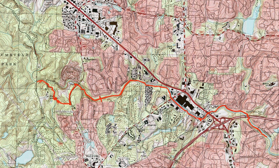
The final segment of Crabtree Creek Trail was recently finished, completing the 17-mile trail in the Capital Area Greenway.  Saturday was going to be really hot, so I got an early start at the trailhead for Crabtree Creek West along Ebenezer Church Road before 7.  The trail starts where Crabtree Creek leaves Umstead State Park, where the multi-use trail bridge has been removed.


Following the trail, it crosses Richland Creek on a footbridge just above the confluence.


Past here, it heads away from the creek and climbs up a ridge via an elaborate switchback structure.


In about a mile, the greenway comes out on Duraleigh Road and follows the sidewalk back to the creek.  Where the road crosses, the trail goes down and under the bridge.


Shortly past here was a large suspension bridge over the river.


I believe this was the last piece of the trail to be constructed.


In about 2 miles, the trail reaches Lindsey Drive, the former western terminus of the trail.  They made another bridge over the river that connects to Picardy Drive.


Past here, it was existing trail.  I went a few more miles, past the mall and beltline and then turned around as it was really warming up.