Showing posts with label Falls Lake. Show all posts

Saturday, January 23, 2021

Falls Lake Trail to Little Lick Creek

Saturday, we took Alex to get his next hike for the MST 40 Hike Challenge, Hike 22 - Falls Lake Trail from Rolling View to Little Lick Creek.


We parked at the hiker lot at Rolling View Recreation Area in Falls Lake State Recreation Area and took the spur trail to Falls Lake Trail and turned left to hike Section 14.  Shortly after leaving state park land, we crossed an intermittent stream and there were nice winter views of the lake.


We passed a nice little beach and went down to the shore line.


Continuing on, we came to a private gravel road at about 3 miles and crossed a tributary and then back into the woods.


Right past here, we spotted the remains of some old cars off the trail.


At the end, we crossed the bridge and the boardwalk and took a break at the bench.  I ran up to Jimmy Rogers Road and then we headed back.  We made a detour on an old road out to the lake.


Then we made the hike back.  I took a detour through Rolling View before heading back.


Saturday, April 25, 2020

Osprey at Blue Jay Point

Saturday, we took Alex for a hike along Falls Lake Trail at Blue Jay Point County Park.  We parked along Six Forks Road at Upper Barton Creek and hiked into the park.  It was a late spring day, but there were still some good wildflowers to see along the trail.


There was one lone atamasco lily and a few jack-in-the-pulpits.


We came to a parking lot where a sign indicated distances along the Mountains-to-Sea Trail.


Past here, some mountain laurel were blooming.


When we got to the old road going out to Blue Jay Point, we headed down there.  A double-crested cormorant could be seen in the distance.


And there was a great blue heron near the small island.


At the point, a nesting pair of ospreys had build a nest in a tree.  We spotted both of them flying around, one brought back some branches to repair the nest and the other had half a fish in his talons.


We watched the ospreys for a while and then continued on.  We went a ways on Section 5 of Falls Lake Trail and then turned back.


Sunday, January 7, 2018

Frozen Falls Lake

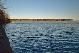
Sunday, I was continuing my hikes along the Falls Lake Trail.  This week was Section 14 from Rolling View to Little Lick Creek.  It was very cold when we started just after 9 from the trailhead parking just before the entrance to Rolling View Recreation Area, part of Falls Lake State Recreation Area, on Baptist Road.  We followed the blue-blazed spur trail to the MST and then headed westbound.  With the leaves down, we soon had views of the lake from the trail and it was frozen.  After a mile or so, the trail passed next to a small beach on the lake so we headed down to check it out.  And sure enough, the lake was frozen, pretty much solid.


I wouldn't have walked on it, but it looked thoroughly frozen.  George tossed a rock out on the lake and it made a weird echoing sound.  Further along the trail, we passed by a pasture where some horses were grazing.


They were wearing jackets too!  This section of the trail ends at Little Lick Creek where a bridge crosses the creek.  Past the bridge, an elevated boardwalk crosses a normally wet area.


The water level at Falls Lake is so low, this is all dry ground.  We took a quick break and turned around here.  Across the bridge, I went out on the normally submerged area to get a couple pictures of the bridge.


Heading back a little ways, I took an old road down to lake level to get a couple more pictures of the frozen Falls Lake.


I've been hiking here for years and this is the first time I've ever seen it freeze like this.


Saturday, December 23, 2017

Redwood Road Detour

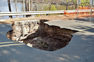
Saturday, we took Alex for a hike at Falls Lake Trail.  Last year on my Falls Lake hike, a sinkhole had formed in Redwood Road.


It was closed to traffic, but we could hike it to connect sections 17 and 18.  Since then, the road has been completely removed and there is no way to cross, on foot or otherwise.  Initially, there was a 7 mile road walk to detour around for the Mountains-to-Sea Trail.  Now, there is a 2-mile trail hike for a detour, so we went out to check it out.  We parked on Hereford Road at the east trailhead for section 17.  This section is a little over a mile and we came out at Redwood Road.  To the right, the road was barricaded, but a blue-blazed trail picked up across the street.  The trail was very well blazed and easy to follow heading upstream on Panther Creek.  About a mile up at the creek crossing, there was no reasonable way across.


So we bushwhacked upstream to just past an island in the creek and found an easy to cross and stay dry.  Continuing through the woods a short ways, we came to an old abandoned railway and turned right.  This old railway went all the way to Redwood Road on the other side of the gap.


Part of the way down, was the remains of an old bridge - much safer to just go around this one.


As we got to Redwood Road, I went out to the lake, since the water was so low to get a picture of Redwood Road.


We continued on sections 18 and 19 and went as far as the tunnel under I-85 before turning around.


Sunday, February 26, 2017

Trout Lilies and Wildflowers

Although it hit 80 yesterday, it was feeling a bit more like February today.  With a high around 50, it was quite a bit cooler, but still a great day for a hike at Falls Lake Trail.  We hiked the last section, 23 from Red Mill Road to Old Oxford Highway.  A number of small wildflowers were blooming along the trail.


After passing the campsite, I started to see some trout lilies.  These little flowers are usually the first to bloom in spring.


Further on, we crossed a bluff above the Eno River and came to an old abandoned railroad tracks.  We followed the tracks a short ways to a bridge over the river.


Then we finished at Old Oxford Highway and crossed to Penny's Bend and took a break at the river.  


After a short break we headed back.


Sunday, February 19, 2017

Early Spring at Falls Lake

Today, we hiked the next section of Falls Lake Trail - section 22 that starts and ends on Red Mill Road.  It was a beautiful day, feeling a lot more like spring than winter. We parked just across the bridge over Ellerbe Creek and got on the trail.  The trail follows Ellerbe Creek to the confluence with Falls Lake.  Just after a power line clearing, there's an old collapsed railroad trestle over the creek.


The trail follows the railroad tracks for a ways.  There's a neat old barn just off the trail with ivy and vines growing up.

It's made out of cinder blocks; I think that's why it's still standing.  Past here, the trail crosses a railroad spur and then runs past some fields.


All around these fields were vernal pools; many were mostly dry as we haven't had a particularly wet winter.  But we did find a few larger ones that had some little frogs in them.  One little toad was floating on a leaf.


Along another section, periwinkle wildflowers were starting to bloom.


It was really starting to feel like spring!  Section 22 ends back at Red Mill Road; we took a short break here and then hiked back.


Sunday, February 12, 2017

Planes, Trains and Automobiles

With temperatures approaching the 80s today, it was a beautiful day to hike the next sections of Falls Lake.  Today, we were hiking sections 17 through 21, starting at Hereford Road.  There had been a prescribed burn along the first part of the trail and the smell of burnt wood was still strong. The burnt areas ended after a quarter mile or so.  Near the end of this section, I stopped for a picture of the old dilapidated shack along the trail.


It's not in great shape and may come down soon, especially if there is another prescribed burn.  Heading to section 18, we crossed on the causeway on Redwood Road.  Sometime after Hurricane Matthew, a sinkhole opened up along the road here.


I first saw it towards the end of October and it's grown since then.  In the news, I heard someone fell in and had to be rescued by the fire department.  Next, we hiked the short section 18 to Hickory Hill boat ramp and section 19, ending on East Geer Street.


It's a surprise to see a small airstrip here and in the nice weather, some of the planes were going up.  Then we hiked along I-85 and crossed under the highway through a tunnel.


Section 20 continued to Redwood Road and Tom Clark Road and then got on 21.  Almost immediately, we crossed railroad tracks.


Then, the trail led past Holcombs Lake and a landfill before ending at Red Mill Road.  We took a break here and then hiked back. 


Sunday, February 5, 2017

Prescribed Burn at Falls Lake

Sunday, we continued hiking Falls Lake Trail.  This week, it was sections 15 and 16 from Jimmy Rogers Road to Hereford Road in Durham County.  We parked at the end of Jimmy Rogers Road at Little Rogers Road and hiked the blue-blazed spur trail down to Little Lick Creek.  We could see the boardwalk and bridge where we had ended our hike last week, but turned left on the white-blazed MST.


A short ways down the trail, we found the skull of some small animal, maybe a raccoon or possum.


Past where the trail crosses Shaw Road, there was evidence of a recent controlled burn.  All around, the ground was blackened and the smell of smoke was noticeable.  I think it had been about a week ago.  Interestingly, the trail was un-burnt and very easy to follow.


The burned area was about half-mile to a mile and then went back to normal.  Continuing on we passed the open area with the power lines and came out on Cheek Road.  Section 16 is a lot shorter and is about a mile to Hereford Road, where we turned around.


An open sunny spot made a nice spot for a lunch break.  Then we made the hike back.


Sunday, January 29, 2017

Little Lick Creek

Today was a beautiful day for a hike on the Falls Lake Trail.  Every year, I hike the Falls Lake and Eno River sections of the Mountains-to-Sea Trail (Segment 10).  And today we hiked section 14, one of my favorite sections from Baptist Road in Rolling View Recreation Area, part of Falls Lake State Recreation Area, to Little Lick Creek.  It was chilly when we started but warmed up nicely. Near the end of the trail, we crossed the bridge over Little Lick Creek and then the boardwalk to dry land on the other side.  We stopped for a break on the boardwalk, before making our hike back.


The bridge and boardwalk are relatively new, having been constructed in the winter of 2011-2012.  With the bridge in place, the Falls Lake Trail was complete, almost 60 miles in total through north Raleigh and Durham.


In the fall of 2011, I made it out to this site before the bridge was constructed.  There had been another bridge that burned out long ago, and just the burnt pilings remain.  Here's an old picture from before the bridge was constructed (and the water level was a lot lower).


After crossing, we headed back.