Contact Information:
3200 Pleasant Union Church Road
Raleigh, NC 27614
Phone: (919) 870-4330
Fax: (919) 870-4327
Email: bluejaypoint@wakegov.com
Directions:
Map:
Trails:
There are about 5 miles of trails in the park. The longest trail is Section 6 of the Falls Lake Trail, part of Segment 10 of the statewide Mountains-to-Sea Trail. Shorter trails in the park are blazed according to the trail type - blue-blazed trails lead to points out in the lake, yellow-blazed trails are loops, and red-blazed trails are connectors.
Falls Lake Trail Section 6:
Length: 3.1 miles
Blaze: White
Section 6 of Falls Lake Trail runs completely through Blue Jay Point. This is the only section of the trail where hunting is prohibited on the entire section as it's completely in the country park. The trailheads for this section are along Six Forks Road, north and south of the entrance to the park. The trail runs along the shoreline of the peninsula and intersects with most of the other trails in the park, allowing for hikes of any desired length. See Falls Lake Trail Section 6 Hike for more information.
Azalea Loop Trail:
Length: 0.5 miles
Blaze: Yellow
The Azalea Loop is a half-mile loop trail that starts near the entrance of the park. An interpretive brochure provides information of the park's flora and fauna corresponding to numbered posts along the trail. About midway through the loop, Beaver Point Trail splits off and heads to the lake.
Laurel Loop Trail:
Length: 0.2 miles
Blaze: Yellow
Laurel Loop Trail is a short loop trail running from the playground down towards the lake. It briefly meets up with Falls Lake Trail and then splits to head closer to the lake. The rocky shore here is a great place to relax and enjoy the views. It then heads back up to the playground area to finish the loop.
Sparkleberry Loop Trail:
Length: 0.3 miles
Blaze: Yellow
Sparkleberry is a short loop trail that starts from the Blue Jay Center for Environmental Education and loops around towards the lake. A red-blazed connector provides access to Falls Lake Trail.
Beaver Point Trail:
Length: 0.3 miles
Blaze: Blue
Beaver Point leads to the lake. The trail starts near the park entrance at the Azalea Loop Trail. At the split, go right to stay on Beaver Point Trail and head down to the lake. The trail intersects Falls Lake Trail before reaching the lake.
Blue Jay Point Trail:
Length: 0.3 miles
Blaze: Blue
Blue Jay Point starts from the main parking lot and follows an old road down to the lake at the easternmost tip of the peninsula. The trail intersects Falls Lake Trail before reaching the lake. If the water level is up in the lake, the little peninsula at the end can be submerged.
Sandy Point Trail:
Length: 0.2 miles
Blaze: Blue
Sandy Point Trail leads out to the lake following an old road, starting from the near the overnight lodge. It meets up with Falls Lake Trail for a short ways, before that trail splits to the right. Sandy Point Trail ends out at a nice view of the lake.
Hikes:
Hikes with detailed descriptions in the park:
- Falls Lake Trail Section 6 Hike - 3 mile hike along the perimeter of the park.
Wildlife:
Mountain laurel (Kalmia latifolia) is uncommon in the Piedmont but can be found in the park.
Atamasco lily (Zephyranthes atamasca) is a beautiful species of lily that blooms in spring.
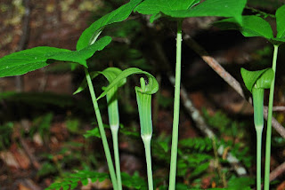
Jack in the pulpit (Arisaema triphyllum) is an unusual flower that grows from a corm.
Great blue herons (Ardea herodias) feed in the shallow waters along the shoreline of Falls Lake.
Double-crested cormorants (Phalacrocorax auritus) are common around the lake.
Ospreys (Pandion haliaetus) hunt for fish in the lake and build large nests in treetops.
Blog Entries:
25-Apr-2020: Osprey at Blue Jay Point
External Links:
Wake County Parks website: https://www.wake.gov/departments-government/parks-recreation-open-space/all-parks-trails/blue-jay-point-county-park
Go Ape website: https://www.goape.com/location/north-carolina-raleigh-durham/


No comments:
Post a Comment