
Contract Information:
Visitor Assistance Center
U.S. Army Corps of Engineers
11405 Falls of Neuse Road
Wake Forest, NC
Phone: (919) 846-9332
Email: falls@usace.army.mil
Falls Lake Dam is located between North Raleigh and Wake Forest. From I-540 in North Raleigh, take exit 14 for Falls of Neuse Road. Turn left to go north and drive 2.7 miles and turn left onto Falls Management Center Road. There is a parking area right at the turn or go 0.8 miles to the Visitor Center. To reach the Tailrace Area at the dam, continue on Falls of Neuse another 0.5 miles and turn left onto (Old) Falls of Neuse Road. Drive 0.4 miles and turn left into the Tailrace Area immediately before the bridge over Neuse River.
The map below shows the trails surrounding the dam.
There are about 2 miles of trail around the dam, but the Falls Lake Trail, part of the statewide Mountains-to-Sea Trail, continues for another 60 miles. Much of the trail passes through Butner-Falls of Neuse Game Land, so where blaze orange when hiking during hunting season. The area immediately around the dam is a safety area where no hunting is permitted.
Length: 0.5 miles
Blaze: Blue Circle
Surface: Natural
Blue Dot Trail is a half-mile spur of the Falls Lake Trail that forms a 1.5-mile loop when combined with it. Blue Dot Trail goes left from Falls Lake Trail right after it leaves the gravel road in the first half-mile. In about 0.3 miles, the trail crosses the entrance road and Long Leaf Trail then runs through an area where long leaf pine are being re-established. The trail terminates at Falls Lake Trail in a half-mile.
Visitor Assistance Center
U.S. Army Corps of Engineers
11405 Falls of Neuse Road
Wake Forest, NC
Phone: (919) 846-9332
Email: falls@usace.army.mil
Directions:
Falls Lake Dam is located between North Raleigh and Wake Forest. From I-540 in North Raleigh, take exit 14 for Falls of Neuse Road. Turn left to go north and drive 2.7 miles and turn left onto Falls Management Center Road. There is a parking area right at the turn or go 0.8 miles to the Visitor Center. To reach the Tailrace Area at the dam, continue on Falls of Neuse another 0.5 miles and turn left onto (Old) Falls of Neuse Road. Drive 0.4 miles and turn left into the Tailrace Area immediately before the bridge over Neuse River.
Map:
The map below shows the trails surrounding the dam.
Trails:
There are about 2 miles of trail around the dam, but the Falls Lake Trail, part of the statewide Mountains-to-Sea Trail, continues for another 60 miles. Much of the trail passes through Butner-Falls of Neuse Game Land, so where blaze orange when hiking during hunting season. The area immediately around the dam is a safety area where no hunting is permitted.
Blue Dot Trail:
Length: 0.5 miles
Blaze: Blue Circle
Surface: Natural
Blue Dot Trail is a half-mile spur of the Falls Lake Trail that forms a 1.5-mile loop when combined with it. Blue Dot Trail goes left from Falls Lake Trail right after it leaves the gravel road in the first half-mile. In about 0.3 miles, the trail crosses the entrance road and Long Leaf Trail then runs through an area where long leaf pine are being re-established. The trail terminates at Falls Lake Trail in a half-mile.

Falls Lake Trail:
Length: Approximately 60 miles (1 mile to second intersection with Blue Dot Trail)
Blaze: White Circle
Surface: Natural
Falls Lake Trail is a 60-mile trail along the southern shore of Falls Lake from the dam to Eno River in Durham. The eastern trailhead is at the Falls Tailrace Area below the dam. Falls Lake Trail is part of Segment 10 of the statewide Mountains-to-Sea Trail (MST). Segment 11 of the MST continues eastbound along the Neuse River Trail, part of the Capital Area Greenway. The trail follows a gravel road for a short ways then turns left into the woods. Blue Dot Trail splits to the left. The trail then crosses the dam road and passes through a field before going back into the woods. After crossing the entrance road, turn right to follow the paved Long Leaf Trail a short ways then go down the wooden steps and back to natural surface. In under a quarter-mile, cross another road and then the other side of Blue Dot Trail meets up. Falls Lake Trail continues from here towards Raven Ridge Road. See Falls Lake Trail Section 1 Hike for a description of the trail.

Long Leaf Trail:
Length: 0.75 miles
Blaze: None
Surface: Paved
Long Leaf Trail is a three quarter mile paved trail that starts at the parking lot on Falls of Neuse Road and follows the entrance road to the visitor center. It passes an area where long leaf pine are being replanted.

Unmarked Trails:
There are several miles of unmarked trails, access roads and firelines that are open to hiking.

Hikes:
Hikes at Falls Lake with detailed descriptions:
- Falls Lake Trail Section 1 is a 3.5-mile (one-way) hike leading from the dam to Raven Ridge Road and is the easternmost section of Falls Lake Trail.
Lake History:
Construction of the lake was decades in the making - the state of North Carolina first requested a study of a potential reservoir in the 1930s. In 1963, the Army Corps of Engineers recommended construction of the lake to Congress and it was authorized with the Flood Control Act of 1965. Throughout the 1960s and 70s, land was purchased, roads were raised or dead-ended, and land was cleared. Construction of the dam began in 1978 and was completed on February 26, 1981. The lake reached is normal level for the first time on December 7, 1983. Recreation areas were built throughout the 1980s and 90s and are still continuing today. Although the Army Corps of Engineers owns the land surrounding the lake, most is leased to state or local agencies and the corps manages the dam and area immediately around it.
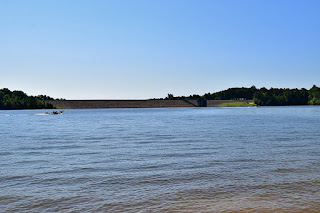
Falls Lake Dam:
The Falls Tailrace Area is at the base of the dam and you can see the outflow from here.

Here's a video of the dam during high release after Hurricane Florence.
You can see the upstream side of the dam from behind the visitor center.

Other Areas:
The Army Corps of Engineers leases out most of the land around the lake to other state and local agencies to manage as public recreation areas.
Butner-Falls of Neuse Game Land:
Most of the land around the lake is leased to the state and managed by the North Carolina Wildlife Resources Commission as Butner-Falls of Neuse Game Land. Most of the Falls Lake Trail runs through the game land where hunting is permitted, so wear blaze orange during hunting season.

Falls Lake State Recreation Area:
NC State Parks manages several recreation areas on the lake as Falls Lake State Recreation Area with opportunities for camping, swimming, boating and hiking.

Blue Jay Point County Park:
Blue Jay Point County Park is a Wake County Park on a peninsula jutting out into the lake with hiking, picnicking, environmental education and ziplining.

Forest Ridge Park:
Forest Ridge Park is a Raleigh Park on a peninsula on Falls Lake north of the dam.

Penny's Bend Nature Preserve:
Penny's Bend Nature Preserve is a protected area managed by the North Carolina Botanical Garden. The preserve protects a unique bend in the Eno River upstream of where it feeds into Falls Lake and supports rare plant communities.


Wildlife:
The forested land around Falls Lake is actively managed to support wildlife and recreation through prescribed burns and other forestry techniques. See Falls Lake Forests for more information on the forests and the species found in them.
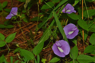
A large number of wildflowers grow around the lake. See Falls Lake Wildflowers for some of the species that can be found.

The forests around Falls Lake are a great place to look for mushrooms. See Falls Lake Mushrooms for some of the ones that can be found.

A red-tailed hawk (Buteo jamaicensis) eating a squirrel.

External Links:
US Army Corps of Engineers website: https://www.saw.usace.army.mil/Locations/District-Lakes-and-Dams/Falls-Lake/
Friends of the Mountains-to-Sea Trail website: https://mountainstoseatrail.org/
No comments:
Post a Comment