Penny's Bend Nature Preserve is a small 85-acre natural area in northeast Durham that is owned by the
Army Corps of Engineers as part of
Falls Lake and managed by the NC Botanical Gardens. The nature preserve protects a peninsula of land that is surrounded on three sides by the Eno River just upstream of where the river flows into Falls Lake. The peninsula is composed of a diabase sill, a much harder and erosion-resistant form of rock than the surrounding sedimentary rock. The flow of the Eno wore down the surrounding rocks, but went around the diabase sill, thus forming the peninsula. The diabase sill produces a unique soil type characterized by high pH (basic) as opposed to the typically acidic soil of the Piedmont. This unique soil type allows a variety of rare plants to grow in the nature preserve, not normally found in the
Research Triangle region. The history of the area dates back to 1836, when Duncan Cameron built a sawmill and grist mill on the northeast end of the peninsula near where the river now flows under Old Oxford Highway. Frequent flooding on the Eno required continual repairs to the mill. Duncan's son Paul Cameron commissioned a survey of his properties in 1890 and the peninsula in the Eno River on his Snow Hill property was designated Penny's Bend. It's probably a family name but the true origins of the name are unknown.
Directions:
GPS: 36.07334, -78.86329
From I-85 in Durham, take exit 177 for NC-55 west and almost immediately bear right on US-501 North/Roxboro Road. Go just under 1.5 miles and turn right on Old Oxford Road. In just over three miles, turn left on Snow Hill Drive just after crossing the Eno River. The parking area will be immediately on the left.
Map:
Trails:
Cash Point Trail:
Cash Point Trail leads from the parking lot across an open meadow in the middle of the preserve and then down to the river, about half-way through the Pyne Trail. The trail passes by Cash's Point, the highest point in the preserve.
Natural Heritage Trail:
Natural Heritage Trail is a short trail that runs from the northwest corner of the preserve to Cash Point Trail. Along the way, the trail passes Little Blowing Rock, a rock outcrop over the Eno River.
Pyne Trail:
Pyne Trail is the longest trail in the preserve at just over a mile. The trail runs along the peninsula from the parking lot the northwest corner of the preserve, following the Eno River for the length of the trail. The Pyne Trail is part of
Segment 10 of the statewide
Mountains-to-Sea Trail as it passes through Penny's Bend. Eastbound, the MST departs Penny's Bend from the parking lot, crosses Old Oxford Highway and picks up Section 23 of the
Falls Lake Trail. Westbound, the MST splits from Pyne and Natural Heritage Trail in the northwest part of the preserve and continues following Eno River upstream towards
River Forest Park.
Points of Interest:
Little Blowing Rock
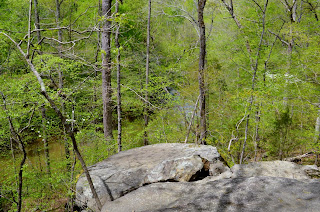
Little Blowing Rock is a rock outcrop towering over Eno River. The views are best in winter and spring before the leaves bud out. The outcrop is located off Natural Heritage Trail just up from the splits with Pyne Trail.

Wildlife:
Wildflowers:
The unique geology and soil of Penny's Bend supports a variety of rare plant life, making this one of the best places in the Triangle to view wildflowers. See
Penny's Bend Wildflowers for some of the species that can be found here.


No comments:
Post a Comment