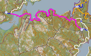
Section 14 of the Falls Lake Trail is 4.7 miles from Baptist Road at Rolling View Recreation Area to Jimmy Rogers Road. As an out-and-back hike, it's 9.4 miles round trip or half that for a shuttle hike.
Length: 4.7 miles (shuttle)/9.4 miles (out and back)
Estimated Time: 2 to 3 hours
Difficulty: Moderate
Location: Butner-Falls of Neuse Game Land and Falls Lake State Recreation Area
Trail Users: Hiking only
Dogs: Must be on a leash
Features: Lakes, Creeks, Forest,
Crowds: High
Warnings: Part of the trail passes through game land where hunting is permitted. Wear blaze orange during hunting season.
Trailhead GPS: 36.00404,-78.72802 (Baptist Road) / 36.01323,-78.77771 (Jimmy Rogers Road)
Directions:
Section 14 trailhead is along Baptist Road, just before entering Rolling View Recreation Area. From Durham, head east on NC-98 for 4.8 miles past US-70 and turn left on Baptist Road. Go 4.0 miles and turn turn left into a small parking area just before entering Rolling View Recreation Area.
To arrange a shuttle, head back on Baptist Road and turn right on NC-98 west. In 0.7 miles, turn right at the stoplight on Patterson Road and drive 2.7 miles to Jimmy Rogers Road. Turn right and go 0.4 miles to a right hand curve in the road at Little Rogers Road. Park in the curve.
Map:
Click here for an interactive map of the entire Falls Lake Trail.
Hike Description:
The trailhead is just outside the entrance to Rolling View Recreation Area, with a blue-blazed spur trail connecting to Falls Lake Trail. Because there is a fee to enter Rolling View at times of the year, the parking lot allows hikers to access the trail without paying admission. The spur trail crosses the road and leads to Section 13. See Section 13 Hike for more description. At the end of the parking area, the spur trail runs the other way about a half-mile to its intersection with the main trail. Turn left onto Mountains-to-Sea Trail and leave state park land at an old road. The trail then passes above an intermittent stream that has a small waterfall after a heavy rain.
The trail gets very close to private property in this area, so be sure to follow the blazes to stay on public property. At 3.3 miles, the trail turns onto a private gravel road.
Stay on the trail here. Go right to cross a small tributary on the road then right again back into the woods. At about 3.6 miles, there is the remains of a couple old cars just off the trail.
The final stretch of this section runs through the woods to a powerline clearing and then comes out at a gravel road leading to the bidge over Little Lick Creek. There was a gap in the trail at the end of Section 14, where a burned-out bridge over Little Lick Creek prevented passage from Section 14 to Section 15.
The new bridge was built in late 2011/early 2012 and as of February 2012, crossing Little Lick Creek is possible, so the entire Falls Lake Trail can be hiked without a six-mile detour around this area. Across the bridge, a long boardwalk traverses shallow water leading to the eastern trailhead for Section 15. See Section 15 Hike to extend the hike.
Blog Entries:
23-Jan-2021: Falls Lake Trail to Little Lick Creek
07-Jan-2018: Frozen Falls Lake
29-Jan-2017: Little Lick Creek
External Links:
Mountains-to-Sea Trail website: https://mountainstoseatrail.org/the-trail/segments/falls-lake-day-hikes/fallslake-dayhike-12/


No comments:
Post a Comment