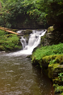
We parked at the Douglas Trailhead in a light rain. Across the street, we followed a path up along Sun Pond Creek. Right away, we came to Lower Laurel Falls, a nice 15-foot sliding waterfall.
I hopped around the creek to get some photos from different angles.
Then we continued a short ways further up the creek to Laurel Falls, a 30-foot sliding waterfall in two sections.
With all the rain from Hurricane Henri, it was looking really nice.
I climbed up the side to get some pictures of the top.
Then we headed back down. We drove about another mile up Old Mine Road and pulled over where Big Tocks Creek flowed under the road. Big Tocks Creek Falls was just upstream of the road.
It was so close to the road, it was hard to get a picture as it was overgrown with vegetation as well.
After a picture or two, we took off.
We continued up the road, entering Delaware Water Gap National Recreation Area. Our next stop was at Van Campens Glen. The yellow-blazed Van Campens Trail followed the creek upstream. It was about a quarter-mile to Lower Van Campens Falls.
The view from the trail would be pretty nice, but there was a lot of downfall. So I crossed the creek to get some pictures of the falls from close up.
Just upstream of the waterfall was a very scenic cascade.
It was another quarter-mile to Upper Van Campens Falls. The waterfall consisted of an upper drop and lower slide into a deep pool. It was raining pretty good by this point, but a very nice waterfall.
I continued up the trail a short ways to check out the upper drops. It was hard to get a good photo without getting too close to the edge.
Then we made our way back.
Our next stop was Buttermilk Falls. Mountain Road was closed, so we parked before the gate and began hiking down the road. It was about 2 miles on the road, but pretty easy.
It was raining lightly most of the way but a few showers. There were some nice flowers blooming along the road.
Lots of thistle and some wild bergamot.
In 2 miles, we made it to Buttermilk Falls, one of the highest waterfalls in New Jersey and really beautiful.
The water tumbles down over beautiful mossy rocks.
On the hike back, we got off the road and followed an unnamed tributary upstream to Silver Spray Falls.
This was another really spectacular waterfall though there were a lot of logs down at the base.
After some pictures, we headed back to the main road. With all the rain, the frogs were out in full.
It was about 1.5 miles back to the car from here.
Our last waterfall stop was near Newark and we were heading into the heavy rain of Henri. We got off the interstate in Paterson and parked at Paterson Great Falls National Historical Park.
Great Falls of the Passaic was really flowing in the rain. It was worth getting drenched to see the falls and we weren't the only ones who wanted to see the falls in the heavy rain.
After some pictures, we got back on the highway.


No comments:
Post a Comment