Showing posts with label Cheoah Ranger District. Show all posts

Sunday, September 15, 2024

Drive through Nantahala Gorge

Sunday, we went into town for a great breakfast at Everett Street Diner.  After breakfast, we headed west on US-74 through the Nantahala Gorge.  Our first stop was at the Nantahala Outdoor Center.  We walked across the street and down to Nantahala Falls.


The river release hadn't started and the flow was very low.  It's fun to paddle over when the water is higher but not much of a waterfall.  Then we went back up to the bridge and went down past the railroad tracks.  I think the road is closed and we couldn't make it to Townhouse Falls.


We could get a view of Wesser Falls from just past the bridge.  In the low water, this one looked nicer.


Then we took off and continued up through Nantahala Gorge.  We turned on FR-422/Winding Stairs Road, crossing the twin bridges over the river and then steep, bumpy climb up the road.  It was about 3 miles to a viewpoint of Queens Falls.


The view from the road in summer isn't great and I think all the land is private property.


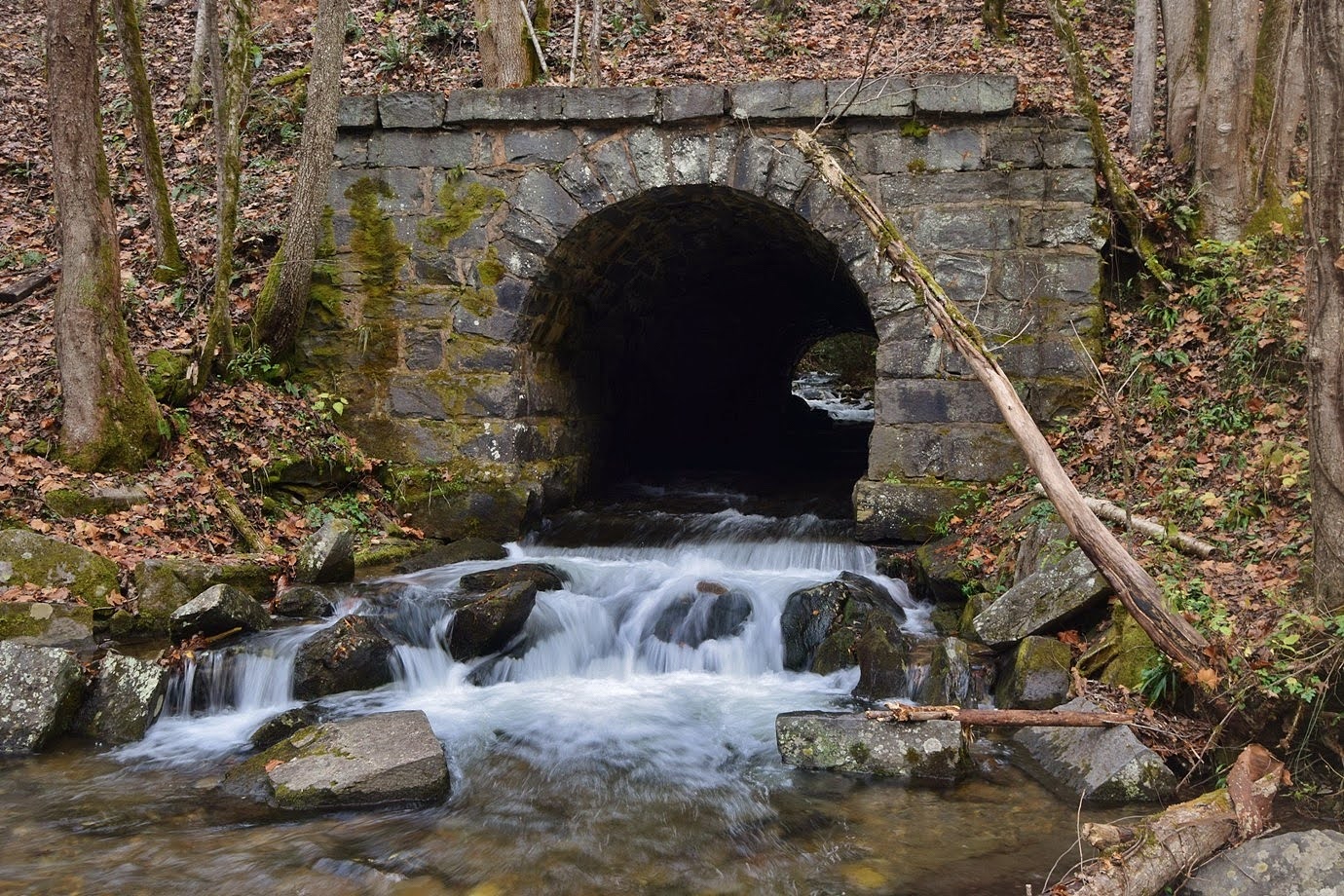
So we headed back down the mountain and parked at a small area on the other side of the road.  A short trail led up across the railroad tracks and crossed Bartram Trail to Findley Falls.


This small waterfall on Ledbetter Creek is easy to reach, especially with a baby.  All the other waterfalls are much, much harder.


We let Harper crawl around a bit and then headed back.  We continued to Wayah Road and headed up and stopped at a nice drop on Nantahala River.


A fisherman was in the river but it would have been difficult to get down, so we continued to a parking area just a couple hundred feet up the road at the Cascades of Nantahala.


A short paved pathway provided nice views of the cascades.


We then continued to Old River Road and parked at the bridge over Whiteoak Creek.  Heading back across the bridge, Jagged Rock Falls was right across where Old River Road split from Wayah Road.


In low water and summer foliage, it wasn't too impressive but did have a lot of wildflowers blooming around it.


There was some thistle blooming along the river.


We then made the short hike to Whiteoak Falls.


I first climbed up to the pool at the base and rock-hopped out for a picture.  But I liked the view from further downstream better.


Then we headed back and drove just a short ways further up Old River Road to another parking area that was right at the top of Nantahala Cascades.


A short scramble path led down to the base.


It looked like there used to be stone steps but they had washed away.


We got some pictures and then climbed back up.


There were some wildflower blooming along the road here.


Driving back, we made one more stop to see a heron at the top of Whiteoak Falls.


Then we headed back to NOC to get lunch at River's End.  After lunch, we took Needmore Road into Needmore Game Land and turned on Big Dog Road, pulling over in a quarter-mile at the top of Rattlesnake Falls.


I didn't see a reasonable path down to the base and it really didn't seem worth it anyway.


There was some butterfly bush blooming along the road.


Driving back, we stopped at the Needmore Road Suspension Bridge.


There were nice views of Little Tennessee River and the wobbly bridge led to a gravel road on the other side.


Then we headed back to Bryson City and enjoyed the nice hot tub at our cabin.

Sunday, November 1, 2020

Slickrock and Sand Creek

Sunday morning, we woke up and had breakfast then headed on US-129 into Nantahala National Forest.  Just before the bridge over Calderwood Lake, we turned left on Ike Branch and parked on this short road.  Beyond the gate, it became Slickrock Creek Trail as it entered Joyce Kilmer-Slickrock Wilderness.  Initially, the trail led along a ridge above the lake.


In under a mile, the trail crossed Ike Branch and there were some small cascades on this little creek.


The creek loses a lot of elevation, but its too small to have a waterfall.  At the Slickrock Creek arm of the lake, the trail turned away from the lake and eventually dropped down to Slickrock Creek.  Above the lake, the creek was very rocky and wild and there were numerous scenic cascades.


This part of the trail, following close to the creek, was very scenic.


In just under three miles, the trail came to a crossing.  With the water level way up this weekend, it was a deep wade.


Across the creek, we were now in Cherokee National Forest in Tennessee.  It was just a short ways further on this side of the creek to Lower Falls.  Just before, there was a little waterfall on a tributary.


We then had to climb down from the trail and use a downed tree to get over to the base of the falls without getting our feet wet.


Lower Falls was really pretty in high water.  Although only about 15 feet high, it was very powerful.


We had a snack down here while enjoying the view then made the hike back.


Next, we headed towards the Cherohala Skyway but got on FR-81 to follow Santeetlah Creek upstream.  In about 6 miles, we parked just before the bridge over Sand Creek.  We hiked up FR-81E for a short ways until it switchbacked away from the creek and then followed a very overgrown path.  There was a collapsed bridge over a small tributary and then a more difficult crossing of Wolf Laurel Branch.


The path continued about another half mile and from here it was mostly a steep bushwhack up to the base of Sand Creek Falls.


A tall, sliding waterfall, I thought it was pretty impressive in high water, but there was a lot of clutter obstructing the view.


There also wasn't much of a spot to sit and relax so we got a couple pictures then headed back.  Before leaving the area, we made a quick stop on FR-81F.  With most of the leaves down, we could see the waterfalls on Cold Branch.  Since there wasn't much time, we only scrambled down to Lower Cold Branch Falls.


It was looking very nice in the high water.


But it was getting late, so after a couple pictures, we scrambled back up to the road.


From here, we headed back to Robbinsville for dinner and then went to bed.

Saturday, October 31, 2020

Nantahala Gorge Waterfalls

For Halloween this year, we headed to the mountains for some scary difficult waterfalls.  We left super early and got to the Nantahala Outdoor Center to attempt Townhouse Branch Falls but looks like it is closed to public now.  So we headed up the river and parked at the access for Bartram Trail heading to the Cheoah Backcountry Area in Nantahala National Forest.  Ledbetter Canyon flowed under the railroad tracks here and the little bridge was scenic.


A path from the picnic area led across the tracks and to the Bartram Trail.  Instead of getting on the trail, we went straight to start following Ledbetter Creek upstream.


There were a lot of cascades and small falls all the way up the creek.


With the water level very high, we had to go around some cascades by climbing way up then had to head back down to the creek.


As we got closer to the creek, we came out at Inside Passage Falls.  There was significant water flowing through the passage, preventing any chance of climbing up through it, which we needed to continue upstream to Ledbetter Canyon Falls.


We then tried climbing the steep cliffs to see if we could get around the passage but it was just to steep, so we decided not to risk it.  Heading back, we got on Bartram Trail and started a steep climb up the ridge.  Near the top, an overgrown road to the left split off and descended to Handpole Branch.  The road petered out but it was an easy bushwhack to the top of Handpole Branch Falls.  A side stream flowed in with a nice 12-foot waterfall at the confluence with Handpole Branch.


From here, we made the extremely steep descent on river right side to a viewpoint 50 or so feet down.  The view was mostly obscured by rhododendron.


The waterfall keeps going down, but it was so difficult getting here, we didn't descend any further.  The climb back up was equally strenuous and difficult.  We finally made it back to the top then back to Bartram Trail.  Sandy spotted a grizzly spur-throat grasshopper along the trail.


Continuing on, the trail descended to Ledbetter Creek where we had to wade in high water.  Shortly after, was another crossing where we had to wade again.  There were more nice cascades along Ledbetter Creek up here.


Then we crossed some side streams before reaching Bartram Falls.


In high water, it was very scenic though rhododendron blocked the view from the trail.  The top of the waterfall was very interesting, but the lighting was poor.


I also climbed down to the base, but way to overgrown for any view of the falls.  After some pictures, we made the hike back.


From here, we drove to Robbinsville and checked into the Quality Inn and went to bed after a very long day.