The cable is too high to be of use and the crossing was very deep and swift. I scrambled upstream to a small cascade above the crossing and carefully crawled across. The water has been low, so I don't see how this is possible in even normal water levels. But I finally made it across. The second crossing was right after and wasn't as bad.
The trail then climbed up through an area that had been blasted for the logging grade and then the third crossing. This was also pretty tough and I had to scramble on the boulders.
All three of these had cables strung across that were way too high to be of use. I think maybe they're the remnants of the old logging railroad maybe. The trail then followed the creek on river right side with some scenic cascades.
It's about ten feet and nice, but probably wouldn't be worth the difficult crossings if the bigger one wasn't upstream.
I headed back to the trail and right where it passed the top of the lower falls, another side path led down to the base of Dennis Cove Falls.
Back on the main trail, it got really overgrown past the waterfall spur. But it wasn't beautiful wildflowers this time, just rhododendron and dog hobble. There were another five fords to cross as well, all requiring wading. Unlike the first three, it was fairly shallow but no rocks. I don't think the water level is ever low enough to rock hop the many fords on this trail. After the eighth crossing, FR-50F came in from the left. I followed this road up to the parking area past the gate. A side trail led to Little Laurel Fork and Firescald Branch Falls.
This waterfall has three main sections. The lowest section was just a short ways from the parking area.
This waterfall would definitely have looked better with higher water, but coming in from Laurel Fork would mighty difficult.
But it's possible to drive to this one. I climbed back down and hiked the road back to Laurel Fork Trail and continued on. After the next ford, I came to Frog Level, a cleared area for wildlife.
There was another ford and then Lacy Trap Trail split to the right. After two more crossings for a total of twelve, a short scramble path led down to Upper Laurel Fork Falls.
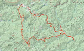
Glad it was worth all those water crossings. On the way back, to make a loop and avoid the fords, I took Lacy Trap Trail, which headed steeply up.
The first part of Lacy Trap followed an old road for about two miles, then spit onto a single track and continued up to the Appalachian Trail.


No comments:
Post a Comment