Estimated Time: < 1 hour
Difficulty: Moderate
Location: Dennis Cove Recreation Area (Watauga Ranger District of Cherokee National Forest)
Trail Users: Hiking only
Dogs: Yes
Features: Waterfalls (1)
Crowds: Low
Warnings: The rocks around waterfalls are slippery. There is no trail to the waterfall and the path is steep and overgrown, but very short.
Trailhead GPS: 36.24690,-82.08714
Waterfall GPS: 36.24748,-82.08684
Directions:
From Elizabethton, head south on US-19 E for about 5 miles to Hampton and turn left on US-321 south. Go 0.8 miles and turn right on Dennis Cove Road. Drive 6.8 miles on this road, which turns to gravel and becomes FR-50. Turn right on FR-50F (Frog Level Road) and go 2.1 miles on this very narrow gravel road to a small parking at the end. High clearance is recommended for FR-50F.
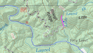
Map:
Hike Description:
Beyond the parking area, the road fords Little Laurel Fork and is gated just past the ford. Just before the ford, an obvious path leads up along Little Laurel Fork and to the lowest section of Firescald Branch Falls in a hundred feet or so.
An overgrown and steep, but obvious path continues up along the river-right side. The next section is just above this one.
Continuing up past this section, leads to this drop.
I think there may some more drops further up, but I didn't go any further. Here's a video of the falls.


No comments:
Post a Comment