Sunday, November 29, 2020

Neusiok Trail South

Sunday morning, I woke up just before sunrise and walked down to the river for a gorgeous view of the sun coming up over Newport River.


Sandy had to be at work in the evening, so we packed up camp right away and made the short drive just outside the campground to the southern trailhead for Neusiok Trail.  The trail ran along the marsh where Mill Creek drained into Newport River.


There were boardwalks over swampy parts, but some were a little sketchy to cross.


After crossing Mill Creek road, we soon came to Blackjack Lodge shelter.


There were some beautiful pine barrens gentians blooming here.


The trail continued for a ways through the piney woods.


We went as far as Alligator Tram Road (FR-124) and then turned back.


With an early start, we made it back to the car before 1130 and got home with plenty of time for Sandy to make it to work.

Saturday, November 28, 2020

Neusiok Trail Hike

Saturday morning, we woke up and had breakfast then headed to the trailhead for Neusiok Trail along NC-101.  The Neusiok Trail, part of the Mountains-to-Sea Trail, runs through the eastern portion of Croatan National Forest, from the Neuse River to Newport River.


The northern section has been closed since Hurricane Florence, so we hiked south.  The trail traverses through dense coastal forest and most of it is a real jungle.


Bushwhacking is not an option.  About three-quarters of a mile from the road, a short spur led to Dogwood Camp shelter, one of three shelters for primitive camping along the trail.


A marbled orb weaver spider had made his web at the shelter.


Continuing on, there were a few little ponds along the trail.


When we came out to Forest Road 147, we ran into a large group of hunters.  The trail followed the road for a while and it started raining, so we headed back.


From here, we drove back to Atlantic Beach and headed out for another walk on the beach.


It was another beautiful day on the beach.  We walked east on the beach to just past the pier and then headed back.


We had enjoyed Idle Hour the night before, so had dinner here again.  Then one more run out to the beach just before sunset.


Then we headed back to the mainland.


We stopped at a couple gas stations and Food Lion in Newport, but no one had firewood.  So we just went back to Oyster Point and burned a fire log before going to bed.

Friday, November 27, 2020

Croatan Forest Hikes

On Black Friday, we left Raleigh to #optoutside on the coast.  We left in the morning and first stopped at Cedar Point Recreation Area in Croatan National Forest.  Here we hiked the scenic Tidelands National Recreation Trail.


The trail was a mix of natural surface and boardwalks through forest and over the beautiful tidal marshes along the mouth of White Oak River.


There were blue Juniper berries on the red cedars.


In contrast, the yaupon holly had bright red berries - both are a winter food source for birds.


Turning right, we hiked the longer loop.  The boardwalks had arches to allow paddlers to go under.


There was a viewpoint at the far end of the loop where Dubling Creek flowed into White Oak River.


At another overlook a little further, the creek really opened up and we could see Swansboro in the distance.


We saw a great egret out in the shallow waters.


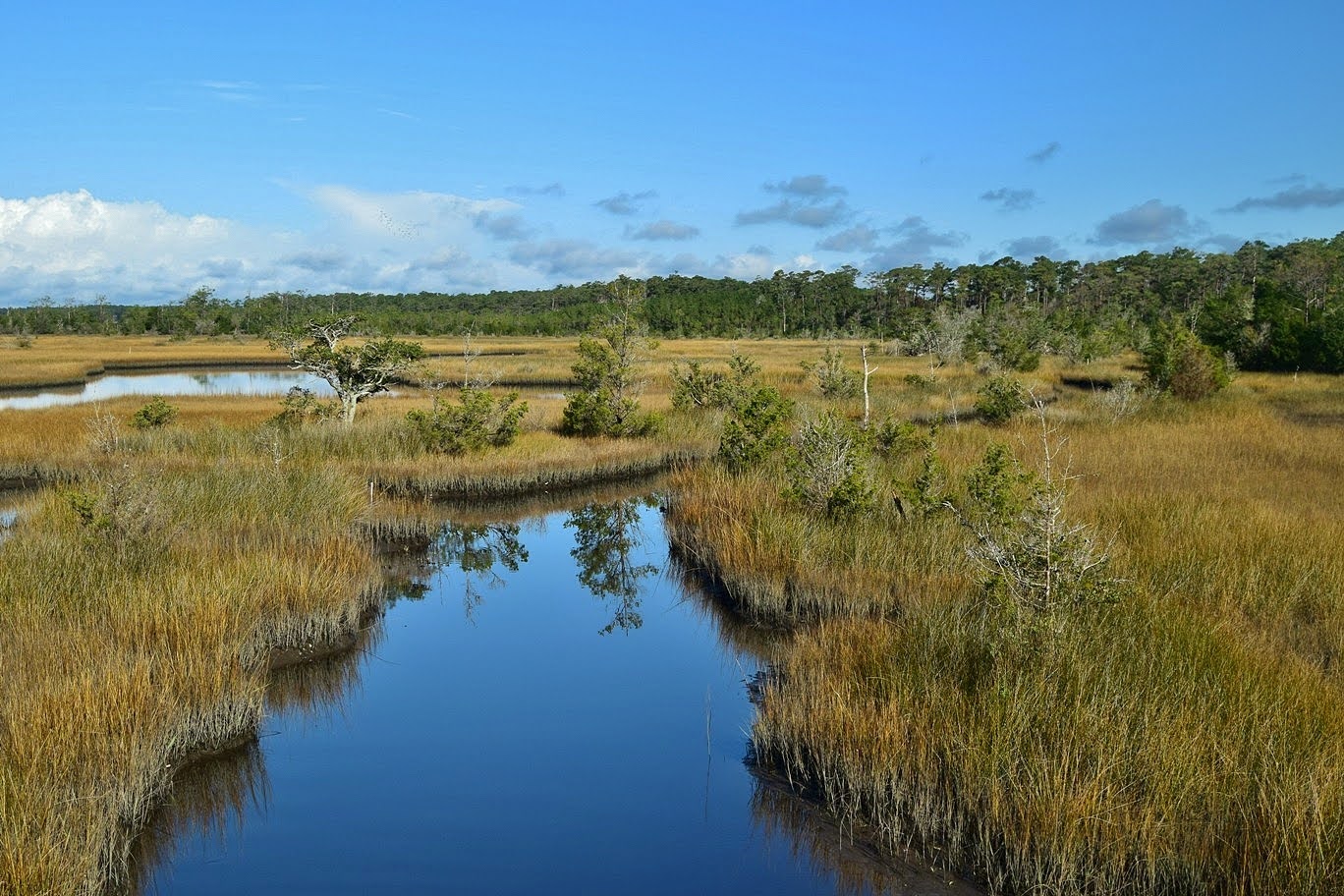
The salt marsh here was really beautiful.


On the way back, I went out on the short loop boardwalk to finish the double loop.


Then we returned to the car and headed on.


Our next stop was at Patsy's Pond between Cape Carteret and Morehead City.  The trail is a collaboration between the forest and the NC Coastal Federation.  A series of three loop trails lead through the longleaf pine flat woods.


Bob's sinkhole was right at the start.


Hiking the loop counterclockwise, we passed a few smaller unnamed ponds and Lily Pond.


Then we came to the larger Patsy's Pond.


The Yellow Trail made a big loop around the pond and through the longleaf pine flatwoods.


One pine in particular was contorted and growing almost in a knot.


On the hike back, we took a detour on the Blue Trail to hike along the south side of Patsy Pond.


There were some beautiful views of the pond from here.


This trail then looped back to connect up with the combined trails and headed back to the trailhead.


From here, we drove to Atlantic Beach and stopped at Hoop Pole Creek Preserve, another Coastal Federation property.  The trail started out as boardwalks through a dense maritime forest.


Lots of live oaks growing here, with their twisting branches a testament to the difficulty of living by the sea.


Some shining sumac was still showing brilliant fall colors.


We also spotted some more yaupon holly berries.


The boardwalks ended shortly and turned to a paved trail.  A spur crossed a small dune and led to a view of the salt marsh.


The main paved trail continued out to where Hoop Pole Creek flowed into Bogue Sound.


It was a really nice area and we took a short break out here.


We got some pictures then headed back.


We were getting hungry by this point and stopped at Idle Hour Biergarten near the boardwalk for dinner.  They have very dog-friendly outdoor seating.  After dinner, we took Alex for a short walk on the beach.  It was very pretty in the evening light.


Then we headed back to the mainland and to Oyster Point at Croatan National Forest.  Although we had a reservation, our site was occupied.  We spoke with the campground host and arranged for us to have a different spot so the other people wouldn't have to move.  The other site was just as nice as the one we reserved.  We set up camp and made a small fire before going to bed.

Tuesday, November 3, 2020

Caney Fork Waterfalls

Tuesday morning, we checked out of the hotel and started heading east.  Near Cullowhee, we headed into the Caney Fork area of Nantahala National Forest and drove to the end of Sugar Creek Road.  We hiked across the bridge and followed the road up to a creek crossing.  In high water, we had to wade and it was very cold.  The road continued up to a switchback where we followed a path up towards the Sugar Creek Falls.


The path came out at the base of the falls.


We could see Dryland Laurel Branch Falls from here, but the view was somewhat obscured.


I took off my boots again and waded Sugar Creek to get a better view.


Then we climbed up the river right side of Sugar Creek Falls to the top.  There were some nice cascades just above the waterfall.


Some old paths followed the creek upstream to the upper falls.  There were more nice cascades just below.


There were a lot of rhododendron here, but some flagging tape led through the thickets to the base of Upper Sugar Creek Falls.


I climbed up the side to view from up top.


We had a snack here and then started making our way back, managing to find a way to rock hop Sugar Creek and avoid the wade.


Our next stop was up Moses Creek Road at a switchback in FR-4651.  A path in the switchback led upstream along Moses Creek.  There were some nice cascades on the creek down below.


In about 0.6 miles, we had to wade the creek.  The trail then followed an old road high above the creek.  After a mile, we had to wade West Fork Moses Creek.  Right after crossing, a path to the left led upstream to the base of Moses Creek Falls.


The lighting was poor, but its a nice waterfall.  And it keeps continuing up the creek.


We headed back to the road and continued to a sharp switchback and went left to climb high above West Fork Moses Creek.  At the top was the uppermost section of the waterfall.


There was a lot of waterfall in between the upper and lower sections, but it would have been very difficult to get down, so we just started heading back.


Back at the car, we started making our way home.