Saturday, July 8, 2017

Sunflowers on the Neuse

Saturday, it was really hot in Raleigh, so I tried to get an early start for a hike on the Capital Area Greenway to see the sunflowers.  I drove to the Auburn-Knightdale Road parking for Neuse River Trail and headed eastbound.  Neuse River Trail starts right along the river but then heads away.  The trail came to Brown Field Road and I went right and followed to the intersection with Old Baucom Road and went left.  The trail followed this road for over half a mile to the sunflowers, which were in peak bloom.


This area is the site of Raleigh's Neuse River Wastewater Treatment Plant.  To dispose of biosolids, the solid waste residual from wastewater treatment, the city applies them to the land.  As they are rich in nitrogen, the sunflowers are planted to prevent run-off into nearby streams and creeks.  The sunflowers are certainly beautiful to look at, but they serve another purpose - the seeds will be harvested to produce biofuels.


I got a few pictures here and then continued on the trail.  It headed back into the woods, which was a relief as it was getting really hot.  The trail crossed Mial Plantation Road, where the parking lot was already full.  I went about a half-mile into Johnston County and then turned back.  It was really packed by the sunflowers on the return hike - I guess everybody knows about this now.


Tuesday, July 4, 2017

Independence Day at Chimney Rock

For Independence Day, I headed to the Hickory Nut Gorge area for a few more waterfalls before heading home.  After checking out, I took I-40 east to Asheville and then took US-74 Alt towards Lake Lure.  My first stop was at Chimney Rock State Park.  Being a holiday, I knew the park would be crowded, so I got there shortly after opening.  When I arrived, the Hickory Nut Falls Trail was closed due to a downed tree on the trail.  Fortunately, park staff were working to clear it, so I headed up towards Chimney Rock first.


I first took the Outcroppings Trail up to Vista Point with nice views of Lake Lure and the gorge.


Then I headed over to the grotto.


Next, I went through the Subway.  It was very low clearance and I had to duck to get through.


My next stop was Pulpit Rock, another nice overlook below Chimney Rock.


There were real nice views of Hickory Nut Gorge with the morning clouds still lingering.


From here, I had the bulk of the stairs to climb to get up to Chimney Rock.  The elevator has been out for a while, but I would have hiked anyway.  It was hot and humid and so all the stairs were really strenuous.  Finally, I made it up to Chimney Rock, the park's namesake with great views of Lake Lure.


Just across, I could see the Opera Box inside the cliff face.


And with the US flag flying high, it was a great scene on the 4th of July.  After some pictures, I headed up to the Opera Box, that had a very low ceiling.


But it was really pleasant in here as it seemed much cooler.  It also provided really great views of Chimney Rock.


Next I headed up for a view of the Devil's Head, and balanced rock that really resembles a face from the viewpoint.


Then it was just one more spot up to go.  I followed Exclamation Point Trail to its namesake overlook.  This spot has the best views looking west into the Hickory Nut Gorge.


Later this year, I think they're going to open Skyline Trail, which continues to the top of Hickory Nut Falls, but it wasn't open yet.  So I started heading back, stopping by Vista Rock for a nice view of Lake Lure.


By the time I got down to the parking area, Hickory Nut Falls Trail was re-opened, so I hiked to the spectacular waterfall.


The water level was up and this was a really nice waterfall.


The park claims the waterfall is over 400 feet, but from the viewing deck to the top is around 250 feet.  But it's a big waterfall no matter the height.


After some pictures, I started heading back.  I figured I'd go ahead and hike the rest of the park trails, so I turned on Four Seasons Trail and hiked down to the lower parking area.  There were some big rocks along the trail.  At the lower area, I hiked the interpretive Great Woodlands Adventure Trail and then back up.  It was quite steep and strenuous hiking back up.


Since I had hit all the park's trails, I departed and headed back into Hickory Nut Gorge to Florence Nature Preserve.  There's a nice parking area on US-74 Alt near Genton.  I crossed the street and got on Little Bearwallow Trail.  The trail headed down to the creek where some beautiful hostas were blooming.


There were also more rosebay rhododendron along Hickory Creek here.


Across the creek, the trail started to head up the mountain.  In three-quarters of a mile, it started to get real steep.  In a bit, I got to Little Bearwallow Falls.  Even in a weekend of high water, this was pretty much a wet rock.


I got a picture or two and continued up the trail.  In another half-mile or so, there was a spur trail up to Wildcat Rock.


I climbed up here and relaxed for a bit enjoying the great view of the gorge.  But it was a long drive home, so soon I started heading back down the mountain.


Fortunately, the traffic was really light coming home; surprising for a holiday weekend.

Monday, July 3, 2017

Middle Prong Waterfalls

Monday, I headed to Middle Prong Wilderness for some waterfalls.  I took NC-215 south past Lake Logan and right after Sunburst Campground, I turned onto Forest Road 97.  It was gated right after the ford on Right Hand Prong so I parked before the gate.  It was just under 1.5 miles, in the second switchback where I got on FR-97H, which is more of a trail than a road and becomes Haywood Gap Trail (#142) as it enters the wilderness.  In a short distance the trail passed over the middle of Little Beartrap Falls, but the view from the trail is not great.  After crossing the creek, I bushwhacked up the river right side of Little Beartrap Branch to get to the upper section of the waterfall.  It was quite tricky to get out on the rocks for a good view, but it was a pretty nice waterfall.


Back on the trail, I continued about a half-mile and got off the trail again.  The spot to get off the trail is not obvious at all, but its between two big dirt mounds and I thought I could hear Middle Prong Falls from there.  At first, it was an easy bushwhack through a relatively open area.  Then it got real steep and I had to hold on to rhododendron going down.  I kept climbing down and eventually came out at the top of
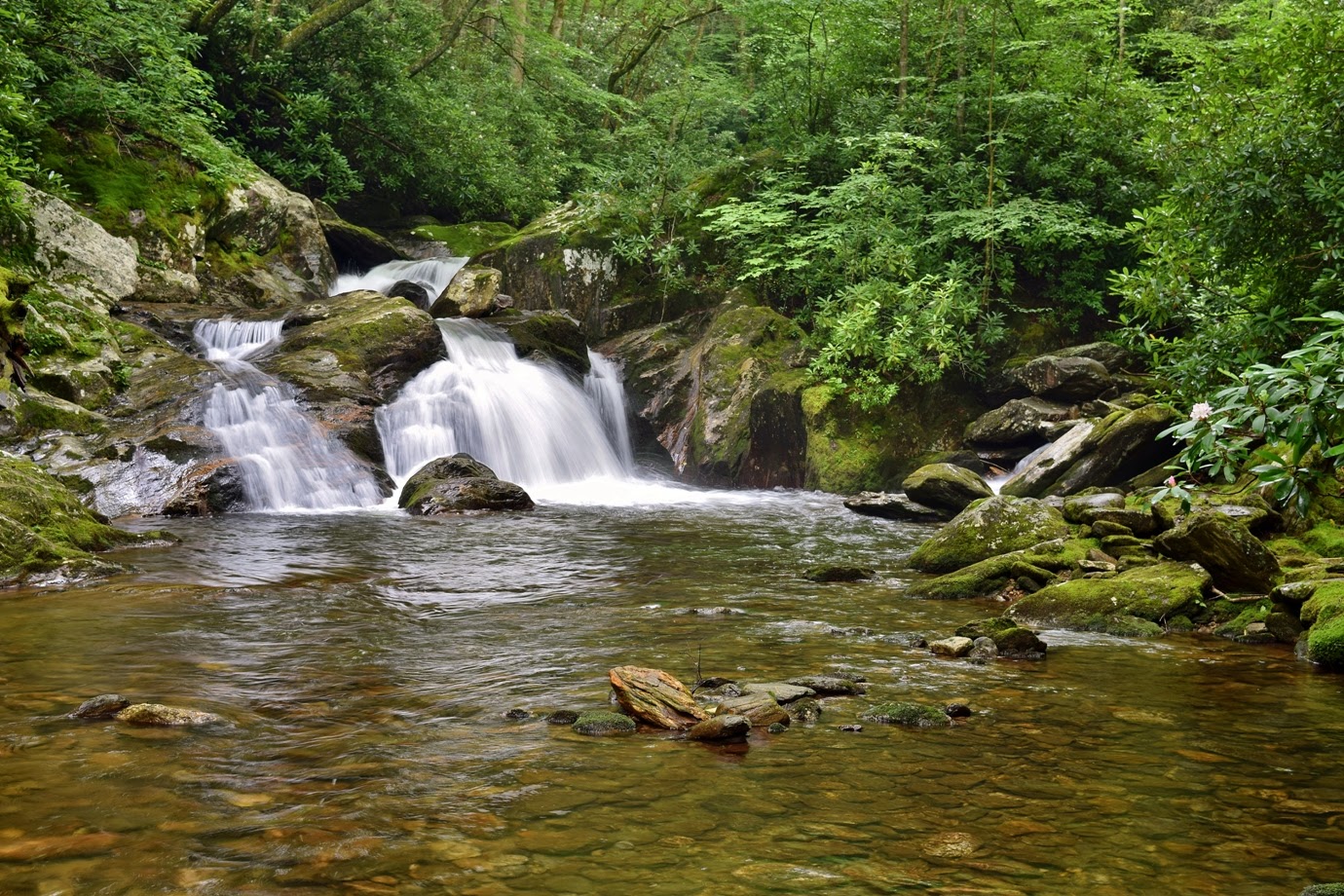
 Middle Prong Falls.


I could tell it was a great waterfall, but there was no way down from here.  So I went back up just a little and followed the cliff downstream until I could make my way down to the creek.


Middle Prong Falls was a really impressive waterfall and I spent some time enjoying the view.  The powerful water flowing generated a nice breeze that kept the bugs away and it was a bit cooler.


But I had a rough climb back up so I didn't linger too long.  I continued on FR-97H into Middle Prong Wilderness to where the trail crosses Middle Prong.  Laurie Falls is right across the river.


It's a real scenic but smaller waterfall on the river at the crossing where Haywood Gap Trail picks up on the other side.


But my destination was Big Beartrap Branch, so I had to backtrack a bit and pick up a side path that led to the creek.  From here, I needed to bushwhack up to the waterfall, but after going almost a half-mile, I couldn't find it and gave up.  I was alone and didn't want to press my luck, so I started heading back to the car.  Along the way, I spotted some beebalm blooming along the trail.


And I ran into a nice couple who gave me an Off Wipe to repel the pesky bugs.  They were really bad in here.  At the first switchback on FR-97, I followed a path to the base of the lower section of Little Beartrap Falls.  I couldn't find a good spot for that waterfall, but the next tributary over - Berry Branch - had a nice little waterfall flowing over a rock in two streams.


There were some nice cascades downstream on Little Beartrap Branch as well.


Then I headed back to the car.  Back on NC-215, I headed south for about 2 miles and pulled off where the road crosses Green Creek.  A small path on river left led a short ways to Little Bird Falls, a small, but scenic waterfall.


It was such a lush, green setting; even though the waterfall is small, the mossy rocks and vegetation made it feel like a rain forest.


I got a couple pictures and then drove a little further to the pull-off for Sunburst Falls.  First, I headed to the upper sections upstream of the road.


The rocks were wet from recent rain so I didn't scramble too high.  Then, I scrambled down below the road to see the lower cascading section below the bridge.


Usually, I don't like man-made stuff in waterfall pictures - it distracts from the natural setting.  But this bridge is so scenic, it really brings out the scene.


Back at the car, I drove a little further a pulled off on the left.  I donned water shoes and found a super steep and overgrown path down to West Fork Pigeon River.  There was some flagging tape to indicate the best way down.  At the river, I scrambled upstream a short ways to get past a cascade and then crossed the river to the base of Lower Wildcat Falls.


Although short, it's rather difficult with the steep scramble down to the river and then creek-walking up to the waterfall.  But it looked really nice, especially in high water.  On the way back, it was easier to get past the cascades on West Fork Pigeon River on the river-right side.


When I had visited Wildcat Falls, the water level was really low, so I figured I'd try to hit that one up as well.  I drove further up NC-215, almost to the Blue Ridge Parkway and pulled off at the big MST parking area on the right.  From here, I got on the MST going westbound into Middle Prong Wilderness.  The trail paralleled the road for a ways then headed west through the woods and then a field.  It continued through a muddy area and then started switchbacking up the mountain.  After the second switchback, I found a spot to get a nice view of Mount Hardy Falls from a distance.


This one is on a very small stream, but in high water like today, it was quite impressive - more like a waterfall out west.


I went a little further on the MST and then turned back.  It rained a little here and there on the hike back, but not much.  The field part of the hike was overgrown and I got really wet hiking through here.  Back at the car, I started back down NC-215, making one more stop at the trailhead for Wildcat Falls.  After parking, I hiked past the campground and rock-hopped Bubbling Spring Branch and got on Flat Laurel Creek Trail (#346).  Right away, there were some small cascades just off the trail.


With the recent rains, they looked pretty nice.  It was another half-mile or so to Wildcat Falls.


It's a small tributary, but looked a lot better than my previous visit when it was just a wet rock.


After a couple pictures, I headed back and packed up to depart in the morning.

Sunday, July 2, 2017

Bear Creek & Chasteen Creek Falls

Sunday morning, I had a quick breakfast at the hotel and then drove west to Bryson City and into Great Smoky Mountain National Park.  I followed Lakeview Drive, the "Road to Nowhere", to the end and parked at the trailhead for Lakeshore Trail.  The trail starts out on the road past the barricades and towards a tunnel.


The tunnel is really big; it's straight so I could see right through, but it was deceptively long, close to a quarter-mile.


Beyond the tunnel, the road becomes a trail and gradually headed down towards Fontana Lake.  This is a pretty remote section of the park so I didn't see too many other people along my hike.  It was about 2.5 miles from the tunnel to where the trail headed down to Forney Creek where it flows into Fontana Lake.  There was a big campsite here (#74) and a footbridge over the creek.


I got some pictures from the bridge, but then headed the other way, picking up Forney Creek Trail.  In less than half a mile, I turned left on Bear Creek Trail and crossed Forney Creek on a wide footbridge.  After crossing Bear Creek on another bridge, the trail headed towards Welch Branch and then turned sharply back towards Bear Creek.  In just under a half-mile from Welch Branch, I got off the trail and started bushwhacking down towards the creek.  I could hear the waterfall from here, but it was hard to discern as Bear Creek has many cascades and drops.  There were also some steep cliffs to navigate around and as I could close to the waterfall, it was a brutal wade through rhododendron to get out to the base of Bear Creek Falls.  But despite the difficult bushwhack down (and equally bad going back up), the waterfall was worth the effort - it was a real beauty.


I relaxed down here for a while, taking some pictures and eating a snack.  But it would be a nasty climb back out, so I didn't linger too long.  Once back at the trail, the hike back wasn't too bad, though it was mostly uphill.  Near the tunnel, I took a detour on Goldmine Loop Trail that headed steeply down to Goldmine Branch and then  to Fontana Lake.


There was a nice spot to get out and view the lake here.  I saw a couple on jet skis cruise through the little cove.  Then it was all uphill back to the tunnel.  There were a lot of Rosebay Rhododendron blooming along the trail and made for a welcome break to stop and take a picture.


Eventually, the trail leveled off and I turned on Tunnel Bypass Trail to head back.


Back at the car, I was pretty tired from the, but wanted to get another waterfall.  On the way out of the park, I stopped at the Fontana Lake Overlook for a view of the lake where Tuckaseegee River flows in.


Leaving Bryson City, I headed to Cherokee and the Smokemont area of the park.  Parking at the far end of the campground, I picked up the Bradley Fork Trail and followed its namesake upstream.  This trail is for hikers and equestrians; I saw a number of pipevine swallowtail butterflies feeding on horse waste along the trail.


In a mile or so, I turned right on Chasteen Creek Trail and went about three-quarters of a mile to a fork.  Chasteen Creek Trail went to the right, while left headed to a horse hitching post.  Just past the post, a short path led to Chasteen Creek Falls.


It's not a big waterfall, but rather scenic.  And despite being close to the Smokemont Campground, I had it all to myself.  I took off my boots and waded in the creek for a bit, as much to cool down as to get pictures.


After a little while, I headed back.


I didn't want to get stuck in Cherokee traffic again, so leaving the park, I got on the Blue Ridge Parkway.  And I couldn't help, but stop at an overlook along the way.  I pulled over at Lickstone Ridge Overlook for a nice view of Cherokee down below.


Then I returned to the hotel for the evening after a long and strenuous day.