
It's a small but scenic waterfall. I climbed down the bank to get some picture from the base and then continued on.

In another quarter-mile or so, the trail merged with Buckhorn Gap Trail (#103) and I followed the combined trails a short ways to the split, where I crossed Avery Creek on a bridge to stay on Buckhorn Gap Trail. In under a mile, I went left at the fork to get on Twin Falls Trail (#604). It was less than half a mile to the two waterfalls that make up Twin Falls - one on Henry Branch and the other on a tributary. I had visited this one before, but today there was a huge amount of downfall on the left waterfall.

It would have been very difficult to climb up to the base so I settled for a picture from a distance. I continued on to the right waterfall and climbed up the river-left side of the creek to the main drop.

There are more drops and cascades above but I couldn't get to a good position for a picture. So I started making my way back. After passing the left waterfall, a small path led upstream on the next tributary over. I could hear something so I followed this path up to another small waterfall on a tributary of Henry Branch.

There wasn't much water flowing, but it was a nice little spot. I guess a better name for the waterfall would be Triplet Falls. Continuing back, at the intersection with Avery Creek Trail, I turned right on this trail to continue following the creek upstream. In just over half a mile, a side path led down to the base of Upper Avery Creek Falls.

In the high water, I thought this was a really nice waterfall. After a couple pictures, I rested and had a snack here, enjoying the view. Then I started heading back. There were a lot of rosebay rhododendron blooming in the area, their white flowers in contrast to the pink flowers of the Catawba rhododendron.

I also spotted some pretty summer wildflowers blooming along the trail.

At the very first footbridge over Avery Creek, I went straight to get on on Clawhammer Cove Trail (#342). This trail followed Avery Creek downstream to near the confluence with Clawhammer Cove Creek and then followed this creek upstream for a little under a mile. After crossing the creek, the trail led away from the creek upstream towards a gated road. I got off the trail here and bushwhacked a short ways upstream to Clawhammer Falls.

It's only about 10 feet high, but pretty for a small waterfall. After a couple pictures, I starting heading back to the car. There were some white bergamot blooming in Clawhammer Cove.

The white flowers have tiny little pink spots. Heading back up to the road on Avery Creek Trail, there were lots of rosebay rhododendron blooming.

I took FSR-477 back to US-276 and went north, making a quick stop at Looking Glass Falls. Being roadside, this is a super popular waterfall and many people were swimming at the base.

I got a couple pictures but didn't stay long as it was too crowded. Driving just a short ways further, I stopped at the trailhead for Moore Cove, another popular spot. Moore Cove Trail (#318) is a pleasant 3/4 of a mile hike to Moore Cove Falls.

Just before, the waterfall, I turned left and crossed Moore Creek and crossed a small tributary just past the campsite. Turning right, I followed a path upstream a short ways to Little Moore Cove Falls.

This waterfall is nearly identical, but half the size of Moore Cove Falls.

It's also a lot less well known - there were at least a dozen people at Moore Cove Falls, but I had this one to myself.

After a couple pictures, I headed back to Moore Cove Falls for a couple pictures, but it was quite crowded so I didn't stay long.

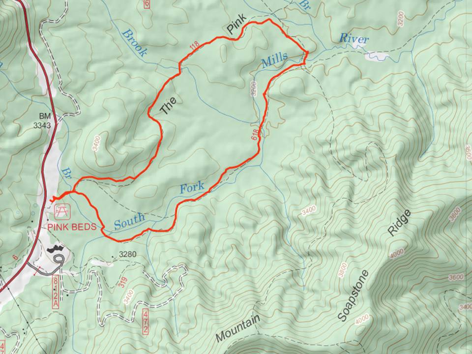
It was starting to get late, but I wanted to get one more hike in, so I continued on US-276 up to the Pink Beds Picnic Area. After parking, I got on the Pink Beds Loop Trail (#118) and began hiking the loop. The entire loop is 7 miles and it was getting late, so about half-way through, I turned on Barnett Branch Trail (#618) to bisect the loop. There were a lot of rosebay rhododendron along here and it was a very pleasant hike.

As I got closer to the picnic area, the land became more swampy along the South Fork Mills River - a unique high-altitude Appalachian bog. There were several boardwalks through the swampy area.

With cutting the loop in half, it was just over three miles for the loop and I made it back to the car a little after 6.
After my hike, I continued on US-276 past the Blue Ridge Parkway and then back down the mountain to Canton and checked into the Quality Inn. I had fast food for dinner and took a shower and then pretty much passed out as I was exhausted from the day's adventures.
No comments:
Post a Comment