Showing posts with label Horsepasture River. Show all posts

Saturday, July 24, 2021

Tight Squeeze at Windy Falls

Saturday, we woke up and had breakfast then drove to Gorges State Park. We took Raymond Fisher Trail to Chestnut Mountain Road and went a short ways to an old road on the left that entered Toxaway Game Land and descended down towards Horsepasture River. There were some cool golden spindle mushrooms growing along the trail.


In about 1.5 miles, the road ended at the river just above Windy Falls. There was a nice cascade just above, but it was hard to see around the rocks.


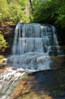
We climbed a little further and found another really nice cascade flowing around a big rock.


Then we started heading down along Windy Falls. The path was fairly easy to follow though steep in places. I managed to step on a hornet’s nest and got stung, not the best place for it. 


Soon we got to a steep ridge that was wet and probably too difficult to go down unaided. So we tied off a drop for the steep descent and would need it heading back up. Down from here, we came to a big rock near the base of Windy Falls. To go any further, we needed to squeeze through the keyhole. Sandy got stuck in the keyhole and was a little panicked. It looked like it might rain soon, so we decided not to risk it and headed back. 


By the time we got back to Chestnut Mountain Road, it was raining pretty heavily, so glad we turned back


It was still pretty early, so we headed into Pisgah National Forest to the Avery Creek Trailhead off FR-477.  We followed Avery Creek Trail (#327) for about a half-mile as it passed the top of Avery Creek Falls.


A short scramble path led down to the base of the falls.  I thought it looked pretty nice even in lower water.


There were a whole bunch of spring azure butterflies down here.


We climbed back up to the trail and continued following the creek upstream.  There was a mushroom that looked like a bagel.


In a little over a mile, a steep path led down to the base of Upper Avery Creek Falls.


We got some pictures and then hiked back.


We stopped at Ecusta Brewery and got dinner from the food truck and had drinks at the brewery.  After dinner, we returned to camp and made a fire before bed.

Saturday, October 12, 2019

Gorgeous Gorges

Saturday, we left early to take Alex to the mountains for a long weekend of camping and waterfalls.  Our first stop was the visitor center at Gorges State Park to get Alex's passport stamped.


Then we parked at the Rainbow Falls trailhead and began our hike along Horsepasture River.  The trail leaves Gorges State Park and enters Pisgah National Forest in under a mile and begins to follow the river more closely.  Soon we made it to Rainbow Falls.  Even in low water, the waterfall is spectacular.


We climbed down to the base for a good view of this magnificent waterfall.  There was a little rainbow at the base.


Continuing along the trail, next up was Turtleback Falls.


In the summer, it's too crowded with swimmers but today it was looking nice.


From here, we followed the trail to the end of the national forest property.  Drift Falls is on private property but can be seen from the property line.


This was our turnaround point.  Just past Rainbow Falls, I scrambled down to the river for Hidden Falls.


And shortly before we got back to Gorges State Park, we took a side path down to Stairway Falls.


In low water, it didn't look as much like stairs.  After a break, we headed back up to the trailhead.


Heading back on US64, we parked immediately across the bridge over Toxaway Falls.  Carefully crossing the highway, we got behind the guardrail and went east to an old gated road.  The road petered out after a bit but it was pretty easy following the path.  Flagging tape helped us stay on the path down to Toxaway River.  Following the river downstream, we came out at the top of Twin Falls.  A rope assisted with the climb down to the base.


Twin Falls is a really nice waterfall, I was impressed.


And Toxaway River was really scenic going downstream.  After some pictures we made the climb back up.  Before crossing US64, I scrambled down to Toxaway Falls.  I made it to the top of the big drop.


With condos across the gorge, it wasn't a great view.  Getting further down would have been tough, especially for Alex so we headed back to the car.


From here, we drove to Lazy J's and set up camp.  Sandy spotted a food truck at Headwaters outfitters to save us the drive to Brevard.  We had barbeque from the food truck and drinks from the taproom with Alex.  Before returning to camp, we made a short detour on Diamond Creek Road.  Diamond Creek Falls is a roadside waterfall a mile and a half up the road.


It was obscured by rhododendron and wasn't much of a view from the road.  We headed back to camp and built a campfire for a bit before going to bed.

Saturday, October 8, 2016

Sidepocket and Paw Paw Falls

Last weekend, Sandy and I headed to the mountains for some waterfalls.  It was a good weekend to get away as Hurricane Matthew was making a lot of rain around Raleigh.  Out in the mountains, though, the weather was pretty nice – mostly blue skies with some wind gusts.  We left early and headed out to Gorges State Park, arriving around 10.  We parked at the Grassy Ridge Trailhead and hiked down Rainbow Falls and Raymond Fisher Trails.  In a quarter-mile, we turned left and continued on the blue-blazed Raymond Fisher Trail to Chestnut Mountain Road.  Turning right, we followed the 4WD road just a short ways to a big pile of gravel.  A small path led from behind the pile and headed towards Horsepasture River and eventually became more of an overgrown road.  This road eventually leads to the top of Windy Falls.  In about a quarter-mile, a second old road came in from the left and just past where the two roads converged, we got off the trail and bushwhacked towards the river.  There was enough of a trail and flagging that it was pretty easy to follow.  We went between two small knolls than up a ridge and then steeply down to the river.  Near river level, we found a scramble path that led upstream to the base of Sidepocket Falls.


We found some rocks at the base to sit and eat lunch and get some pictures of the lower section of the falls.  I thought the lower section was more scenic than the upper section.  After we ate lunch, we scrambled up the rocks to see the upper section.  We got about half way up and then had to climb across some down trees to get up for a view of the upper portion of the waterfall.


After a couple pictures, we returned the way we came.  Climbing up from Horsepasture, we were able to switchback a bit more to avoid some of the steepest sections.  Back at Chestnut Mountain Road, we turned right on Raymond Fisher Trail and followed it down to the pond and campground.  At the campground, we followed a service road past the campsite to a junction and made a sharp right.  Hiking down another old road, we made a left at the next two intersections and then forded Bearwallow Creek.  Once across the creek, we bushwhacked downstream following the creek closely.  Our plan was to visit the four waterfalls that make up Paw Paw Falls, all four of which now have their own names.  There were some cascades and small drops and then we came to Indian Camp Falls, the first of the four, about a quarter-mile from the ford.


We could see the waterfall from an angle, but for a good view, I had to wade the creek and climb onto the rocks directly across from the waterfall.


It was a cool setting for the falls with the creek making a 90-degree turn at the base of the waterfall.  Just below this waterfall was Split Rock Falls, where the water tumbles down a split in the rock face.


From here, the bushwhack got very difficult.  Cliff faces made us have to go high above the creek to proceed downstream.  Eventually, we were able to get back down towards the creek and came out at Chute Falls.  This was my favorite of the waterfall on this short run of Bearwallow Creek.


Unfortunately, a big tree had recently fallen down right in front of it and the foliage prevented getting any good pictures.  We crossed the creek here and bushwhacked down to Paw Paw Falls.  I dropped my phone somewhere along the way and had to run up and get it.  It was starting to get late so I didn’t bother to go back for a picture.  We then bushwhacked up the ridge and eventually came out on the road before the ford.  We followed the same route back and took Chestnut Mountain Road back to the parking area.  As we got back to the parking area, we talked to a ranger on an ATV, who must have known we were bushwhacking by how tired and dirty we were.  He asked if we had gone to Windy Falls, so I told him about our adventures for the day.  Then he took off and we headed to our hotel in South Carolina for the evening.  Passing by Lake Keowee on the way, we saw a beautiful sunset.


Sunday, June 28, 2015

Turtleback Falls

Sunday morning, we woke up and broke camp. After saying good-bye to all our friends, Sandy and I headed to Gorges State Park. At the visitor center, we turned left and drove to the Bearwallow Falls parking area. After getting ready, we hiked the short Bearwallow Falls Trail to the overlook for the waterfall. Unfortunately, with all the foliage, the view of the waterfall isn’t that great.


We saw a faint path heading down past the wooden overlook, so we followed it to try to find a better view. It was quite steep and we had to hold on to rhododendron branches to get down. We came out at a spot at the base of a 15-foot or so cascade over several rock ledges.


This part of the waterfall is just below the part we could see from the overlook, but we couldn’t see anything above it. We decided to give up and try again another time. So we headed back to the car and drove to the Rainbow Falls trailhead parking area. We hiked down the trail and of course had to stop at the beautiful Rainbow Falls. A small rainbow was visible right at the base, but it was too late in the day for a better rainbow.


We then continued on to our main destination for the day – Turtleback Falls. The water level seemed a little higher than normal, but not too high. I was a little concerned, however, as no one else was sliding off. It seemed like everyone was waiting for someone else to go first. Finally, a teenager defiantly walked over to the rope, climbed up and slid off the waterfall. He ended up getting in trouble and wasn’t allowed to swim anymore, but I was glad someone went first. Seeing that it was safe to walk over to the rope, I waded over and climbed up the waterfall and then slid off. It had been several years since I had the chance and it was a lot of fun.


The water was quite cold, but the rush of sliding off a waterfall kept me from noticing at first. After a couple runs, I was starting to really get cold so I got out of the water. Sandy ended up not sliding – she claimed it was too cold for her. So once I was done, we headed back to the car and started making our way home. We stopped at Las Salsas in Morganton for dinner and had a huge portion of fajitas, a fitting end for another epic Big Brevard trip.

Wednesday, October 22, 2014

Back to Brevard

Wednesday morning, we woke up early, had breakfast at the hotel and checked out. We would be meeting Justine, Bill, and Grace in Brevard, but since they were driving from Raleigh, we had a little time to kill. So we headed to Gorges State Park for a quick hike along Horsepasture River. We had been to the waterfalls along here many times, but never during fall foliage, so this would be a great spot to wait for our friends to join us. We hiked the moderate Rainbow Falls Trail (#499) into Pisgah National Forest for about 1.5 miles to the beautiful waterfall.


Surprisingly, there was no one else here (and yet we had seen someone at Dismal Falls the day before!). The fall foliage surrounding the waterfall was gorgeous, the best fall color we had seen yet. And there was even a nice rainbow, adding more color to the scene!


Amazingly beautiful...this was definitely worth the detour. We spent some time here, enjoying the beautiful falls and rainbow and made a quick run up to Turtleback Falls before heading back to the car.


The foliage along this stretch of Horsepasture River was absolutely beautiful.


But we couldn’t spend too long as we had to meet our friends and had more waterfalls to get. So we hiked back to the car, passing several groups of people heading towards the waterfalls.


I guess we weren’t the only ones who wanted to visit this falls today, just the earliest to arrive. Back at the car, we left Gorges and headed back to Brevard. We stopped at Subway again to get our lunches for the next couple of days and then met our friends at Davidson River Campground, where we would be camping tonight. After setting up our tents, we headed north on US-276 and turned onto Forest Service Road 477 (Avery Creek Road). In about 2.5 miles, we came to a pulloff under some power lines and started hiking on Buckhorn Gap Trail (#103). Some incredibly mature person defaced the first letter on the trail sign to form a profanity. The orange-blazed Buckhorn Gap Trail leads about 2 miles to the waterfall. It’s also an equestrian trail and there were several spots where the trail fords a creek, but log bridges were available to cross without wading. After about two miles, we took the Twin Falls Trail (#604) to the waterfall. Although there are two falls, it’s not possible to see both at the same time.


We first went to the one on the left (on Henry Branch) and had lunch here. This is definitely the more impressive of the two.


We climbed around at the base of the falls and got some pictures, before heading to the other one (on an unnamed tributary of Henry Branch). The water level was not that high and this one was mostly obscured by foliage and downfall.


We got a couple pictures and then started making our way back to the cars. Once back, we drove back to US-276 and continued north. Past the Cradle of Forestry, we turned right on Forest Service Road 1206 and then another right on FSR 476 and followed this to the end. We parked here and set off on our last hike of the day to see High Falls on South Fork Mills River. We started off on South Mills River Trail (#133) for about a mile to concrete bridge.


At this point, we got off the main trail and followed another unlisted trail that crossed Billy Branch and continued following the river. In about another mile, the trail appeared to end at the river. According to our directions, we needed to cross the river. The water level was not too high, though it was very cold, so we crossed here, expecting to pick up the trail on the other side. After wading through the frigid knee-deep water, we got to the other side, but could find nothing that looked like a trail. We bushwhacked upstream for a ways, but the going was extremely slow and it was getting late and the sun would be setting soon.


Finally, we gave up and turned around making it back to the cars right at sunset. Carefully reviewing the maps and directions, we realized that we had crossed the river at the wrong place. We needed to continue up another quarter-mile to the correct river crossing. I guess we’ll have to come back for this one. Before heading back to camp, we drove into Brevard for dinner at Twin Dragons China Buffet and then returned to Davidson River Campground. It was quite cold this night, but we didn’t even bother with a campfire.

Saturday, March 9, 2013

Waterfalls along Horsepasture

Next, we headed to Gorges State Park to see some of the waterfalls along the Horsepasture River. From the Grassy Ridge Access area, we hiked down the Rainbow Falls Trail heading out of the park and into Pisgah National Forest. Our first stop was at Rainbow Falls, perhaps one of the most beautiful waterfalls in North Carolina.


Casey and I had been here several times before, but Sandy and the others had not. It's always fun to see the look on people's faces when they see the waterfall for the first time. The water level was much higher than I'm used to seeing in the summer and the waterfall was much more powerful. The area below the falls where I have swam in the past was being pounded with falling water and swimming would have been impossible even if the water was warm enough. Even up on the trail, we were getting wet from the spray, so we didn't go down to the viewing platform to get any closer. Next, we headed up to Turtleback Falls, which was also more powerful than usual.


It was also unusual to see no one there. I've only been here in the summer and there's always a big crowd of people water-sliding down Turtleback. So it seemed strange to see it deserted.


We stopped just upstream of the falls and had lunch. After eating, we headed upstream just a short ways further to the end of the National Forest land for a view of Drift Falls.


This waterfall is on private property and no trespassing is actively enforced. But with the foliage down and a telephoto lens, I was able to get some good shots while staying on National Forest property. Then we turned around and headed back. On the way back, we stopped at two more smaller falls along the Horsepasture River. Hidden Falls is a small waterfall just downstream of Rainbow Falls.


It's not real impressive, but makes for a nice swim hole when the weather is warmer. Surprisingly, there was actually someone swimming here - he must have been freezing! Then we headed down to Stairway Falls. I've seen this one before in the summer when the water levels are lower. But today, with the water up, it looked much more like a stairway.


After we were done here, we headed back to the parking area and made a quick stop at the new Visitor Center for Gorges State Park. They had some great photos of the waterfalls in the park and interesting exhibits on the geology and natural history of the park. From the back deck, there was a nice view of the mountains and gorges to the south, including Sassafras Mountain, the highest peak in South Carolina.


Leaving the park and heading towards South Carolina on NC-281, we stopped at a pullout just before the Thompson River and headed down to see White Owl Falls, a small but very pretty and scenic waterfall. From the pullout, we crossed the street and headed back along NC-281 until the end of the guard rail and hiked down a very short but steep trail to see the falls.


Then we headed to our last waterfall for the day; and the biggest. Just before the South Carolina state line, we stopped at the Whitewater Falls day-use recreation area in Nantahala National Forest. At 411 feet, Upper Whitewater Falls is claimed to be the highest in North Carolina and the eastern US. Walking down the paved trail to the first overlook, there was a great view of Lake Jocassee to the south.


We stopped at the upper overlook then headed down the stairs to the lower overlook, which has the best views of the falls.


Actually, climbing down just below the overlook and out on some rocks provided the best views.


After a few pictures we headed back to the cars as the sun was beginning to set. On the way back to the campsite, we stopped at Hawg Wild BBQ just before entering Pisgah National Forest for dinner.