Monday, February 17, 2020

Blue Ridge Parkway MST Hike

Monday morning, we checked out of the hotel and headed to E. B. Jeffress Park along the Blue Ridge Parkway.  We got our stuff together and headed northbound along the Mountains-to-Sea Trail.  The trail followed Falls Creek down and there were some nice cascades along the trail.


Crossing a footbridge, the trails diverged and we went right towards Cascade Falls.


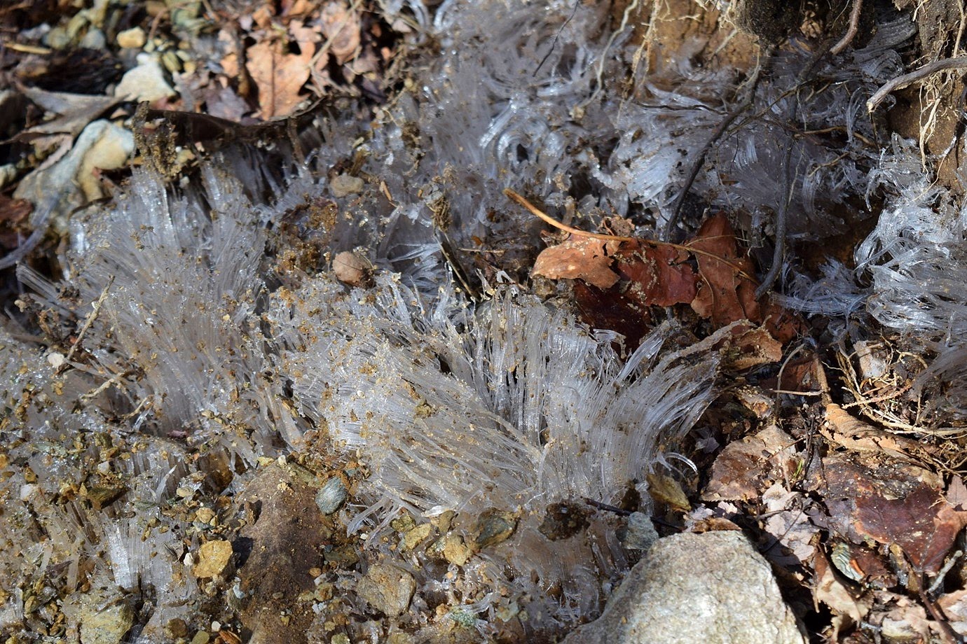
With high water and the leaves off the trees, this waterfall was looking really good.  There was some ice near the top.


The view from further down was great.


After some pictures, we headed up and got back on the MST.  Heading northbound from Jeffress Park, the trail followed along the top of a cliff.  It was very forested so the views were obscured but it was a scenic hike overall.


It crossed the parkway and climbed up, running high above the road.  A few parts of the trail were very narrow.


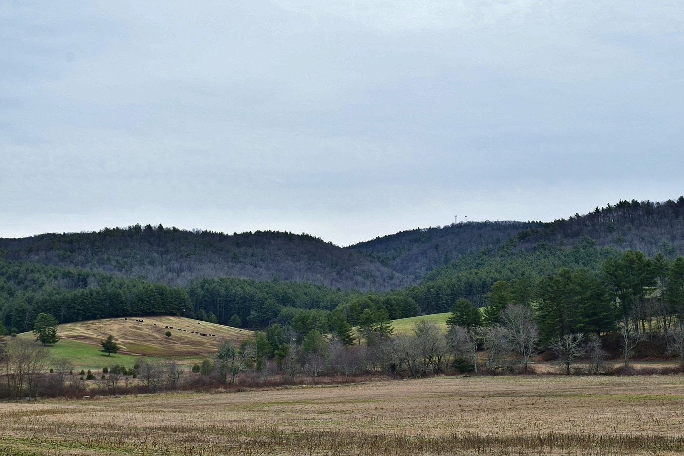
Soon, we descended to an open field where some guys were flying a model airplane.  Alex said hi to their dog and then we continued on, walking along the road a short ways before getting back on trail and climbing up.


We crossed the parkway one more time and hiked about a half-mile further and came to a nice spot for a snack break.  Then we turned back and hiked back to the car.


Driving southbound on the parkway, we made one stop at Elk Mountain Overlook.


The views from this overlook were really great and we could see Grandfather Mountain in the distance.


On the way home, we stopped in Winston-Salem at Foothills Brewery for an early dinner.  Then we drove the rest of the way home.

Sunday, February 16, 2020

Alex's Last Stamp

Sunday, we had breakfast at the hotel and then headed out.  We first made a stop at Riverview Falls on a tributary of New River.


It was looking good in the high water but no icicles as I had hoped.  Then we headed to New River State Park for Alex's last passport stamp.


We took Hickory Trail down to the river at the canoe launch.  Nice views of the river here and it was really flowing.


We followed Riverside Trail as it followed the river downstream.


As the trail departed from the river, it passed the Stump Family home site.


The house had burned down, but the chimney, root cellar and springhouse remained.


After this point, the trail got steep and headed away from the river.


Eventually, it connected back up with Hickory Trail.  We finished up the loop back to the car.


From here, we headed up to the Blue Ridge Parkway and parked at Basin Cove Overlook at the south end of Doughton Park.  From here, we hiked the Mountains-to-Sea Trail southbound, heading into the woods and descending behind the National Park Service office.


In about a mile, it came out at a gravel road and then crossed the parkway.  There were a bunch of icicles along the trail here.


One was particularly interesting.  In another mile, the trail crossed the parkway again and began following a gravel road.


We hiked the road for about another mile and then headed back.  The last part of the hike was uphill to the Blue Ridge Parkway but not too bad.


I got some pictures from Basin Cove Overlook.


Then we started making our way back to Boone.


Driving along the Blue Ridge Parkway, we made a stop at View Betseys Rock Falls.


With the leaves off the trees and the high water, this waterfall was looking really good.


It's really high!  From here, we headed into Boone and got Alex an ice cream cone to celebrate finishing the passport.


Then we got Chinese for dinner to eat at the room and started getting packed up.

Saturday, February 15, 2020

Calloway Peak

For the holiday weekend, we took Alex out to Boone to finish the State Parks passport challenge.  First, we stopped at the interim park office for Grandfather Mountain State Park to get his passport stamped.


Then we headed up to the Blue Ridge Parkway and stopped at Boone Fork parking area.  Here, we took Tanawha Trail to Daniel Boone Scout Trail and started hiking up the mountain.  There wasn't much snow at first, but some little ice formations were popping out of the ground.


In about 1.5 miles, we came to Flat Rock View.


Scrambling out on the rocks, there were great views from here.


We stopped and had a snack up here and took a short break before the climbing really started.


Continuing on, the trail got steeper and there were some nice icicles along the trail.


The trail was pretty icy and there was a dusting of snow, but not as much as we hoped.


Near the summit, we came to the ladders.


It was tricky getting Alex up this part, but he's a good rock climber.  Soon we got to the summit of Calloway Peak, the highest point on Grandfather Mountain.


The views from up here were great.  There was rime ice on the north-facing portion of the summit.


I continued on to Watauga View with more great views, including Sugar Mountain.


We had lunch at the summit then started making our way back down.  At Flat Rock, we turned on Cragway Trail to make a loop going back.


There were cool views from Top Crag and we could see Calloway Peak towering above.


The trail was rocky, but at least we were heading downhill.


Where the trail ended, a turn on Nuwati Trail led back to Tanawha Trail.  At Boone Fork, we made a turn on Asutsi Trail and hiked below the parkway.  At the trailhead on US-221, we turned right along the road a short ways to Green Mountain Falls.


The water level was high and there were a bunch of icicles along the waterfall.  There was also a lower section below the road that was quite scenic.


It was visible from the road and I scrambled down to the base for a view straight on.


After some picture, we hiked back Asutsi Trail and Tanawha Trail.  Boone Fork was scenic as we crossed on the footbridge.


It was just a short ways further back to the car.


On the way to Boone, we called in a pizza at Mellow Mushroom then checked into the Quality Inn.  We brought the pizza back to the room for dinner then went to bed early.

Saturday, February 8, 2020

Carvers Creek Sandhills

Sandy had Saturday off so we took Alex for a hike at Carvers Creek State Park.  Since our last visit, the park had opened the Sandhills access with over 10 miles of multi-use trails.  And Alex loves sandy trails.


So we headed to this new section near Fayetteville and arrived just before 9.  First, we got on the trail and went left to hike the Wiregrass Loop through a longleaf pine forest.


With recent prescribed burns, the understory was almost completely wiregrass.


Finishing the loop, we went left on Longleaf Pine Trail, the main trail through this section.  It ran along the entrance road for a ways and in about a mile, we turned left on Little Pond Spur Trail.  It was a short trail out to a scenic little pond.


We took a short break here then back to the main trail.  We crossed over Carvers Creek, which was very swampy.


After the crossing, we went right on Fox Squirrel Loop Trail.  We also took Dead End Spur Trail out to the park boundary and back.


When Fox Squirrel Loop ended at Longleaf Pine Trail, a right turn led to a bridge over a tributary of Carvers Creek.


We followed Longleaf Pine Trail to the end at Turkey Oak Trail, but turned around here.


On the way back, we took RCW Loop Trail, but didn't see any woodpeckers.


A recent controlled burn was evident.  At the end of this loop, we took Longleaf Pine Trail back to the parking lot.


On the way home, we stopped at Redneck BBQ Lab for dinner; Alex had a hot dog!