Contact Information:
9872 Hwy 105 S (Suite 6)
Banner Elk, NC 28604
Phone: 828-963-9522
Email: grandfather.mountain@ncparks.gov
GPS: 36.111200, -81.811140
Map:
Hiking:
There are 12 miles of rugged hiking trails in the state park that can be accessed from the Profile Trailhead on NC-105 or along the Blue Ridge Parkway. A free permit is required for hiking or backpacking in the backcountry and can be obtained from kiosks at the trailheads.
Cragway Trail:
Length: 1.0 mile
Blaze: Orange Circles
Difficulty: Strenuous
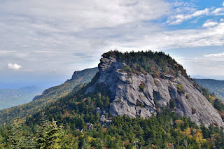
Cragway Trail makes a connector between Nuwati Trail and Daniel Boone Scout Trail. About half way along the trail is Top Crag View, a series of crags and boulders with views of Calloway Peak.
Daniel Boone Scout Trail:
Length: 3.0 miles
Blaze: White Diamonds
Difficulty: Strenuous
Daniel Boone Scout Trail can be accessed from the Boone Fork Parking Area at Mile Post 299.9 on the Blue Ridge Parkway. From the parking area, turn left on Tanawha Trail, crossing Boone Fork on a footbridge. In about a half-mile, after passing Nuwati Trail, Daniel Boone Scout Trail will be on the right. The trail climbs steeply up the eastern flank of Grandfather Mountain. In about 2 miles, Cragway Trail splits to the right at Flat Rock View. The trail gets steeper as it approaches the summit. The last section requires climbing ladders to reach the top of Calloway Peak, the highest point on Grandfather Mountain.
Grandfather Trail:
Length: 2.4 miles
Blaze: Blue Diamonds
Difficulty: Advanced
Grandfather Trail starts at the swinging bridge at the private attraction and leads across MacRae Peak and Attic Window Peak, ending at Daniel Boone Scout Trail near Calloway Peak. It is a very challenging trail with numerous cables, fixed ladders and rock scrambling.
Nuwati Trail:
Length: 1.2 miles
Blaze: Blue Circles
Difficulty: Easy
Nuwati Trail can be accessed from the Boone Fork Parking Area at Mile Post 299.9 on the Blue Ridge Parkway. From the parking area, turn left on Tanawha Trail, crossing Boone Fork on a footbridge and Nuwati Trail will be on the right. The trail follows Boone Fork upstream intersecting Cragway Trail in half a mile. The trail continues to Storyteller Rock's and a backcountry campsite.
Profile Trail:
Length: 3.1 miles
Blaze: Orange Diamond
Difficulty: Strenuous
The Profile Trail leads from the parking area on NC-105 in Banner Elk up to Calloway Gap between Calloway Peak and Attic Window, gaining about 2000 vertical feet in just over three miles. The trail starts moderate, following the upper section of Watauga River and then crossing it. The first mile is relatively flat, but then it starts to gain significant elevation. In just over a mile and a half, the trail will pass Foscoe View with nice views of the valley below. The trail then passes by the Profile, an exposed cliff below Calloway Peak. At the right angle, it resembles an old man's face, thus the name of the trail and mountain. There is a campsite right at the base of the cliff and a good view of the profile about a half-mile further.
Past the profile view, the trail passes Shanty Spring, the last reliable source of water. About a half-mile past the spring is the upper terminus of the trail at Grandfather Mountain Trail. Calloway Peak is about a half-mile to the left and MacRae Peak is under a mile heading right.
Underwood Trail:
Length: 0.5 miles
Blaze: Yellow Diamonds
Difficulty: Strenuous
Underwood Trail splits from Grandfather Trail near Grandfather Gap and bypasses the summit of MacRae Park, connecting back near MacRae Gap. The trail is steep and has fixed ladders, but is slightly less strenuous than Grandfather Trail.
Points of Interest:
Attic Window Peak:
Attic Window is one of four peaks that make up Grandfather mountain and is crossed on Grandfather Trail.
Calloway Peak:
Calloway Peak is the highest point on Grandfather Mountain at 5,946 feet above sea level. It can be reached from Daniel Boone Scout Trail or Grandfather Trail.
Flat Rock View:
Flat Rock View is located about 2 miles up Daniel Boone Scout Trail at the intersection with Cragway Trail. The flat rocks provide a nice view from nearly 5000 feet.
Indian House Cave:
Indian House Cave is a shelter cave just off Grandfather Trail just past Attic Window.
MacRae Peak:
MacRae Peak, at 5,846 feet above sea level, has great views of Attic Window and the surrounding mountains. It is accessed from Grandfather Trail and requires climbing numerous fixed ladders.
Mile High Swinging Bridge:
The Mile High Swinging Bridge accesses Linville Peak and is part of the private attraction.
Plane Crash:
The wreckage of a plane that crashed in the 1970s is just off Daniel Boone Scout Trail near the summit of Calloway Peak.
Storyteller's Rock:
Storyteller's Rock is located at the end of Nuwati Trail and provides views of Calloway Peak.
Top Crag View:
Watauga View:
Watauga View is just off Grandfather Trail right before reaching the summit of Calloway Peak and provides nice views of Sugar Mountain and the upper Watauga River.
Wildlife:
Wildflowers:
Grandfather Mountain is a great place to view wildflowers. The significant changes in elevation mean you'll see different flowers as you hike up the mountains.
One of the earliest spring bloomers are trout lilies, named for their spotted leaves that resemble trout.
Another early spring flower is the Carolina Spring Beauty (Claytonia caroliniana).
Bottle gentians (Gentiana clausa) make blue flowers shaped like bottles.
Honey mushrooms (Armillaria mellea)
Blog Entries:
06-Oct-2023: Mile High Swinging Bridge
15-Oct-2022: Cragway Fall Foliage Hike
15-Feb-2020: Calloway Peak
15-Apr-2017: Grandfather Mountain Profile Trail
External Links:
NC State Parks website: https://www.ncparks.gov/state-parks/grandfather-mountain-state-park
Private Attraction website: https://grandfather.com/


No comments:
Post a Comment