Sunday, August 7, 2016

Bernie's Falls

Sunday morning, we broke camp and headed out for one more waterfall before heading home - Bernie's Falls.


We took US-64 west to NC-281 north and drove just past Dismal Falls to a pull-off at gated FSR-5077. Hiking down this forest road, we passed a split for FSR-5077B in about a mile and FSR-5077A in about 1.5 miles. Just after this, we turned left to stay on FSR-5077 and headed down to an open area. There was a split and we stayed straight to continue through the open field, roughly following Miser Creek downstream. We had to cross the creek at one point and then a little ways later, we came to another split at a walnut tree. Turning right here, we headed back into the woods following Miser Creek downstream. Just before the trail started heading up a hill, we got off the trail and crossed Miser Creek, coming out at the top of Bernies Falls. Hiking away from the falls, we came out on an old road and turned left. At a point where the road was blocked by downfall, we turned left again on a very steep path that headed down to the waterfall. There was a nice grotto before the falls where Alex could rest while we explored around. The path led behind the waterfall on a narrow base, where I spotted some bee balm blooming in the waterfall spray.


Continuing on, the path led down to the base of the waterfall. There were nice views of the waterfall from the base, but I think the best view was from a spot roughly half way down. It was just a little tricky to find a stable spot to stop and take a picture.


After a few pictures and a snack, we started making our way back. It started drizzling on the way back, but the rain didn’t really pick up until we got back to the car. We then made the drive home after another great Big Brevard weekend.

Saturday, August 6, 2016

Shining Rock & Courthouse Falls

Saturday morning, we had breakfast and headed towards the Shining Rock area.  Heading north on NC-215, we crossed the Blue Ridge Parkway and parked along the side of the road here just a half-mile past.  We got on the Mountains-to-Sea Trail westbound here and headed into Middle Prong Wilderness.  After crossing Bubbling Spring Branch, the trail paralleled NC-215 for a bit and then turned away.  In about a mile, we came to an easy stream crossing at the confluence of two streams that formed the headwaters of West Fork Pigeon River.  At this point, we got off the trail and bushwhacked up along the right tributary to Mount Hardy Falls.  This waterfall is on a small tributary and wasn’t flowing well.


Moreover, the bright sunlight shining on the upper portion while the lower portion was in dark shadows made a good picture impossible.  I think there is a better view from further up the MST, but the conditions were poor, so we just started hiking back.  As we got closer to NC-215, we took a scramble path down to the road and walked down to the trailhead for Wildcat Falls.  Hiking past the campsite, we rock-hopped across Bubbling Spring Branch and followed the old road, which is Flat Laurel Creek Trail (#346).  Right after the stream crossing, we passed a small, but scenic cascade on a small tributary.  The cascade was in the shadow, so I could get a decent picture of this one.


Unfortunately, that was not the case with Wildcat Falls.  The water level was low and the sun was shining right on it.  A concrete bridge led over the creek in the middle of the waterfall.  A picture from the bridge was difficult because of the bright sunlight.  I climbed down below the bridge to try from there, but the bright sunlight and dark shadows from the bridge made for a lousy picture.


So we started heading back.  We took the same path up from NC-215 back to MST and just before we got back to the start, turned off the trail and followed Bubbling Spring Branch upstream.  There’s no real trail, but it’s pretty easy to follow.  We crossed the creek several times and finally just creek-walked up to Lower Bubbling Spring Branch Falls.


Then we climbed up the river-right bank and went a short ways further to Upper Bubbling Spring Branch Falls.  Both waterfalls had low flow, but the lighting was better.


And the water level was up, compared to the last time I was here, so I actually got some decent pictures. Then we headed back to the car and started driving back south on NC-215.  We turned left on Courthouse Creek Road (FSR-140) and drove about 2.5 miles up this road.  There wasn’t much parking at the trailhead for Kiesee Falls, so we drove a short ways further to a pull-off and parked here.  It started raining, so we waited for the rain to die down a bit before starting our hike.  We hiked back down FSR-140 to a curve in the road where an overgrown trail headed into the woods.  A yellow Closed to Vehicle sign indicated that this was the right path.  We followed this path for about a half-mile to a fork – the right fork led to Kiesee Falls and the left to Upper Kiesee Falls.  Since Kiesee was the harder waterfall to visit, we went right first.  Almost immediately, we had to bushwhack around rhododendron and then picked up the path again.  It became more overgrown and difficult to follow as we continued.  Finally, we got to a spot where it led down to creek.  We had to jump to get to the other side of the creek and then bushwhack upstream a short ways.  Upon getting to a small waterfall just below Kiesee Falls, the trail got really hard.  We had to first scramble up a steep cliff face.  Finally, I could see Kiesee Falls in the distance.


But there was no way to get closer.  The cliff face was wet and a small waterfall was flowing down the middle.  This part is difficult under the best conditions and it had started raining heavily when we got here.  At least I could see the waterfall, if not get a good picture, so we turned around.  Back at the fork, we turned right and followed the path further upstream.  In about a quarter-mile, when we were almost directly above Kiesee Falls, a path split to the right and led down to Upper Kiesee Falls.  The last segment was a steep section of wet rock, but after Kiesee Falls, this one seemed like a breeze.  I rock-hopped across the creek for a picture and then we started heading back.


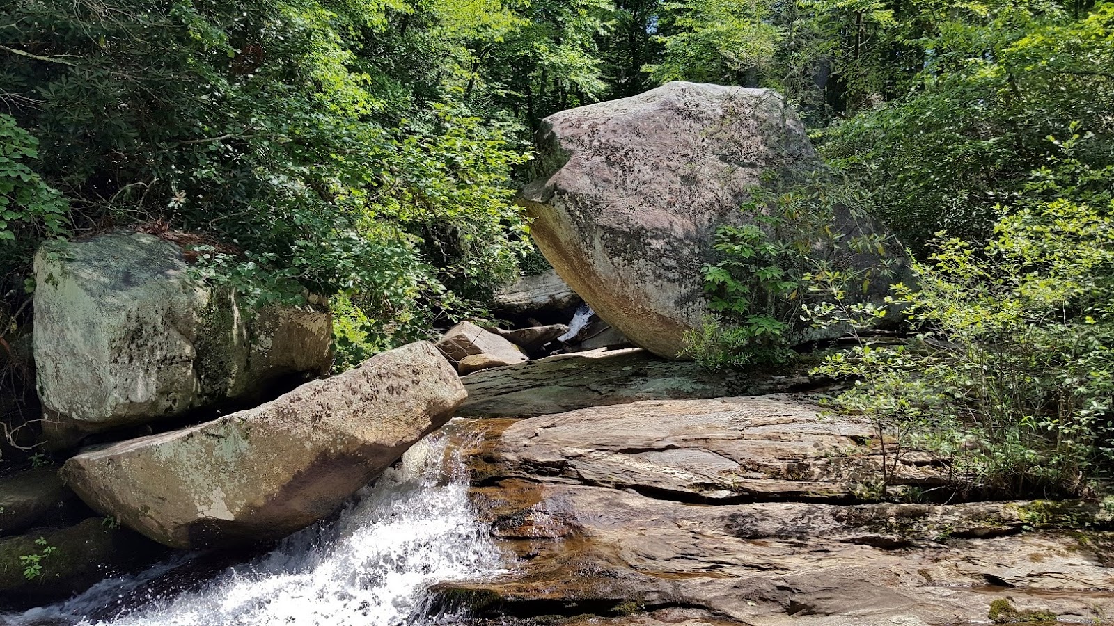
Back on FSR-140, we continued past the car to the gated FSR-5031.  We hiked along this road for just under a mile and took a side path to the left down towards Chestnut Creek.  We came out at the base of the falls and stopped for a break.


This is a really scenic waterfall and we spent some time climbing on the rocks and getting pictures.


Then we headed back to the car.  Since we were so close, we decided to get one more waterfall.  We continued a little further on FSR-140 and parked at the trailhead for Courthouse Falls.  It’s just a short hike to this beautiful waterfall.  Several groups of people were swimming in the pool at the base of the falls.  Recently, a huge tree had fallen and damaged the stairs leading to the base, but it was not too much trouble to get down.


After a couple pictures, we headed back.  We drove into Brevard and got take-out from Hawg Wild BBQ and headed into Pisgah National Forest for a picnic dinner.  Since we had Alex this weekend, we couldn’t eat inside restaurants.  After dinner, we headed back to camp.

Friday, August 5, 2016

Highlands Waterfalls & Panthertown Valley

The first weekend of August was our annual Big Brevard trip.  Sandy and I took Friday off from work and headed out early in the morning, bringing Alex the husky with us.  We drove out to Franklin and then took US-64 back towards Highlands through the Cullasaja River Gorge.  We pulled into the Cliffside Lake Recreation Area and parked at the trailhead for Ranger Falls.  Shortly after we arrived, Justine arrived and we set off on the short trail.  The trail initially headed up a moderate slope and came to a split.  A left turn here led down to Skitty Creek and then followed the creek upstream, while straight continued to Flat Mountain.  In total, it was just over a mile to the waterfall.  Although there had been a lot of rain in Highlands the past couple days, it apparently did not fall in the Skitty Creek watershed as Ranger Falls had very little water.


This was Alex’s first waterfall and my number 400!  After a couple pictures, we made the hike back to the cars.  From here, we drove into Highlands and took NC-106 south towards Scaly Mountain.  After about 9 miles, we pulled over at a School Bus sign and found an overgrown scramble path that led down.  Almost immediately, a right turn led down to the creek at the base of Upper Middle Creek Falls.


We got some pictures from the base here while Alex splashed around in the water.  Then I climbed up a rock to get a view from here.  After a few pictures, we headed back to the split and turned right.  The trail soon petered out and was difficult to follow.  A few pieces of flagging tape helped keep us on track.  Soon, we came to the top of Middle Creek Falls.  The creek flowed through some slides and there were some huge boulder here.


But we needed to get further down to see the main part of the waterfall.  We backtracked a bit and followed a path that led away from the creek and then back at a spot roughly in the middle of the main 75-foot section of the waterfall.  The water level was a little low, but the waterfall was still very impressive.


We got a few pictures and then started heading back.  Back in Highlands, we got on US-64 east and headed to Lake Toxaway.  We took NC-281 north a short ways and then turned on Cold Mountain Road.  Due to the recent rains, Shower Bath Falls was actually flowing and we pulled over for a quick picture.


Then we continued to the parking area for Panthertown Valley.  We started on the Panthertown Valley Trail (#474) and followed this trail down towards Greenland Creek.  Just before the bridge, we turned right on Devils Elbow Trail (#448).  We passed through a powerline clearing and just after that, turned off the trail at a campsite.  The short path led down to Tuckasegee River at the top of Wardens Falls.  A steep path to the right led to the base of the waterfall.


I got out on the rocks, but couldn’t really see the waterfall well.  I took off my boots and waded into the water for a better view.  Unfortunately, the water level was too high and fast-moving to get to the other side.  So I got the best picture I could and then climbed back up to the top and we started making our way back.  Back at Panthertown Valley Trail, we turned right to cross the bridge and then turned left on Little Green Trail (#485).  It was just a short ways to Schoolhouse Falls.  It was getting late so we didn’t stay long, but we couldn’t pass seeing this scenic waterfall when we were so close.


After heading back to the car, we drove to Kuykendall Group Camp and set up our tent.  Although it was Alex’s first time camping, he seemed to enjoy it.  Fortunately, it was rather cool at night so he didn’t get overheated.