
Hike Length: 0.8 miles
Estimated Time: 1 to 2 hours
Difficulty: Moderate
Location: Nantahala Ranger District of Nantahala National Forest
Trail Users: Hiking only
Dogs: Yes
Features: Waterfalls (1+)
Crowds: Low
Warnings: The rocks around waterfalls are very slippery. The path to the waterfall can be difficult to follow and getting below the main upper drop is extremely difficult.
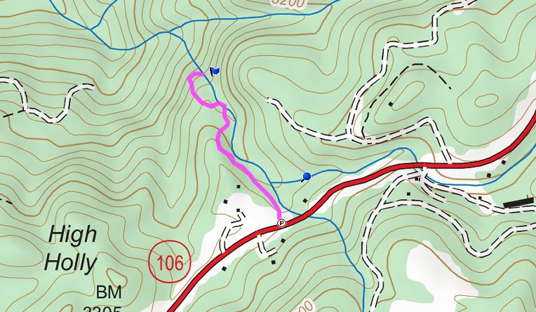
Trailhead GPS: 35.00693,-83.32907
Waterfall GPS: 35.01056,-83.33121
Directions:
From Highlands, head south on NC-106 for 9.3 miles from the intersection with US-64 to a pull off on the right side of the road at a yellow school bus sign. There is only room for one or two cars here to park.
Map:
Hike Description:
Follow the obvious path from the parking area that leads down and under some power lines to a split after a couple hundred feet. Right goes to Upper Middle Creek Falls. Go left and head up a ridge. This part is confusing with numerous side paths that go nowhere. In 0.2 miles, a trail comes in from the left. Ignore this as it goes to private property and turn right instead. In about 0.3 miles, a side path on the right goes to the top of Middle Creek Falls. There's a huge boulder up at the top but no way to get further down.

Go back 50 feet or so to the split and go right to follow the path to a view point of the main upper frop of Middle Creek Falls.

You can scramble down the rocks to a view at creek level.

The waterfall continues down but there is no reasonable way to continue further. Here's a video of the falls.
05-Aug-2016: Highlands Waterfalls & Panthertown Valley
No comments:
Post a Comment