Showing posts with label Daniel Boone National Forest. Show all posts

Saturday, September 5, 2020

Arches and Falls

Saturday morning, we had breakfast then headed to the Yahoo Falls Scenic Area of Big South Fork National River and Recreation Area.  After getting our stuff together, we started out on the trail.  An overlook where Yahoo Creek flowed into Lake Cumberland was just off the trail here.


Soon we came to a split and went left to descend metal stairs down into the gorge.  Alex did not like these stairs, but he quickly descended and came out at Yahoo Falls.


Yahoo Falls is claimed to be the highest in Kentucky at over 100 feet.


There were trails all around the waterfall.


We could walk around the base of the waterfall here and view it from different angles.


It was a nice spot to hang out and enjoy the scene.  We spotted a little mushroom growing upside down under some rocks.


Continuing on the trail, we left the recreation area and entered Daniel Boone National Forest.  It was just a short ways further to Yahoo Arch.


It was a really cool arch and we could walk underneath it and all around.


It was even possible to climb up to the top of the arch.


It was a really cool area.  We took a little break here and had a snack then started making our way back.


From here, we headed to Yamacraw Bridge and parked here to pick up Sheltowee Trace Trail again.  Following the river downstream, we saw some wildflowers along the trail.


Lots of orange and yellow jewelweed were flowering.


In under a mile, the trail passed a small tributary.  A short path led up the tributary to Julia Lynn Falls.


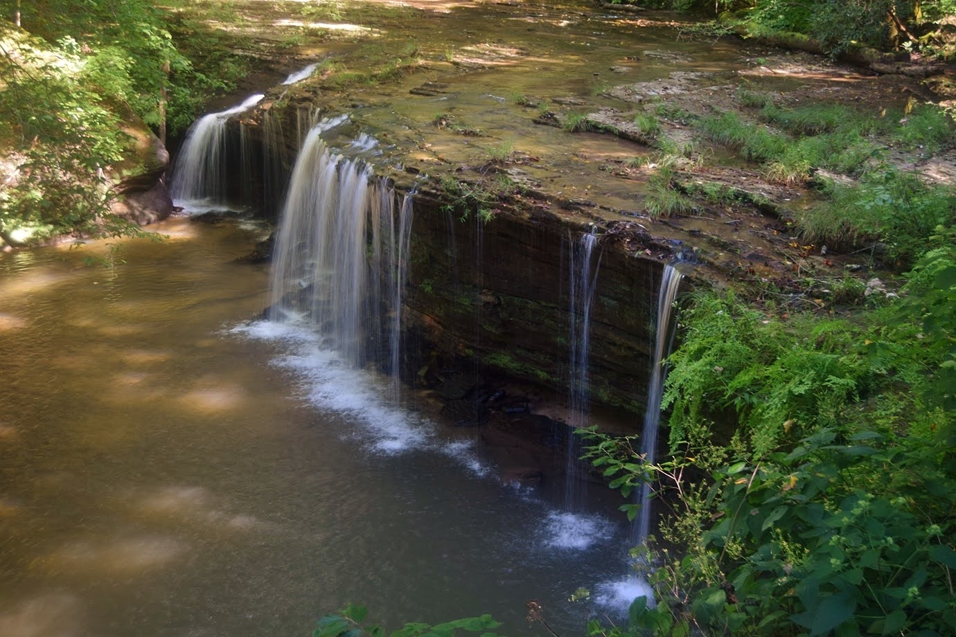
The stream was very small, but it was a scenic 20-foot overhanging drop that would probably be very nice right after a heavy rain.


Shortly past here, the trail entered Daniel Boone National Forest and came to a bridge over Lick Creek.  We went right on Lick Creek Trail (#631) and soon a path led down to the base of Princess Falls.


It was a pretty waterfall and very scenic area.


I took off my boots to wade in the creek and view the falls from different sides.


It started to get crowded so we continued on the trail, which passed right above the waterfall.


Further along the trail, we saw a cool cauliflower mushroom that resembled lasagna.


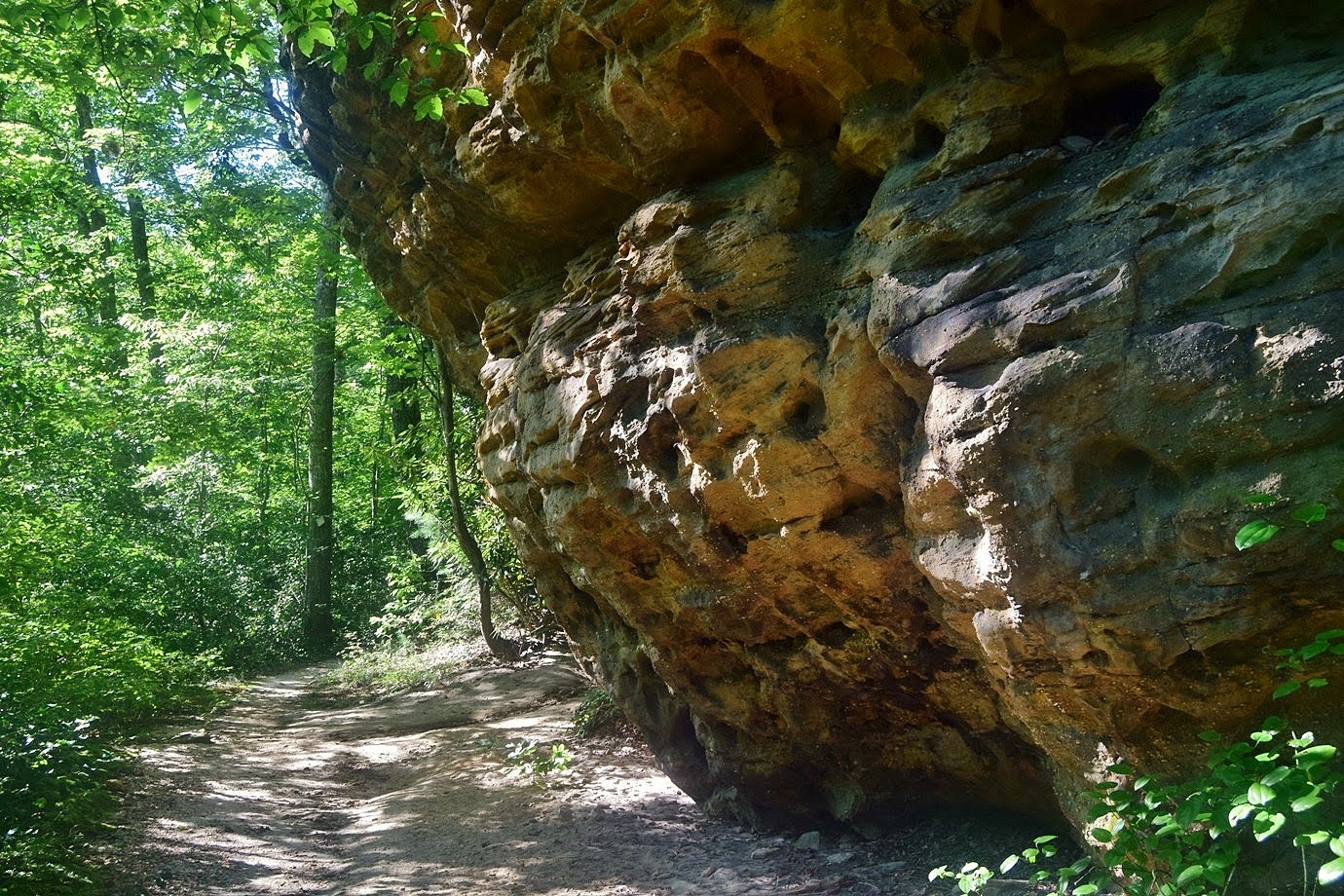
There were a couple creek crossings along the trail before we made it to Lick Creek Falls Trail (#631A).  Turning right, we followed a tributary upstream past some huge cliffs.


The trail ended at the base of Lick Creek Falls.


It's a high waterfall but didn't have a lot of water today.


There was a huge rock shelter behind the falls that made a great place to stop and eat lunch.


There was an interesting tree under here.


After we finished lunch, we made the hike back.


Our last stop for the day was at Natural Arch Scenic Area.  A short paved trail led out to a scenic view of the arch.


From here, the trail descended down to the base of the arch to form a loop.


We went right to hike under the arch.


The massive 100-foot sandstone arch was really beautiful.


The short loop passed by some huge cliffs.


Finishing up the loop, we hiked back to the car.


We left the forest and headed back to Williamsburg.  We had G&E Burgers for dinner again and the started getting packed up.

Friday, September 4, 2020

Cumberland Falls

Friday morning, we headed to Cumberland Falls State Resort Park and parked at the visitor center.  It was just a short walk on the paved trail to the lower overlook for Cumberland Falls, the Niagara of Kentucky.


The waterfall is known as one of the best places to see a moonbow, but it's not the only one in the Western Hemisphere as the park claims.  With the heavy water and lots of spray, we did see a nice rainbow.


After some pictures, we got on the Moonbow Trail, which is also segment 27 of Sheltowee Trace Trail.


Just past the beach, we climbed out on the rocks for a distant view of Cumberland Falls.


Eagle Falls was visible across the river.


There were nice views of the river here too.


A little past here, we found a nice patch of summer wildflowers.


Lots of morning glories, including a white one.


There were some Virginia buttonweed.


And a big patch of flowering spurge.


A little further on the trail, we saw some common self-heal.


The Moonbow Trail was very rock and steep.


It went under shelter caves and through giant boulders.


After about 2.5 miles, the trail left the park and entered Daniel Boone National Forest.  Where the trail reached Dog Slaughter Creek, Moonbow Trail continued across a footbridge.


We turned right on Dog Slaughter Falls Trail (#441) and it was just a short ways to Dog Slaughter Falls.


It's a real nice waterfall and the base area was rocky with lots of places to climb around on the rocks.


I even managed to climb behind the falls.


We had lunch here and then started hiking back.  Near the start, we made a stop for another view of the falls.


There were nice views of the river here too.


Back at the visitor center, we got Alex an ice cream cone for being brave and visiting Dog Slaughter Falls.  No idea where the name came from.  Then we parked on the other side of the river.  Dogs aren't allow so we took turns.  As I was starting to hike, there was a heavy rain and I waited it out in the Gorge Overlook shelter.


After the rain stopped, I followed the trail down to Cumberland River then rock hopped up to Eagle Creek.  Eagle Falls was just upstream.


There is a huge shelter cave next to the waterfall.  Some other people waited out the rain under here.  I climbed up to see the falls from the side.


I made a loop on the way back and passed some cascades above the waterfall.


The trail was rocky and steep was it got away from the creek.


After we both finished our hike, we left the park.


For dinner, we stopped at G&E Burgers back in Williamsburg.  The food and drinks were really good with nice outdoor seating to dine with Alex.