Yahoo Falls is a 113-foot waterfall on a tributary of Yahoo Creek above the confluence with Cumberland River in McCreary County, Kentucky. The waterfall is located in Big South Fork National River and Recreation Area. It is the highest waterfall in Kentucky.
Hike Length: 0.8 miles
Estimated Time: 1 hour
Difficulty: Moderate
Location: Big South Fork National River and Recreation Area
Estimated Time: 1 hour
Difficulty: Moderate
Location: Big South Fork National River and Recreation Area
Trail Users: Hiking only
Dogs: Yes
Features: Waterfalls (1)
Crowds: High
Warnings: The rocks around waterfalls are very slippery.
Trailhead GPS: 36.77334,-84.52387
Waterfall GPS: 36.77231,-84.51950
Dogs: Yes
Features: Waterfalls (1)
Crowds: High
Warnings: The rocks around waterfalls are very slippery.
Trailhead GPS: 36.77334,-84.52387
Waterfall GPS: 36.77231,-84.51950
Directions:
From Williamsburg, take KY-92 west for about 18 miles and turn right on US-27 north. Go 6.5 miles and turn left on KY-700. Drive 3.9 miles and turn right on Yahoo Falls Road. Follow this 1.4 miles to the parking lot and the end.
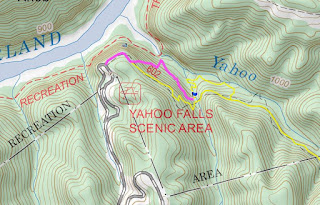
Map:
Hike Description:
From the north end of the parking area, pick up the Yahoo Falls Trail. Right after a spur on the left that leads to an overlook, go left to take the stairs down into the gorge. In a quarter-mile, reach the waterfall.
There are number of paths to view the waterfall from different angles and even go behind it.
Blog Entries:
05-Sep-2020: Arches and Falls
External Links:
National Park Service website: https://www.nps.gov/biso/index.htm


No comments:
Post a Comment