Sunday, October 26, 2014

One More Waterfall!

At this point, everybody was ready to quit. But Sandy and I are true waterfall heroes and we weren't done yet - there's always time for one more waterfall. So just the two of us, continued heading east on the highway and got off I-40 in Morganton and headed to South Mountains State Park. Fall color was peaking at these lower elevations, so it wasn’t surprising that the park was very crowded. After finding a parking spot at the Jacob Fork parking area, we hiked the High Shoals Falls Loop Trail to the waterfall.


The trail starts out following an old road and becomes more of a trail as it follows Jacob Fork upstream. As we approached the falls, the trail crossed the creek and headed up via stairs and rocks. This last section was a bit strenuous after all the climbing and elevation gain we had done for the week. After one last climb, we made it to the wooden platform at the base of the falls and got a couple of pictures of this scenic 50-foot waterfall.


We didn't linger too long as it was very crowded and we were both getting quite hungry. Back at the car, we headed into Morganton for a delicious meal of fajitas at our favorite Mexican restaurant - Las Salsas. A fitting end to a heroic week of hiking and waterfalls.

Soco and Catawba Falls

Sunday was our last day of adventure. We woke up early and broke camp for the last time and left Smokemont. We were heading east, but to avoid traffic in Cherokee, we got on the Blue Ridge Parkway to bypass tourist traffic. The early morning views along the parkway were very pretty. We got off the parkway at US-19 near Soco Gap and backtracked about a mile and a half to the pulloff for Soco Falls. Sandy and I had visited this waterfall several years ago in the snow and it was quite pretty, but we weren’t able to get down to the base, so this was our goal today with the nicer weather. We stopped briefly at the wooden overlook, but the views here are partially obscured by foliage and we could only see the larger of the two falls on Soco Creek.


A scramble path leads down to the base and there was rope tied to trees for assistance. At the base, we could see both of the beautiful waterfalls after a steep climb down.


After a couple minutes, we headed back up and continued driving east. From I-40 near Old Fort, we took exit 73 and made a sharp right onto Catawba Falls Road, following it to the end. The bridge to the Forest Service parking area is still under construction so we had to park on the side of the road here. And we weren’t the only ones visiting Catawba Falls today - there were more than a dozen other cars here. We got our stuff together and started hiking across the bridge and the parking lot that will hopefully soon be open. Almost immediately, we had to cross Catawba River. A few in the group were concerned about getting wet on this crossing so Shung stood in the middle of the river and moved some rocks around to make the crossing easier.


We continued up the trail as it followed Catawba River upstream, with another crossing over Clover Patch Branch just before a small waterfall at the ruins of an old dam and power station. Then there was another crossing over Chestnut Branch before reaching Catawba Falls.


Even before the falls, there were some very pretty cascades and small falls on the river. Catawba Falls is a big cascading waterfall, probably over 100 feet tall.


It’s not possible to see the entire thing and the fall foliage, while beautiful in color, made seeing the falls more difficult. After a couple of pictures, we then climbed the very steep trail alongside the falls that eventually reaches Upper Catawba Falls. Personally, I think this is the more beautiful of the two, though both are quite impressive.


Also, the difficult climb up to reach it reduces the number of other people and we had the falls to ourselves. We played around at the base of the falls, getting pictures and goofing off, then started making our way back to the cars.

Saturday, October 25, 2014

Mingo and Enloe Creek Falls

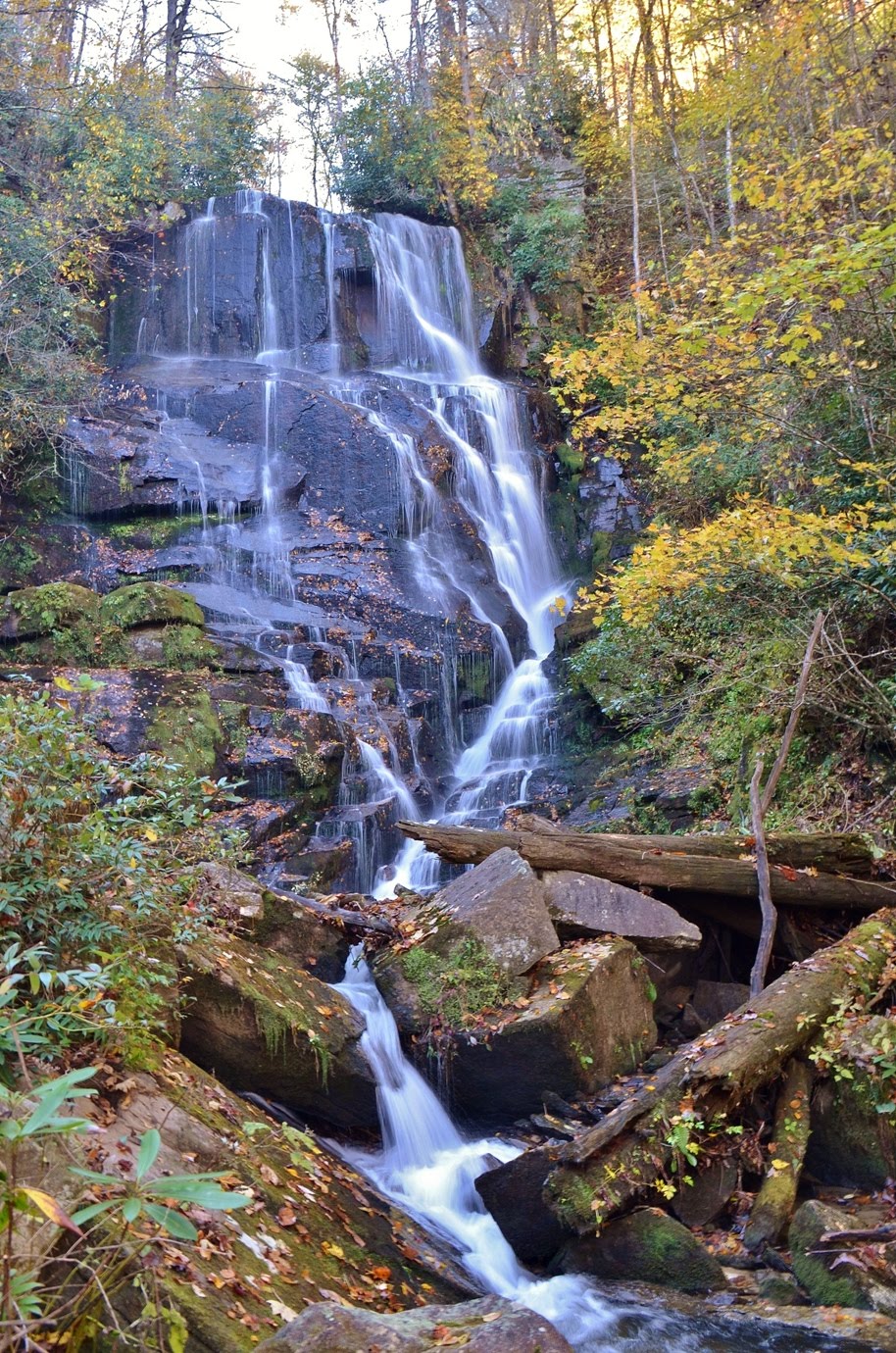
Saturday morning, we woke up fairly early. This was the one time this week that we didn’t have to break camp first thing in the morning as we were staying here for two nights. From camp, we headed towards Cherokee on US-441 and turned onto Big Cove Road right past Oconaluftee Visitor Center. In about 5 miles, we turned onto Mingo Falls Bridge Road and parked at the trailhead for the waterfall. It’s only a quarter-mile to the falls, but requires climbing more than 100 stairs. It was quite cold this morning so a quick climb helped warm us up. The trail ends at an overlook across Mingo Creek with a view of the falls. Mingo Falls is probably over 100 feet.


It didn't have a high water flow this morning, but is quite beautiful nonetheless. The main flow of water was cascading down the left side of the rock face, but there were a number of thin streams of water on the right side with a delicate, stringy look. It was really beautiful. We climbed out on the rocks to get some pictures then headed back.


We continued up Big Cove Road back into Great Smoky Mountains National Park and parked at the trailhead for Hyatt Ridge Trail. Our goal was Enloe Creek Falls. We tried unsuccessfully to get this waterfall two years ago. There’s no trail to the falls and it’s not shown on any maps. But this time, I had a GPS waypoint and we were determined to get it. We started off by hiking up Hyatt Ridge Trail. It was still cold when we started our hike and I was wearing a sweatshirt to stay warm.


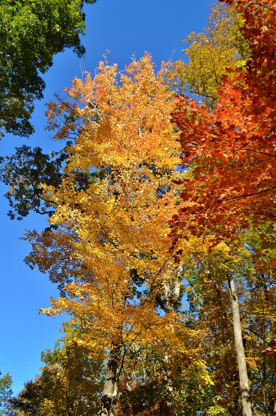
Hyatt Ridge Trail is quite steep and it wasn’t long before I paused to delayer. The trail leads for just under two miles to the intersection with Enloe Creek Trail and it’s all uphill. The foliage along the trail was showing great colors and we took several much-appreciated breaks along the hike to rest and enjoy the pretty leaves. At the top, we turned left to get on Enloe Creek Trail and started hiking down, which made for a much quicker hike, eventually reaching Raven Fork at the point where Enloe Creek flows into it.


Raven Fork Falls, an 8-foot waterfall, is located just downstream of the bridge. Although it's not a big waterfall, the bridge in the background makes for a nice picture.


We crossed the footbridge over Raven Fork and started following Enloe Creek upstream. We were only about a quarter-mile from Enloe Creek Falls and I carefully watched the GPS as we got closer and closer. For a short ways, it would have been difficult to get off the trail due to dense rhododendron, but then there was an opening and we got off trail and started bushwhacking towards the creek. Soon, we could see the waterfall through the trees and I knew we would be successful this time. As we approached the waterfall, we had to go down a bit and cross the creek on a huge log and then climb some rocks up to the base for a good view. A few people who didn’t feel comfortable crossing the log bushwhacked along the side and made it to the top of the falls.


We got some good pictures of the waterfall and played around a bit on the rocks, then started making our way back. We stopped at the campsite by the bridge over Raven Fork to eat lunch and I climbed down on the rocks to get some pictures.


Besides Raven Fork Falls, there are some nice cascades along the creek here.


After lunch, we started hiking back. The climb back up Enloe Creek Trail was strenuous, but the pretty fall colors provided an opportunity for frequent breaks. Once back on Hyatt Ridge Trail, it was all downhill back to the car. It was still early in the afternoon as finding Enloe Creek Falls took less time than expected. So on the way back to camp, we stopped at Oconaluftee Visitor Center.


We browsed the gift store for a few minutes then took a stroll around the Mountain Farm Museum and got some pictures of the old buildings and farming equipment.


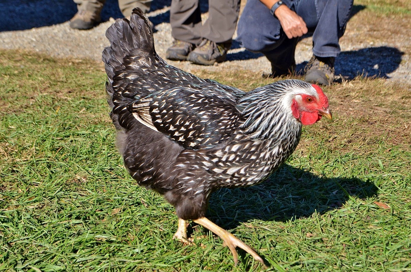
The buildings here were originally constructed throughout what is now the park and were taken apart and re-assembled at this site so visitors can get a feel for early life in Appalachia. Across the big open field, we could see a couple of bull elk grazing but they were too far away to get a good picture. I also saw a couple of chickens running around and stopped to get some pictures.


Suddenly, I heard through a megaphone a ranger scream “Step away from the wild animal!” Surely, she couldn’t have been scolding me about getting too close to a chicken. They’re certainly not wild! No, it was some idiot getting too close to the elk. And he was completely ignoring the ranger. She repeated her command to back away from the elk, but he didn’t listen. Finally, another ranger in a vehicle with sirens and flashing lights sped across the field, ultimately scaring the elk back into the woods. I couldn’t see how it was resolved, but I certainly hope the guy got a citation for that. After that, we headed back to camp and made an early dinner, then headed to Clingmans Dome with a plan to watch the sunset from the highest point in the park. We drove up Newfound Gap Road and turned onto Clingmans Dome Road. As we approached the peak, it got cloudier and cloudier and by the time we parked, we could barely see five feet in front of us. So much for a nice sunset. But we were already here, so we made the short hike up to the summit and climbed to the top of the tower.


There were no panoramic views from up here, but it had a spooky feel being right in the dense clouds. We stopped at the top of the tower for a few minutes, but there was no point in waiting until sunset since we certainly wouldn’t see it, and so headed back to the car. Driving back to camp, we got out of the clouds and could view the sun’s last moments in the sky as we drove back down US-441. We made a nice big campfire to stay warm and had drinks with our friends for the evening and then went to bed.

Friday, October 24, 2014

Deep Creek Waterfalls

We headed to the Deep Creek area of Great Smoky Mountains National Park to hike the short three-waterfall loop. We started off along the Deep Creek Trail heading upstream along its namesake creek. In just a couple of minutes, we passed Tom Branch Falls, which flows into the creek from the other side. The waterfall is pretty high, probably around 60 feet, but the water level was a little low and much of it was obscured by foliage.


Nonetheless, it was a pretty waterfall that doesn’t require much effort to see it at all. Continuing on the trail for about a half-mile, we came to a split and turned right on Indian Creek Trail. Almost immediately, there was a spur trail to the left that led down to a view of Indian Creek Falls. It’s a 20-foot cascading waterfall that was split into two streams.


It's not a big waterfall, but quite scenic. After a couple of pictures, we went back to Deep Creek Trail and then turned left on Deep Creek Horse Trail. This trail was a bit steep heading up initially and then back down. I guess horses don't mind the elevation gain too much. When we were almost back to the parking lot, we turned onto Juney Whank Falls Trail and made a quick stop at the waterfall. This is another small but scenic waterfall.


Split into multiple sections, we got some pictures from the footbridge that crosses it in the middle. It was getting late in the day, so we didn’t spend a lot of time here. A couple quick pictures and then we headed back to the car and started making our way towards Smokemont. We stopped for fast food in Bryson City and then continued past Cherokee to Smokemont Campground. After finding the group sites, we set up our tent as darkness began to fall on the mountains. Once we were set up, we made some drinks and socialized around the campfire before heading to bed.

Middle Falls on Snowbird Creek

Friday morning, we broke camp, and headed towards the Snowbird Backcountry Area in the Cheoah Ranger District of Nantahala National Forest. From US-129, we turned onto NC-143 passing Santeetlah Lake and turning on Snowbird Road and then Big Snowbird Road. Eventually, this road becomes gravel Forest Service Road 75 and ends at the trailhead. Along the way, we passed an extremely large hunting party - around 15 or so trucks and probably 30 to 50 hunters. They had to move a couple of their trucks so we could get by and while passing, I noticed that the person moving the truck looked to be about 8 years old. Shouldn't he be in school? I guess hunting takes priority in this area. He wasn’t old enough to drive, but he sure did know how to maneuver that truck on a narrow gravel road. Shortly after passing the hunters, we arrived at the trailhead and started hiking along Big Snowbird Trail (#64). The trail follows Snowbird Creek upstream for a ways and was very scenic. In about 2.5 miles from the trailhead, we came across an old car just off the trail that was peppered with bullet holes.


I don’t know if this car was used in illegal activities or if it got shot up for target practice after it had broken down back here. But either way, we had some fun getting pictures and pretending to be gangsters in the bullet-ridden car. Right past here, we had to cross the creek where Sassafras Creek flows into Snowbird Creek and turned right once across to stay on Big Snowbird Trail, where left becomes Sassafras Trail. We continued following the trail for about another mile and stopped for a brief detour down to the lower section of Big Falls on Snowbird Creek.


Despite the name, Big Falls is not particularly big. The upper part is a series of small cascades and the lower section is a larger cascade, maybe 15 feet. From the lower section, we couldn’t get to the base for a decent shot, so we didn’t spend a lot of time here.


After a few minutes, we made the very steep climb back up to the main trail and continued on to the next creek crossing over Snowbird Creek. There is a nice footbridge here to make the crossing easier.


Across the bridge, Big Snowbird and Middle Falls Trail (#64A) split. Both trails lead to Middle Falls, but Big Snowbird Trail has a number of creek crossings. So we opted to take the dry route and follow Middle Falls Trail. Initially, the trail is a very steep ascent up to a ridgeline above the creek, then levels off. It was about another mile to Middle Falls on Snowbird Creek.


Although its not a tall waterfall, maybe 15 to 20 feet high, it’s as wide as the creek and quite powerful. The setting of the falls is absolutely beautiful and the waterfall is extremely photogenic.


The long hike (about five miles one way) and remote location keep most visitors away so we had the falls to ourselves. We sat along the big rocks at the base of the waterfall and ate lunch here and got some pictures of this beautiful waterfall.


When we were finished, we made the hike back to the cars.


Once back at the cars, we split up. Justine and the others were heading straight back to Smokemont Campground to meet the rest of our group who were coming out for the weekend. Sandy and I wanted to get some more waterfalls along the way. Leaving the Snowbird area, we made a quick stop at the boat ramp next to the Cheoah Ranger Station for some nice views of fall foliage on Lake Santeetlah. Then we returned to Robbinsville and started heading back east, stopping near Bryson City.

Thursday, October 23, 2014

Franklin Waterfalls

Leaving from Rosman, we got back on US-64 West and continued past Cashiers, Highlands, Cullasaja Gorge, and finally Franklin. About 12 miles past Franklin, we turned onto Wallace Gap Road and then onto Forest Service Road 67 towards Standing Indian Campground. We drove this forest road for several miles past the campground to the trailhead for Big Laurel Falls Trail (#29) and Timber Ridge Trail. After a fairly long drive, it was nice to get out of the cars and go for a little hike to stretch our legs. Following the trails, we crossed the bridge and turned right to stay on Big Laurel Falls Trail for about a half-mile to the waterfall.


Big Laurel Falls is not a large waterfall, maybe 20 feet, but very scenic. It has an upper drop followed by some nice cascades. It’s also pretty remote, requiring a fairly long drive on the gravel forest road, so we had the falls all to ourselves.


But we couldn’t linger long as we still had more driving and little more hiking to complete before the sun went down. We tried to find the nearby Mooney Falls, but didn’t have any luck finding the trailhead, so we continued on. Back at US-64, we went east for a short ways and got on Wayah Road. In about 6 miles, we turned left on Forest Service Road 388 (Boardtree Road). This road isn’t listed on the GPS and it thought we were driving off road. But there was in fact a road here and we followed it about 2 miles to the trailhead for Rufus Morgan Trail (#27). Another short trail, it took us about fifteen minutes to reach the nice 60-foot waterfall.


It is named for Rufus Morgan, a Episcopal priest and conservationist from the area who had a deep love for the Southern Appalachian mountains. He hiked up to Mount LeConte more than 100 times, up until his 90s and maintained a significant portion of the Appalachian Trail.


We got some pictures at the waterfall, then finished the loop out back to the car, for a total of about a mile. We then backtracked to Wayah Road and continued on this road, past Nantahala Lake and Nantahala River Gorge. We turned left on US-19 and then took US-129 into Robbinsville. Our home for the night was Simple Life Campground. After setting up our tents, we headed into town for dinner at El Pacifico Mexican Restaurant. The food was decent, but it just seems weird eating Mexican food without beer. Robbinsville is in Graham County, which is still dry. After dinner, we made a small campfire and took showers at the campground, our last opportunity to bathe on this trip, and then went to bed early.

Log Hollow and Eastatoe Falls

Thursday morning, we woke up early, before sunrise, and broke camp. From Davidson River Campground, we went north on US-276 a ways, turning left on Forest Service Road 475B. We drove about 1.5 miles and parked at the gated FSR 5043 just as the sun was rising. After our failure to get High Falls yesterday, I was determined to get all of our target waterfalls today. We started off hiking down the Forest Road to the first bridge and turned right to follow a faint path upstream along the small tributary. It was less than a quarter-mile to the Waterfall on Northern Tributary of Log Hollow Branch.


The waterfall is about 50 feet, but the watershed is small so the waterfall wasn’t too impressive. I would like to visit again after a good rain as I believe that this one would be a lot better with higher water flow. After a couple of pictures, we backtracked to the forest road and continued hiking. Shortly, we reached another bridge and could see the next waterfall from the road - Waterfall on Log Hollow Branch.


This waterfall is smaller than the others - maybe 30 feet - but it had the best water flow. A leaning tree was right in front of the waterfall making photos challenging, but I found an angle to shoot with the tree framing the falls. Then we continued hiking up the forest road another half-mile to the last waterfall on this hike.


Waterfall on Southern Tributary of Log Hollow Branch is the highest of the waterfalls, but had the puniest water flow. It’s right along the forest road, but was barely noticeable in low flow.


We got some pictures and then hiked back to the cars. I imagine that the best time to see all these waterfalls is right after a good rain. Back at the car, we left the forest and got on US-64 West. In Rosman, we turned on US-178 and stopped by Eastatoe Falls. This beautiful waterfall is literally in someone’s backyard, but the people who live here are kind enough to allow public access. Along their driveway, they have signs directing to waterfall parking and a warning of a very friendly dog. As soon as we got out of the cars, we were greeted by this adorable dog. Very friendly, indeed, though he didn’t have a name tag so we weren't able to find out his name. We could see the waterfall from the parking area, but we let the dog lead us to the waterfall. It seems that he's used to showing visitors the way and seemed to be really enjoying the company.


Eastatoe Falls is a really beautiful waterfall, maybe 60 to 70 feet high in a most beautiful setting. We stayed here for a while taking pictures and playing around the waterfall. The friendly dog seemed to really be enjoying the attention and even posed for some pictures with us.


And he seemed quite disappointed when we were leaving. The landowners here should be commended for allowing the public to access this beautiful waterfall on their private property.

Wednesday, October 22, 2014

Back to Brevard

Wednesday morning, we woke up early, had breakfast at the hotel and checked out. We would be meeting Justine, Bill, and Grace in Brevard, but since they were driving from Raleigh, we had a little time to kill. So we headed to Gorges State Park for a quick hike along Horsepasture River. We had been to the waterfalls along here many times, but never during fall foliage, so this would be a great spot to wait for our friends to join us. We hiked the moderate Rainbow Falls Trail (#499) into Pisgah National Forest for about 1.5 miles to the beautiful waterfall.


Surprisingly, there was no one else here (and yet we had seen someone at Dismal Falls the day before!). The fall foliage surrounding the waterfall was gorgeous, the best fall color we had seen yet. And there was even a nice rainbow, adding more color to the scene!


Amazingly beautiful...this was definitely worth the detour. We spent some time here, enjoying the beautiful falls and rainbow and made a quick run up to Turtleback Falls before heading back to the car.


The foliage along this stretch of Horsepasture River was absolutely beautiful.


But we couldn’t spend too long as we had to meet our friends and had more waterfalls to get. So we hiked back to the car, passing several groups of people heading towards the waterfalls.


I guess we weren’t the only ones who wanted to visit this falls today, just the earliest to arrive. Back at the car, we left Gorges and headed back to Brevard. We stopped at Subway again to get our lunches for the next couple of days and then met our friends at Davidson River Campground, where we would be camping tonight. After setting up our tents, we headed north on US-276 and turned onto Forest Service Road 477 (Avery Creek Road). In about 2.5 miles, we came to a pulloff under some power lines and started hiking on Buckhorn Gap Trail (#103). Some incredibly mature person defaced the first letter on the trail sign to form a profanity. The orange-blazed Buckhorn Gap Trail leads about 2 miles to the waterfall. It’s also an equestrian trail and there were several spots where the trail fords a creek, but log bridges were available to cross without wading. After about two miles, we took the Twin Falls Trail (#604) to the waterfall. Although there are two falls, it’s not possible to see both at the same time.


We first went to the one on the left (on Henry Branch) and had lunch here. This is definitely the more impressive of the two.


We climbed around at the base of the falls and got some pictures, before heading to the other one (on an unnamed tributary of Henry Branch). The water level was not that high and this one was mostly obscured by foliage and downfall.


We got a couple pictures and then started making our way back to the cars. Once back, we drove back to US-276 and continued north. Past the Cradle of Forestry, we turned right on Forest Service Road 1206 and then another right on FSR 476 and followed this to the end. We parked here and set off on our last hike of the day to see High Falls on South Fork Mills River. We started off on South Mills River Trail (#133) for about a mile to concrete bridge.


At this point, we got off the main trail and followed another unlisted trail that crossed Billy Branch and continued following the river. In about another mile, the trail appeared to end at the river. According to our directions, we needed to cross the river. The water level was not too high, though it was very cold, so we crossed here, expecting to pick up the trail on the other side. After wading through the frigid knee-deep water, we got to the other side, but could find nothing that looked like a trail. We bushwhacked upstream for a ways, but the going was extremely slow and it was getting late and the sun would be setting soon.


Finally, we gave up and turned around making it back to the cars right at sunset. Carefully reviewing the maps and directions, we realized that we had crossed the river at the wrong place. We needed to continue up another quarter-mile to the correct river crossing. I guess we’ll have to come back for this one. Before heading back to camp, we drove into Brevard for dinner at Twin Dragons China Buffet and then returned to Davidson River Campground. It was quite cold this night, but we didn’t even bother with a campfire.