Saturday, September 5, 2015

Walhalla Area Waterfalls

Saturday morning, we woke up early, had breakfast and departed camp. We headed north for about a mile to Burrell’s Ford Road (FSR-708). In about 2.5 miles, we pulled over at a pull-off and started our first of many hikes for the day. We made the short hike to Spoonauger Falls.


Unfortunately, this one is pretty pitiful in the low water, despite the rains the night before. After a couple of quick pictures, we headed back to the car and drove just a short ways back up FSR-708. There’s a large parking area for Burrells Ford campground where we parked. We hiked down the gravel road to the campground and then took the trail towards King Creek Falls. Initially, the trail follows the Foothills Trail to a bridge over King Creek. Across the bridge, the trails split. We went left to follow the trail upstream to King Creek Falls.


It’s a beautiful 75-foot waterfall and still looked good even in the low water. We crossed the logs at the base and got some pictures from the sandy beach.


There were a lot of nice wildflowers blooming around the base of the waterfall as well as a cairn in the shallow water.


We got some pictures here and then started heading back. Back at the car, we got on SC-107 south and past the campground, turned left on Winding Stairs Road, a steep and winding gravel road. At the end, we turned right on Jumping Branch Road and then right on FSR-715A. This turn can be tricky to find as it’s not on most maps or GPS. In about three-quarters of a mile, we pulled into a parking area just before the bridge over Tamassee Creek and got ready for our next hike. Lee Falls is a really beautiful waterfall, but a bit tough to find as there’s no trail. Once we were ready, we started hiking through the field past the gate. The last time I was here, it was raining, but today we had rather nice weather. So it was very pleasant hiking through the fields where wildflowers were in full bloom and a large number of butterflies were fluttering about.


We also saw a number of honey bees collecting nectar from the flowers.


We also saw some species of Physalis, which produces the most interesting "lanterns" to protect their fruit as it develops.


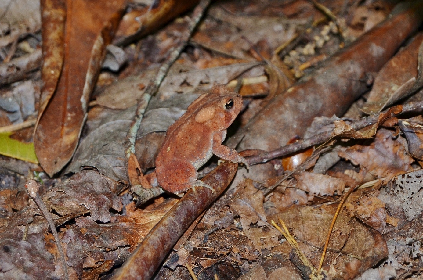
Across the first field, we had to rock hop across the creek and came to the second field. This one has two sections and after the second section, we crossed another creek and came to the third field. The last time I was here, the water level was way up and we had to wade across, but it was low enough today that we could rock hop. After this crossing, the path headed into the woods and continued following Tamassee Creek upstream towards the waterfall. We saw a cute little orange toad right along the path through the woods.

It’s not too bad until about a mile from the trailhead. We had to cross a small tributary and then head upstream. There’s not much of a trail at this point and it’s quite steep and rocky; at one point we were in a narrow strip of rocks and dirt in the middle of the creek. There were a couple parts with a rather treacherous scramble up wet rocks, but soon we made it to the base of Lee Falls.


Again, the water level was low, but this is still a very nice waterfall. It really reminds of something you might see in a tropical rainforest.


We got some pictures here and had a snack then made our way back. From here, we made a short drive to Oconee Station Road and parked at the trailhead for Station Cove Falls. The small parking area was almost full, but we were able to get the last parking space. This is an easy waterfall to get and so quite popular. We hiked along the Palmetto Trail towards Oconee State Park, seeing some pretty coral fungi growing near a footbridge.


In about a half-mile, we reached the spur trail to Station Cove Falls. Some brilliantly orange Jack-o-Lantern mushrooms were growing around a tree near the turn.


It was a short way on the spur trail to the waterfall. This waterfall looked a little pitiful in the low water and there were a lot of people here, so we didn’t spend too long.


Surprisingly, we actually had cell signal here. Back at the car, we continued south to get on SC-28 and headed to Yellow Branch Picnic Area. After parking, we got on Yellow Branch Falls Trail. This is a really pleasant trail, about 1.5 miles to the waterfall. Yellow Branch Falls was one of my favorite waterfalls in South Carolina.


In high water levels, it is absolutely beautiful – it feels like a magical place. But even today, in lower water levels, it was still quite pretty and the setting still had a magical feel.


Sandy and I climbed around on the rocks and got pictures of the waterfall from different points. Unfortunately, we didn’t see the cute little salamanders all around the waterfall that I had seen previously.


As more people started to arrive, we made our way back.


Our last waterfall of the day was just across the street. We pulled into Stumphouse Tunnel and paid at the self-serve kiosk, then parked at Issaqueena Falls. There were a lot of people here. We didn’t bother stopping at the overlook, because the view of the falls is poor. Instead, we scrambled down to the base for a better view. It was so crowded here that we actually had to stand in line to scramble down to the base. Like a few others this weekend, the waterfall was pretty pitiful at such low water levels. I climbed over to the left side where there was the most water flow for a picture of the falls.


Then we headed back up and departed. For dinner, we headed into Walhalla and had Mexican at Puerto Nuevo and then started heading back towards camp. Driving north on SC-107, we passed Oconee State Park and saw a sign for waterfalls after that. We had over an hour until sunset, so figured we’d try to get one more in. We turned on left on Village Creek Road and then right on Nicholson Ford Road (FSR-775) and drove about 2 miles to a parking area on the right. We parked here and took the short connector trail to the Foothills Trail then started hiking towards Chattooga River. In about a half-mile or so, we came to another parking area at the end of FSR-775 – apparently we should have driven a little further and parked here. We hiked for another half-mile or so and turned at the sign for Licklog Falls. It was just a small 10-foot cascade that looked like it needed some more water. I did some research later on and realized this was in fact Pigpen Falls, not Licklog Falls.


Licklog Falls was just another quarter-mile down the trail. But we were running very short on daylight, so we turned back. At the parking area, we hiked the forest road back to our car as this was quicker than taking the Foothills Trail. We then headed back to camp, took showers, and enjoyed a campfire with our friends who had been in Southern Nantahala Wilderness for the day.

Friday, September 4, 2015

Westminster Area Waterfalls

For the Labor Day long weekend, Sandy and I headed to South Carolina to get some waterfalls so she could finish up the WC100 challenge. We left Friday at 4 AM to get an early start, crossing into South Carolina right around sunrise. We continued on I-85 to Greenville, then headed to Westminster on US-123. In Westminster, we got on US-76 and then turned on Cobb Bridge Road. We then got on the gravel FSR 748 and drove about 2 miles to FSR 748C. Sandy was feeling brave and we drove down this extremely narrow gravel road with many mounds. It was an interesting drive, but thankfully quite short. We parked at the end and then started our first hike of the weekend to Riley Moore Falls. It’s about 1.5 miles round trip and moderate to the falls.


At the end of the trail, we scrambled down to the sandy beach along the river for some pictures of the waterfall. The last time I was here, the water level was much higher and so this and all the waterfalls we would see were much more powerful then.


For Riley Moore Falls, however, I thought the waterfall actually looked better in low water conditions. Although the waterfall is the width of the entire river, it’s only about 12 feet high. In high water conditions, it looks more like a big rapid, but today it looked more like a waterfall. We got some pictures from the beach then climbed up to get some pictures from the side, then started hiking back.


Although the weather was dry, we saw a lot of colorful mushrooms and other fungi along our hikes this weekend.


Back at the car, we made the white-knuckle drive back up and then got back on US-76 towards Long Creek. We got on Turkey Ridge Road (FSR 755) and drove about 3 miles to the turnaround at the end of the road. From here, we began hiking down FSR 755I for about a half-mile to the end of this road. Along the way, we some some interesting flower that had opened up to reveal bright red berries.


Near the end of the gravel road, there were some downed trees and we inadvertently got off the trail and had to bushwhack a short ways. Soon, we found the trail again and continued hiking along a ridgeline above Chattooga River. In about 1.5 miles from the start, a bunch of branches and sticks blocking the trail indicated the end so we turned left to head down to river level, right where Long Creek flows into Chattooga River. Across the creek, some whitewater rafters had stopped for a break at this waterfall.


We ate lunch here and then I took off my boots and waded across the creek and headed up to the base of the waterfall. It was hot enough that the cold water felt very good. The water level was low, so I was able to climb up the rocks near the base of the waterfall.


As we were getting ready to head back, I saw a beautiful tiger swallowtail butterfly on some of the flowers blooming here.


After a couple pictures, we made our way back to the car. We then drove back on FSR-755 for less than a mile to the trailhead for Opossum Creek Falls. The trail heads through a forested area towards Chattooga River.


About half way down the trail, I heard something moving in the brushes. As I got closer, I startled it and it started to run. It was big, so I thought it was a deer, but I got a quick glance and it was big and black with a brown muzzle – a black bear. He quickly made his way into some dense rhododendron, so no way to take a picture. We decided it would be best to talk loudly as we hiked to ensure we didn’t startle another bear.


Once at the river, we turned left to head upstream along Opossum Creek to the waterfall. It’s a pretty waterfall, but the water level was low and there was a lot of downed trees and foliage blocking the view.


After some pictures, we made our way back. It was hot and humid and the entire hike back is uphill, so it was a bit of a grueling hike. No more bears along the way, though. Once back at the car, we headed back to US-76 towards Westminster and turned on Brasstown Road. In 4 miles, we turned right on FSR-751 and drove to the parking area at the end. It’s a short hike, but you sure get a lot of bang for the buck on this one. In a quarter-mile, the trail comes to Brasstown Creek at the top of the waterfall. We hiked a short ways downstream to see the upper section, about 50 feet of cascades.


Looking downstream, we could see the edge of the middle section. We continued down and came out at the base of the middle section, a 20-foot veil over a ledge and probably the most scenic section of the waterfall.


We also climbed out on some rocks to get a view of this section from further away.


It's the nicest section of the waterfall in my opinion. Then we continued down to the lowest section, a 15-foot chute. There was no way to get a good picture from the rocks, so I waded into the shallow pool to get a picture.


Then we started making the climb back up to the top of the waterfall. But we weren’t quite done yet. We continued upstream past a campsite and waded across the creek to Little Brasstown Falls, another pretty 20-foot waterfall where Little Brasstown Creek flows into Brasstown Creek.


After a couple pictures, we headed back. Driving back out, we stopped for dinner at Brasstown Creek Gathering Place. I had been here before and think they have some of the best barbeque around and wanted Sandy to try it. After dinner, we headed north to Cherry Hill Recreation Area near Mountain Rest where Justine and the others were camping.


We set up our tent and took a quick shower and then went to bed after a very long day. Overnight, there was a heavy rain, but unfortunately, not enough to really help the waterfalls.

Sunday, August 23, 2015

DuPont State Forest Waterfalls

Sunday morning, I woke up, had breakfast, and checked out of the hotel. It was a long drive home and I wanted to get in a good hike before I left. So I headed to DuPont State Forest, just east of Brevard, and parked at the Hooker Falls parking area. After getting my stuff together, I started out on the short Hooker Falls Road to its namesake waterfall. I was here early enough that I beat the crowds and had favorable lighting to capture the falls.


One guy was swimming in the pool beneath the waterfall, but no one else was here. I took advantage and walked around a bit to get pictures of the falls and then headed back.


I took the pedestrian bridge over the river and then followed Little River upstream along Triple Falls Trail. I stopped for picture at the overlook where all three sections of the waterfall are visible. Then I then climbed down to the rocks to get some pictures from here, where I could see the upper and middle sections of the falls.


It was still early and there was no one else at the waterfall. Every other time I’ve been to Triple Falls, it’s been very crowded, so it was nice to have a bit of solitude here. I continued following the trail and took High Falls Trail at the split.


After a quick stop at the overlook to see High Falls, I took Covered Bridge Trail up to the bridge over the waterfall and followed Buck Forest Road.


I followed the road for just under a mile to a bridge over Grassy Creek and then took Lake Imaging Road to Grassy Creek Falls Trail. Along the way, I saw some black-eyed susans blooming along the road.


The trail ends at the top of the waterfall and the views aren’t very good. So I bushwhacked down to the base, but it was very cluttered and I couldn’t really get a decent view here either.


It’s not that scenic of a waterfall anyway, so I gave up and headed back. Once across the covered bridge, I made a partial loop by taking Triple Falls Trail all the way back.


Along the way, I saw some great mushrooms growing right along the trail.


At the base of the lowest section Triple Falls, I headed out onto the rocks to get some pictures, though the waterfall had become crowded by this time.


Then I finished my hike back at the Hooker Falls parking area. It was still early so I drove over to the Guion Farm parking area off Sky Valley Road. From here, I hiked to Wintergreen Falls, the last waterfall in the forest that I had never visited. I hiked south through an open field and got on Tarkiln Branch Trail. I followed this for about a mile and turned left on Wintergreen Falls Trail. It was about a half-mile to where the trail ends at Grassy Creek. From here, I had to scramble over some big boulders for a view of Wintergreen Falls.


Although not big, it’s a very scenic waterfall and much less crowded than the more popular waterfalls on Little River. It's more scenic that Grassy Creek Falls in my opinion. I got some pictures here and then hiked back to the car. I started making my way home, passing through Hendersonville and getting on I-26. When US-74 split, I got off the highway in Columbus at NC-108. I turned on Houston Road and then White Oak Mountain Road. This last road, although paved, was extremely steep and windy as it switchbacked up the mountain. At a couple points, I had to come to a complete stop and put the car in first gear to get up the hills. After two miles, I parked right before Shunkawauken Falls.


This roadside waterfall is quite high; surprising, considering how high on the mountain it is. I got a couple of pictures of the waterfall and of the views over Columbus far below the mountain.


After enjoying the view, I returned to the car and drove back to the highway and made my way home.

Saturday, August 22, 2015

High and Big Falls

This past weekend, I headed to the mountains to see High Falls on West Fork Tuckaseegee River. August 22 would be the last time this year that Duke Energy would be opening the dam on Lake Glenville for a whitewater release. Sandy had to work this weekend, so I headed out solo. I drove up Friday evening and stayed at the Quality Inn in Sylva, as I wanted to get a quick start in the morning and be there before the dam opened at 10 AM. I had Subway for dinner and saved the second half for lunch the next day. Saturday morning, I checked out of the hotel and headed south on NC-107. Just before Lake Glenville, I turned right on Shoal Creek Road and parked just beyond the gated road, arriving around 830, with plenty of time to make it to the waterfall. This land is private property, but the landowner is kind enough to allow public access to view the beautiful natural resources. After getting my stuff together, I hiked down past the gate and went left at the fork. The trail loops around and then follows West Fork Tuckaseegee River upstream. In about a mile and a half, flagging tape indicated a short spur trail to the right that led to the river. Across the river, Rough Run flowed into West Fork Tuckaseegee River at Rough Run or Thurston Hatcher Falls.


The other side of the river is private property and marked as No Trespassing, so I could only go as far as shore of the river to get a picture of this waterfall. Then, I hopped back across and finished up the trail at the base of High Falls.


It was still another thirty minutes or so before the dam would open, so I took the time to walk around on the rocks at the base of the falls that would soon be completely underwater. There were a couple of cairns right at the base of the falls – they wouldn’t be lasting much longer!


As it got closer to 10, I found a nice big rock to climb up where I would be safe from the rising water and be able to get some good pictures and video. Around 1020, it actually started. I’m not sure how long it takes for the water to get from the lake to the waterfall, but when it started, there was no mistake. First, the top section of the waterfall got huge. Then the lower part started in two sections and finally, the river below the falls began to fill up.


It took a total of about five minutes before the waterfall and river got to their full flow. After getting some pictures and video from the top of the rock, I got back down to the edge of the river and then went up to where the kayakers were putting in. The mist and spray from the falls made it difficult to get pictures. I even climbed up to the middle of the falls, where the spray was overpowering.


I watched some kayakers take off down the now Class V rapids and then made the hike back to the car.


On the way, I stopped quickly at Thurston Hatcher Falls - there would be no crossing the river now. While I was here, I met Tim, who wanted to go to Big Falls on Thompson River afterwards. I never pass up an opportunity for adventure on Thompson River, so we drove over to the trailhead on Brewer Road, just off NC-281. From here, we hiked down the old gated logging road that follows Thompson River downstream. In about a mile, we passed the side trail that leads to High Falls and shortly after that, we had to ford the river. The water level was lower than the last time I was here as there were several exposed rocks sticking out above the surface. Not enough to rock hop though, so we had to wade across. We continued down the path another 2.5 miles to the turn for Big Falls. It’s not terribly obvious, but I spotted the flagging tape and cairn at the turn. From here, it’s a steep climb down to river level. It starts off moderate, but gets steeper and steeper. Ropes tied to trees help with the steepest parts near the end. Once down to the river, we had to go upstream a bit to the base of Big Falls. A downed tree made getting to the base difficult the last time I was here. It appeared that another tree had fallen and it was now near impossible to get through the mess of branches and logs. Instead, we climbed onto some rocks before the trees and were able to climb under them from river level. Now, we could see Big Falls.


This certainly was a day for massive waterfalls. I ate the rest of my Subway and then we waded across the river and climbed onto the big rock on the other side. I went up as high as I could go to view the top of the waterfall up close.


Tim was going to slide down the falls, but ended up changing his mind. The water is mighty cold. So we started making our way back up. It wasn’t too hot, but was extremely humid, which made the climb back up that more difficult. But soon we made it to the top and started hiking back. Although he had talked about it on the way in, Tim was too tired to get any of the other waterfalls along Thompson. He decided to set up his hammock, while I headed down to Waterfall #1 on Thompson River.


I had never been to this one before and for being on Thompson River, it was pretty easy. And it’s a pretty nice waterfall too! I was glad I made the quick detour here. I also saw some tiger swallowtail butterflies puddling along the river bed.


I hiked back up to the main trail and met back up with Tim, resting in his hammock. He packed it back up and we finished the hike back out. Along the way, we ran into some guys who had been looking for White Owl Falls. Unfortunately, this wasn’t the trail to take. We told them how to get to it, but they didn’t want to take the time to get that one. We talked to them along the hike out. Tim headed home and I went into Brevard to stay at the Hampton Inn for the night.

Saturday, August 1, 2015

Minnehaha Falls

Saturday morning, we finished packing and left the house around 730. We dropped Betsy, Laura, and Steve off at Glacier International Airport and then drove to Missoula. After clearing security, I got a huckleberry scone for a snack before boarding the plane. It would be my last time eating huckleberries for a while. Our first flight to Minneapolis was on time and our layover was 3 hours. I didn’t want to just hang out in the airport, so Sandy and I got a taxi and went to Minnehaha Regional Park, part of Mississippi National River & Recreation Area to get one last waterfall. The taxi dropped us off in the park about a mile from Minnehaha Falls.


We hiked quickly and got a couple of pictures of this impressive waterfall before hiking back quickly.


It’s a very nice 50-foot waterfall, especially given its proximity to a major airport. Definitely worth a detour if you have a layover in Minneapolis.


The cab driver had given us his card, so we called him and he picked us right back up and brought us back to the airport. Altogether, it took about an hour and half to get back to our gate, more than enough time for dinner and couple drinks at the airport before it was time to board the plane. A couple of people I talked to on the plane thought I was a little crazy for leaving the airport to get one more waterfall, but there was more than enough time and it made for an interesting story. We got back to RDU at about 11.