Monday, October 20, 2014

Highlands Waterfalls

Monday morning, we woke up a little later and had a nice breakfast at the hotel. After getting ready, we headed into Cashiers, turning left on NC-107 south for about four miles to the trailhead for Silver Run Falls.


We hiked the short Silver Run Falls Trail (#435) to this scenic waterfall and got some pictures from various angles.
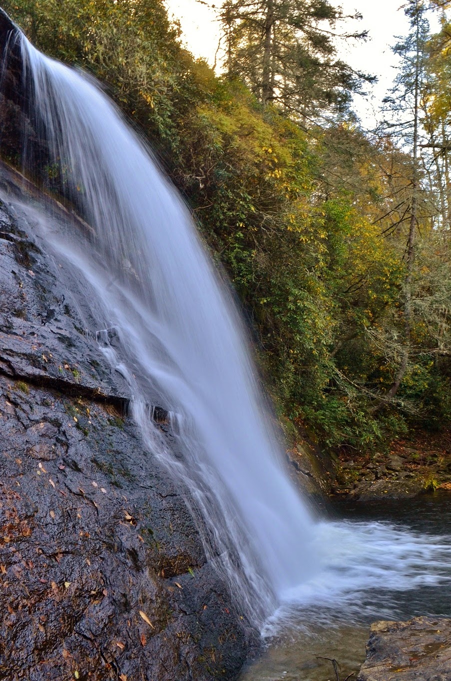

But just one waterfall is not enough! Along the cliff face next to the waterfall, a bunch of roots and rocks made a steep scramble path up to the top. We climbed up here and followed a faint path upstream through dense rhododendron a short ways to Upper Silver Run Falls, a nice 15-foot cascading waterfall.


After a few pictures, we headed back.


Climbing back down the cliff, we got a couple of curious looks from others who were at the lower waterfall. I don't think they realized that there was another waterfall further upstream and probably had no intention of following in our footsteps.


Back at the car, we continued south on NC-107, turning right on Bull Pen Road, which becomes Forest Service Road 1178. We drove about four miles to a pull off on the side of the road, near the gated FSR 4564. Directly across from the gated road, we could hear and partially see a waterfall on Scotsman Creek below. There was some flagging tape, so we started a challenging, but short bushwhack down to the creek. Although it was really short, the hike was remarkably challenging. We barely walked on actual ground, having to walk and crawl along rhododendron branches and thick brush. There was a waterfall here, but it wasn’t the one we were looking for.


This is the Upper Waterfall on Scotsman Creek - it’s not a bad waterfall, though not necessarily worth the challenging scramble down to the creek. We headed back up to the road and hiked a short ways down the gravel road to a curve to the right and found more flagging tape. This was the right trail! We hiked down another short, but challenging bushwhack to Scotsman Creek, this time to the right waterfall.


This is a really cool waterfall. The water splits into two streams and falls over a cliff face, then cascades down.


The two streams go around a small island in the middle in the middle of the creek. We sat for a little while here and I took off my boots and socks to wade in the creek below the falls. The water was very shallow and I wanted to get pictures from different angles as well as head over to the island in the creek.


When we had enough, we climbed back up to the road and made our way back to the car. In another mile or so, we came to the Bull Pen Bridge (also called the Iron Bridge by locals) over Chattooga River and decided to make a quick stop.


First, we climbed down to river level downstream of the bridge.


From here, we could look upstream at the bridge and the Potholes, a series of cascades right under the bridge.


Then we went back up and headed upstream to some rocks for a nice view of the bridge amidst the fall color.


Several families were here at the rocks and we stopped to talk with them for a few minutes. Although the Potholes isn't a real impressive waterfall, the rocky area is great spot to enjoy the natural beauty. After a few pictures, it was time to head to some more real waterfalls. We continued driving down Bull Pen Road to Highlands and got on NC-106 to Glen Falls Scenic Area. There were quite a few cars in the parking lot, but we didn’t see a lot of people on the trail. The trail is about three-quarters of a mile and moderate as it heads down the waterfall. Our first view of the falls was from the top.


We couldn’t see much of the waterfall, but the fall foliage here was absolutely gorgeous. From here, we headed down to the base of the upper section, consisting of two free falls and some nice cascades.


Then we headed down even more stairs and switchbacks to the base of the middle section. The middle section is perhaps the most impressive, a 60-foot series of cascades.


We got some pictures here and ate our lunch at the base of the middle section. While we were eating, a group of ladies came down for some pictures then headed back up before we finished. When we finished our lunch and started heading back up, I spotted an iPhone on the ground near the waterfall. The group had a five or ten minute head start on us, but I figured I could hike a lot faster than them, especially uphill, so I grabbed the phone and headed back up. Near the base of the upper section, I saw a lady heading back down, looking distressed. Sure enough, she had dropped her phone and was very grateful that I had brought it up to her and she didn’t have to go all the way back down. We finished up our hike at the car and made our way back to Highlands, then going south on NC-28. We turned onto Blue Valley Road that eventually became Forest Service Road 79. In about 4 miles, or about a half-mile past Blue Valley Campground, we pulled over near a gated road. From here, we hiked up the gated road for about a half-mile to a clearing with nice views of the pretty fall color.


Right past the clearing, we reached a creek and headed upstream a short ways to reach Picklesimer Rock House Falls.


Similar to Moore Cove Falls earlier in the week, this waterfall has a freefall over a cliff with a large cave, or “rock house”, behind it. And the cave was certainly big enough to stay under for shelter from a storm, though I don’t think I’d necessarily want to live there.


Unlike Moore Cove Falls, however, this waterfall is fairly unknown and we didn’t see anyone else here. Another benefit of low crowds - there was no garbage carelessly discarded around the falls.


After a few minutes, we headed back to the car and made our way back towards Highlands. Picklesimer Rock House Falls was our last planned waterfall, but it was still early enough in the day that we decided to get a couple more. We stopped at the Satulah Overlook along NC-28 on the way back to Highlands. Across the gorge, we could see Lower Satulah Falls. Although it’s over 100 feet high, viewing it from across the valley is not too impressive.


As far as I can tell, there's no way to get across for a better view of the falls. However, the view from the overlook, including Satulah Mountain, was quite beautiful with all the fall colors and made the stop worthwhile.


We then continued into Highlands and got on US-64 west towards Cullasaja River Gorge for a couple more easy waterfalls. First, we drove under Bridal Veil Falls and then stopped to get a couple of pictures.


Then we went another mile or so and stopped at Dry Falls.


It’s a short walk to this huge 70-foot waterfall and not surprisingly, there were a lot of people here.


The name Dry Falls comes from the fact that normally, you can walk behind the waterfall and stay dry.


The water level seemed to be up a bit and I got misted walking behind the falls. Not always so dry.


After some pictures from different angles, we headed back through Highlands to Cashiers and had dinner and drinks at Gamekeepers’ Tavern, just up the road from our hotel. Eating at the bar, I had a cheeseburger and Sandy had venison meat loaf and we both really enjoyed our meals. I also had an Autumn Russian, a cocktail made with pumpkin-spice vodka, Kahlua, cream, and a dash of nutmeg. It was yummy! After dinner, we headed back to the hotel and took a dip in the hot tub before bed. Our next day in Little Canada was going to be a challenging one!

Sunday, October 19, 2014

Thompson River Waterfalls

Sunday morning, we woke up cold and quickly broke camp to get off the mountain. The wind had died down a bit overnight, but it was cold and very cloudy. As we got back on the parkway, the visibility was poor but the clouds began to break as we headed south and there were clear blue skies by the time we reached US-276. We went south on the highway and then west once we hit Brevard on US-64. We continued to Sapphire and then took NC-281 south past Gorges State Park and parked along the side of Brewer Road. The unofficial Thompson River Trail begins from here. We walked along the gated logging road for about a mile, passing the side trail to High Falls. The trail then switchbacked down and led to a ford across Thompson River. When I had been here before, we were able to rock-hop across the river during near drought conditions, but the water level was too high today so we had to wade through the chilly water. Once across, we continued following the old logging road as it ran parallel to Thompson River. Although we could rarely see the river from the trail, we could hear it often as the water roared over falls and cascades.


In about 2 miles from the river crossing, we came to the side trail that leads down to Big Falls. Despite using GPS, we initially passed the side path and had to turn around. The logging road continues past here, I believe ending at the Foothills Trail, though I haven’t followed it that far. We initially passed the turn, despite using GPS, but found it easily after turning around when I realized we must have passed it. There was a cairn and several pieces of marking tape so I don’t know why we didn’t spot it the first time. The path down to Big Falls starts out gradual and deceivingly easy. Then it gets a little steeper and steeper and steeper. Fortunately, someone has tied ropes to the trees at some of the steepest parts to assist in the descent. Finally, the trail comes down to the river below the falls and goes upstream to the base. Another piece of rope helped us get down a huge boulder and then we came to a fallen tree. Peering through the branches and logs, Sandy spotted another piece of marking tape, so we climbed through the mess of branches and came out at the base of the waterfall.


The water level was high enough that we couldn’t cross to the big rocks on the other side without getting wet. It was over my knees and fast moving, so Sandy decided to stay dry while I crossed over to get some pictures.


This is a beautiful waterfall - one of my favorites in North Carolina. And it was really flowing with higher than average water levels. Unfortunately, it was hard to get a good picture as the midday sun was shining right on it and the water level was high enough to create quite a bit of spray and I had to keep cleaning off the lens. The name Big Falls really seems appropriate when walking up the side on the big exposed rocks.


We had lunch down here and enjoyed the beautiful waterfall, then made the very strenuous climb back up. The last time I had been here was in the summer when it was really hot. The climb seemed a lot easier in the cool autumn weather and soon we were back at the top. We started making our way back along the logging road and in about a half-mile or so, we took the side trail down to Waterfall #2 on Thompson River. It was well-marked with tape and easy to follow, though rather steep. This waterfall is a pretty cascading falls, about 35 feet high.


I climbed out on the rocks to get some pictures and then we headed back to the main trail. A little ways further on the trail we saw an enormous bright green caterpillar on the trail; I believe that it was a Polyphemus caterpillar.


After crossing Thompson River again, we took the side trail to High Falls. It’s about a half-mile and easy until the last decent down to the river.


We had to wade again to get across the river and into a good spot to view the waterfall. The water was cold, but High Falls was quite beautiful.


We got a couple pictures here and then headed back to the car. By the time we got back to the car, it was getting late, but we still had an hour or so of daylight - time enough for some more waterfalls! We drove just a short ways up NC-281 and parked on the side of the road, just before Whitewater Church Road. From here, we hiked the short D.E.W. Falls Trail (#281) about a quarter-mile to the waterfall.


This is a smaller waterfall but quite scenic, named for Dorothy Ehrlich Walker, a young lady who tragically died in a car accident. Then we headed back across the street and scrambled down to John’s Jump, a nice 25-foot waterfall on Mill Creek a short ways downstream of D.E.W. Falls.


Since these were such short hikes, we decided to get one more waterfall for the day. We started heading back on NC-281 and parked along a gated forest road before Brewer Road, then walked down the highway to a faint trail just past the guard rail. It was a short hike down to Thompson River for White Owl Falls. It’s not a big waterfall, but quite beautiful and photogenic given the easy hike to reach it.


After a few pictures, we headed back up to the car as the sun was beginning to set. We drove into Cashiers for a quick dinner and then checked into our hotel - Hampton Inn. After getting settled into our room, we hit the hot tub before bed. It felt amazing after such a strenuous day.

Saturday, October 18, 2014

Pisgah Forest Waterfalls

For Fall Foliage this year, Sandy and I took a whole week to head out to western North Carolina and go on an epic waterfall hunting adventure. We left very early in the morning on Saturday and made our way west, arriving in Pisgah Forest around 10. We made a quick stop at Subway to get our lunches for the next two days and then headed into Pisgah National Forest. From US-276, we turned onto Forest Service Road 475 and drove past the Pisgah Center for Wildlife Education and parked at the trailhead for Daniel Ridge Loop Trail (#105). It was a Saturday during peak fall foliage, so not surprisingly, the forest was very crowded. The small parking lot at the trailhead was full, so we parked along the forest road just past the trailhead. Once we got all our stuff ready, we started off for our first waterfall of the week - Toms Spring Falls. We hiked up the gated road and across the bridge over Davidson River and turned right to continue on the road. In about a half-mile, right past where Daniel Ridge Loop Trail splits from the road, we got to Toms Spring Falls, which is also called Daniel Ridge Falls or Jackson Falls.


The waterfall is on Toms Spring Branch, which has a fairly small watershed. Despite heavy rains the week before, this one still had pretty low flow, but its still a nice waterfall given the easy hike. We first hiked up a side trail to view the falls up close from about the middle point, then headed back to the road to see it from the front.


One down, more than forty to go! We didn’t spend too much time as we had many more waterfalls to get so started heading back after a couple pictures. Back at the car, we drove back a short ways on FSR 475 and parked outside the gate leading to Cove Creek Group Campground. There was a bicycle event so this area was even more crowded than expected. We parked along the forest road and hiked up the gated road towards the campground. Along the way, we stopped to see some nice cascades along Cove Creek.


At the campground, we tried to get on Caney Bottom Trail, but missed a double blaze and continued on an old road. After a few minutes, we realized we were not going the right way and saw another group of hikers. We asked them and they too were heading to the waterfall but had missed the turn. I felt a little better that we weren’t the only ones who missed the turn.


We headed back to the campground and found the double blaze and got on the blue-blazed Caney Bottom Trail (#361). In about ten minutes, the trail split and we took the yellow-blazed Cove Creek Trail (#340), which leads to the falls. In about ten minutes or so, there was a side trail that leads steeply down to the waterfall. Despite the crowds near the campground and trailhead, we were the only ones at the waterfall, so we took the opportunity to enjoy our lunch near the base.


To get some good pictures of the falls, I waded into the creek at the base. The water was very cold! But at least it was only ankle deep and wading allowed me to get some nice pictures of the falls. As we finished our lunch and got some pictures, more people started arriving at the waterfall, including those who we had seen when we made a wrong turn. With the crowds arriving, we departed and headed back to the car. We drove back to US-276 and headed north. I was planning for a quick stop at Looking Glass Falls, but expected a crowd given its popularity. This is one of the most popular and easily accessible waterfalls in the forest. Although it’s roadside, we had to park almost a quarter-mile down the road to find a spot.


The waterfall was very crowded so I climbed out onto a big log past the viewing deck to get some nice pictures without people in the way.


Then we continued up US-276 a short ways to the parking area for Moore Cove.


Just before the bridge on US-276, we crossed a footbridge to get on Moore Cove Trail (#318) and followed this pleasant trail for about three-quarters of a mile to Moore Cove Falls.


The fall color in this area was beautiful and it was a lovely walk to the waterfall. Moore Cove Falls is a 50-foot waterfall over a cliff with a grotto behind the falls.


This waterfall is probably second in popularity to Looking Glass, so it was kind of crowded.


We did manage to walk around the get pictures of the falls from different angles, including from behind it in the grotto.


We also saw a small rainbow near the base.


As more people arrived, however, we decided it was time and headed on. Back at the car, we continued up US-276 to the Blue Ridge Parkway and headed south to mile post 417 and parked at the Looking Glass Rock Overlook. From here, we had a great view of Looking Glass Rock to the southeast, but this was not our primary goal.


We crossed the parkway and took a short spur trail to connect with the Mountains-to-Sea Trail.


Along the way, we passed the dragon tree.


Past the tree, we hiked down some rocky steps and soon came to a footbridge over Yellowstone Prong at Skinny Dip Falls.


This waterfall used to be pretty unknown to anyone except locals, whose activities at the falls gave its name. Nowadays, it’s very popular, right along the MST near Graveyard Fields, and it would be hard to get away with skinny dipping here. It was way too cold for swimming anyway, with or without clothes.


At the top, we got some pictures of the upper portions of the waterfall, then went down the stairs and climbed out on the rocks for a few more pictures, though only the middle section was visible.


We also met a nice young lady here who was backpacking with her dog along the MST. I took some pictures for her and helped her figure out where she was going, and then we made our way back to the car. It was only another mile on the Blue Ridge Parkway to Graveyard Fields, our last stop for the day. The parking lot had been improved over the summer, but it was completely full and we had to park a little ways up along the parkway. We hiked to the main parking area and got on the Graveyard Fields Loop Trail (#358) and took the stairs down to Yellowstone Prong. We turned right on the MST Access Trail (#358B) and headed down to Second Falls.


There was quite a crowd at this waterfall and the late afternoon sun made pictures very difficult. After climbing out on the rocks, we headed back up the stairs to the loop trail and continued counterclockwise to the Upper Falls Trail (#358A) and hiked to our last waterfall of the day.


The hike through Graveyard Fields is beautiful though many of the trees at the higher elevations had already lost their leaves.


We got some pictures of the cascades at the base of Upper Falls and then headed up to the main waterfall.


Unfortunately, due to a camera malfunction, I didn't get any pictures of Upper Falls. I guess, I'll have to come back again some time soon. Then we started making our way back, finishing up the loop trail back at the parking area ready to head to our camping spot for the night.


Before we drove too far off, however, we stopped along the parkway and got some pictures of Second Falls from a distance with the setting sun behind the mountains - a truly beautiful scene.


We also made a quick stop at East Fork Overlook for more nice fall foliage views from the parkway in the late afternoon sun.


Finally, we headed north on the parkway to Mount Pisgah Campground, our home for the night. After setting up our tent, we headed into Pisgah Forest for dinner at Hawg Wild BBQ and then returned to camp. Although the weather was pretty nice down below, it was extremely windy up on the mountain and there were even some snow flurries. It was too windy for a fire so we got in our tent and tried to go to sleep. The strong winds made for a restless night as the side of the tent kept bumping us throughout the night. I think sheer exhaustion was the only reason we managed to sleep much at all.

Sunday, October 12, 2014

Peaks of Otter Waterfalls

Sunday morning, we woke up early and started breaking camp. It had rained heavily overnight, but was dry when we woke up around 7. Unfortunately, it started raining again before we finished breaking camp and everything got thoroughly drenched. From camp, we headed north on the Blue Ridge Parkway a couple miles and stopped at the Flat Top Parking Area at the edge of Peaks of Otter Recreation Area, which is at the other end of the trail we had hiked the day before. It was still raining, though lightly and it seemed that some of the clouds had cleared out. Across the parkway, we got on the Fallingwater Cascades Trail that makes a loop, following Fallingwater Creek for a ways. A sign at the trailhead indicated a bridge over the creek was washed out, so we hiked the trail counterclockwise so we would be able to see the waterfall if the creek was impassable.


In just under a mile, we crossed Fallingwater Creek above the waterfall on a bridge and headed down to the base.


There were some nice patches of fall color visible here, though the color had not yet peaked in this area and visibility was still poor. Fallingwater Cascades was a rather nice waterfall, better than I had expected.


A bunch of fallen logs cluttered the base, but it was still quite scenic, especially with the first signs of fall showing. I think that had it not been a rainy weekend, the waterfall would have been a lot less impressive. Even with all the rain, the waterfall did not have a particularly high flow. After some pictures, we continued on the trail following the creek downstream to the washed-out crossing. I couldn't help but laugh as this was one of the easiest creek crossings I've done.


After crossing, we headed back up to finish off the loop and head back to the parking area. From here, we headed just a few miles north on the Blue Ridge Parkway and parked at Sunset Fields Overlook at mile post 78.4. From here, we got on Apple Orchard Falls Trail (#17) and started the hike down to the waterfall. In about a quarter-mile, the trail crossed the Appalachian Trail and in another half-mile or so, it crosses Cornelius Creek Trail. Shortly after the second intersection, the trail crosses the creek and there was a small scenic cascade over some rocks.


This was not the waterfall, however; it was pretty much the top of Apple Orchard Falls, though we couldn’t see anything from here. We had to hike around and go down a number of wooden stairs and platforms to a nice viewing deck build by the Forest Service. The waterfall is quite big, but not terribly impressive as the water flow was low, even with all the rain this weekend.


We were kind of surprised given all that rain. Down here, however, the foliage was beautiful - the best we had seen all weekend.


Many of the trees had changed and despite the dreary weather, the trees were bursting with bright oranges and reds. Through the colorful trees, mist and clouds were hovering around the surrounding peaks and it was quite beautiful.


After a bit, we started making our way back up. Strangely, it seemed easier than going down and soon we were back at the parking area. From here, we stopped in Bedford to get a late lunch at El Cazador and then made our way home, actually arriving home at a decent hour for once.