Showing posts with label Blue Ridge Ranger District. Show all posts

Monday, December 27, 2021

Brasstown Bald

Monday, we headed south into Georgia.  Driving west to Hayesville, we drove south to Hiawassee and took GA-17/75 towards Unicoi Gap.  We turned on Indian Grave Gap Road (FR-238) and forded Hiwassee River and drove about another mile to the High Shoals Falls Trailhead in Chattahoochee National Forest.  High Shoals Falls Trail (#23) descended down towards High Shoals Creek.


In about a half-mile, we crossed on a footbridge and continued downstream.  In just under a mile, a side path led down to the top of Blue Hole Falls.  There was an upper drop here.


Just past this, a side path led to a viewing platform at the base of the main drop.


About 20 feet high, it's very pretty and the pool below the falls would be inviting in warmer weather.


The main trail then began to descend via switchbacks and ended at the base of High Shoals Falls.


This one is probably over 100 feet high, but the entire thing is not visible from the base.


After some pictures, we headed back.


From here, our next stop was Brasstown Bald, the highest point in Georgia.  Although skies were blue down below, as we drove up towards the summit, it got progressively cloudier.  After parking, we could see the summit was encased in clouds but it was a short hike and we were already up here.  I ran out to the picnic area, that probably had the best views at this point.


We then hiked the paved Brasstown Bald Trail (#23) up to the top.  It was moderately steep, but not too bad.  At the top, there wasn't much to see except dense clouds.


So we didn't stay long and headed back down.


Driving down the mountain, the views cleared as we got to lower elevation.  Just past Unicoi Gap, we turned on FR-44 and drove into Chattahoochee Wildlife Management Area to Upper Chattahoochee River Campground.  It's closed so we parked outside the gate and hiked through the campground to the trailhead and got on Horse Trough Falls Trail (#173).  It was just a short ways to the beautiful Horsetrough Falls.


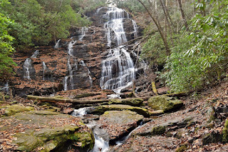
It's a really nice waterfall that fans out and almost appears crooked.

Returning towards the bridge, we followed an old road upstream along Chattooga River a quarter-mile to Chute Falls was visible from the trail.


To get a better view, I made the very steep climb down to the creek.  It was butt-sliding most of the way.  At the creek, I then had to wade to get across for a decent picture.


I think it would have been easier to come up the other side of the river.


After some pictures, I made the super steep climb back up to the old road.  It ended near the top of the waterfall.


Then we hiked back.  On the drive out, we made a stop to see the Wilks Creek Waterfalls.  The upper falls was visible from the road, but it was a very steep scramble down to the creek.  And once down, there was a massive amount of downfall in front of the falls.  So I climbed up a bit for a side view.


Then I scrambled a short ways downstream to the lower falls.


There was more downfall, but easier to get a view from the front.


Then we scrambled back up to the road.  We made one more stop on the way out at the roadside Spoilcane Tributary Upper Falls.


Then we drove back to the paved roads and headed back to Franklin.


For dinner, we stopped at Lazy Hiker and got tacos from the food truck.  Their outdoor seating was artificial grass that's comfortable for Alex to lay on while we enjoyed our dinner and drinks.  Then we went back to the hostel for the night.

Friday, March 28, 2014

More Waterfalls near Helen

Friday was our last full day in Helen and it was a dreary day. But we weren’t going to let that stop us from getting more waterfalls. Our first stop was the DeSoto Falls Recreation Area in Chattahoochee National Forest. From Helen, we got on GA-75 Alt North and followed that to GA-11/US-129 North. The recreation area was about 11 miles down this road. After paying the day-use fee, we started out on the trail amid a heavy fog, though it wasn't raining. According to sign at the trailhead, the waterfall is named for Hernando DeSoto who explored the region in the 16th century. A piece of armor believed to have belonged to the explorer was discovered near the falls in the 1880s. From the trailhead, we first turned left and hiked about a quarter-mile to the lower falls. Just below the lower falls was another smaller waterfall, Hidden Falls.


There was no good viewing spot, but we could mostly see it from the trail. Lower DeSoto Falls was just past this and we could get a good view from a viewing deck at the end of the trail.


After we stopped for Hidden and Lower Falls, we continued the other way on the trail to the Upper Falls, a beautiful multi-tiered waterfall. The highest tier was difficult to see due to the fog, but also gave the waterfall a mysterious and spooky feel.


When we were done, we headed back to the car and headed to our next waterfall. We continued driving north on US-129 and turned right on Helton Creek Road. In about 2 miles, we pulled off to the side of the road and made the short hike up to see Lower and Upper Helton Creek Falls. There is a short trail that leads down from the road and then up towards the waterfalls.


About half way, a staircase leads down to rocks at the base of the Lower Falls.


After we got some pictures from here, we continued on up the trail to the wooden overlook for the Upper Falls.


On the hike back, we could see both waterfalls from some places along the trail, but they were partially obscured by the trees.


From here, we continued on Helton Creek and Hatchet Creek Roads to GA-348 and took this to GA-180 and GA-75 heading back towards Helen. After a couple of miles, we turned onto the gravel Chattahoochee Road (FS-44). Almost immediately, we made a quick stop to see Upper Spoilcane Creek Falls right on the side of the road. It was really foggy and hard to see, so we planned to stop on the way back as well if the visibility improved. We drove a couple more miles and pulled over again. We could hear the two waterfalls on Wilks Creek, but couldn’t see them well. We walked down the road a bit and found a safe place to head down to the creek and then bushwhacked up a bit to see the Upper and Lower Falls on Wilks Creek.


They were both decent-sized waterfalls but the heavy rhododendron prevented us from getting a great view.


From here, we continued down FS-44 to the Upper Chattahoochee River Campground and parked. Despite the poor weather, there were several groups camping here, some of whom had drove campers and RVs. I was impressed that they could get those large vehicles down the narrow, winding gravel forest road. Past the campsite, we first made the short hike to Horse Trough Falls, a beautiful 70-foot cascading waterfall on the headwaters of the Chattahoochee River.


The ledges over which the water cascades are angled, giving the waterfall a “crooked” look to it. When we were done at this waterfall, we hiked upstream along the Chattahoochee River a short ways to Upper Chattahoochee Falls. This is a 20 or so foot waterfall through a narrow sluice.


Here at the headwaters, the mighty Chattahoochee River is only a couple feet wide. We could only see the waterfall from the trail, however. There were very steep paths leading down to the base, but given the wet conditions, getting down would be dangerous and getting back up would be near impossible. So we got a couple pictures from the trail and then hiked back to the car. On the way out, the fog had lightened a bit and we stopped quickly to get a better shot of Upper Spoilcane Creek Falls.


Back on the paved roads, we headed back towards Helen, a little earlier than most nights. We walked around town a bit, hoping to do a bit of shopping. Unfortunately, many stores were closed or had limited hours during the off-season, but we did pick up some goodies from Hansel & Gretel Candy Shop. For our last dinner, we ate at Cowboys & Angels again, having the very tasty Avocado Burger. We even saw some rabbits frolicking amidst the landscaping outside. After dinner, we headed back to the hotel and started getting our stuff packed up. Finishing the way day up, we were at more than 50 waterfalls for the week and still had a few more on our way back home tomorrow.

Monday, March 24, 2014

Amicalola Falls

Monday morning, after we woke up, we asked the hotel staff for recommendations for breakfast and they suggested Hofer’s. This was just a short walk from the hotel so we gave it a shot and really enjoyed their breakfast. So much so that we ended up eating breakfast here every morning of our trip. After breakfast, we got ready and headed towards Dawsonville for Amicalola Falls State Park, home to Georgia’s largest waterfall. We started by driving all the way up to the top and making the short stroll to the bridge at the top of the waterfall.


The views looking out from this point were great, but we couldn’t see much of the falls. So we started making our way down the West Ridge Staircase. Down many, many steps - more than 400. And going down meant we would have to go back up afterwards. But going down was the easy part and we enjoyed the stroll down alongside the mighty waterfall.


At the base of the stairs, the trail runs across a footbridge over the middle of the falls and then down even more stairs to the lower observation platform for a view of the entire 700-foot waterfall.


We stopped for a while to get some pictures and then slowly made our way back up.


Near the top of the stairs, we talked to an older gentleman who was clearly an experienced hiker in the region. He told us to check out the archway for the Appalachian Trail just behind the visitor center. So after we finished the climb and made it back to the car, we made a quick stop at the visitor center to get a picture of the AT archway.


Then we left the park and headed into Chattahoochee National Forest. We took GA-52E to Nimblewill Church Road and turned left at the church to the gravel Nimblewill Gap Road. After about 4 miles, we pulled into a primitive campsite and hiked upstream along Nimblewill and Bearden Creek. There was no official trail, but we could follow old roads up most of the way. We had several stream crossings along the way, but only one near the beginning at Nimblewill Creek where we had to wade.


About half way up the trail, there was a nice waterslide along Bearden Creek and another small waterfall on a feeder stream, although this was very hard to see through the dense foliage.


As we approached the waterfall, the trail became much more steep and narrow. Although we could see the falls through the trees as we climbed up, there were no views where the trail ended. So I climbed down a precarious wet rock and waded across a small pool to a big rock where I had spectacular views of the waterfall.


Although not well-known, this was a really fantastic waterfall.


After a few pictures I had to make the extremely challenging climb back up to the trail. After that, however, it was really an easy and relaxing hike back downstream to the car. And one more stream crossing at Nimblewill Creek near the end. From here, we went back on Nimblewill Gap Road to Nimblewill Church Road, but soon turned off the paved road onto FS-28-1 for a long drive on windy forest roads. At the fork, we went left on FS-77 (Winding Stair Gap Road) and then turned on FS-77A. We were planning to drive down to Jones Creek for Falls Branch Falls, but the road was partially washed out and we didn’t want to risk getting stuck. However, the drive was not totally in vain as we could stop and see a couple of smaller waterfalls on Upper East Fork of Jones Creek. There was no trail, but they were close to a pulloff on the road.


We bushwhacked down to the third waterfall and then made our way back upstream to view the second and first.


Then we drove back to FS-28-1 and followed that to Hightower Church Road (FS-28). We followed this past a couple of military vehicles and Camp Wahsega and stopped at the US Army Ranger Camp Frank D. Merrill. Although this training ground for the elite Army Rangers is restricted at times, they are nice enough to allow public access to the waterfalls when training is not ongoing. From the pull-off, we hiked down the small hiking trail and soon could hear Lower Falls and found a spot where we could bushwhack down to the base. Surprisingly, there was another couple here, but they were just getting ready to go, so we spent a few minutes taking pictures and enjoying the falls.


When we were done, we climbed back up to the trail and followed it a little further to yet another stream crossing. The water level was high and there was no rock-hopping so we had to wade again. From here, we followed a trail upstream along the river until we got close to the training grounds and crossed on a log. As it turns out, we didn’t really need to cross the stream and could have just backtracked from Lower Falls. Just past the training area was Black Falls.


There is a conveniently placed bridge across the river just in front of the falls that allows for good photos. When we were done, we hiked back up the road to the parking area. It was getting late by this time, so we started heading back to Helen. Along the way, we stopped for Mexican at El Campesino in Cleveland, and then headed back to the hotel.