
Hike Length: 2.4 miles
Estimated Time: 1 to 2 hours
Difficulty: Moderate
Estimated Time: 1 to 2 hours
Difficulty: Moderate
Location: Swallow Creek Wildlife Management Area (Blue Ridge Ranger District of Chattahoochee National Forest)
Trail Users: Hiking onlyDogs: Yes
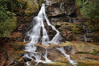
Features: Waterfalls (2)
Crowds: Moderate
Warnings: The rocks around waterfalls are slippery.
Trailhead GPS: 34.81616,-83.72701
Waterfall GPS: 34.82214,-83.72203
Directions:
From Hiawassee, head east on US-76 for about 3 miles and turn right on GA-17/GA-75 south. Go 6.8 miles and turn left onto Indian Grave Gap Road, which becomes FS-238. There is an auto ford of Hiwassee River shortly after the turn, but should be passable in most vehicles except in high water. Continue 1.3 miles from from the highway to a small parking area on the left at the trailhead.
Map:

Hike Description:
From the trailhead, pick up the green-blaze High Shoals Falls Trail (#19) heading down.

The descent is gradual at first then becomes steeper as it drops down to High Shoals Creek at about 0.5 miles. Cross the creek on a footbridge and continue following the trail downstream. At just under a mile, the trail passes a spur on the left to Blue Hole Falls. The trail then descends along High Shoals Falls via switchbacks and ends at a wooden overlook.
Here's a video of the falls.
Blog Entries:
27-Dec-2021: Brasstown Bald
External Links:
GA Wildlife Resources website: https://georgiawildlife.com/swallow-creek-wma
No comments:
Post a Comment