Sunday, October 28, 2018

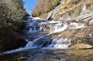
Yellowstone Falls

Sunday morning, I broke camp after waking.  The rest of the group was unsure of their plans so I took off towards Graveyard Fields on the Blue Ridge Parkway.  I managed to get a legal parking spot at the overlook; with little fall color left, Graveyard Fields wasn't as popular as usual.


Hiking down towards the Mountains-to-Sea Trail, I first stopped at Second Falls.  It was sunny and the lighting was poor, but it was really pretty in high water.


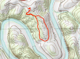
As this one is crowded, I moved on after a few pictures.  I finished up Mountains-to-Sea Access (#358B) and went right to go eastbound on MST.  In about a quarter-mile, I turned right off the trail to a campsite and headed down to the creek above Yellowstone Falls.  Crossing here was tricky in high water and I had to jump to avoid getting my feet wet.  Luckily, the rocks were dry.  On river right, a steep path led down along the falls.  It was little better than nothing and I had to crouch the entire way.  I first came out near the middle.


But there was more waterfall below and it got really steep from this point.  Monkey climbing down the rhododendron was the only way down to the base.


It was still sunny so not great for pictures but a little fall color was showing.  There was even a little rainbow in the spray.


I then made started making my way back.  I must have gotten off the path as it seemed to be even worse rhodos getting back up.  But soon I was back to the creek and then the MST.


My next stop was Bubbling Springs Cascade along NC215.  This is another great area for fall color, but most of the leaves had already fallen.  I climbed down from the road and rock hopped up to the base.


The water was way up, but the sun was shining right on it.  I then headed to the MST parking along NC-215.  Entering Middle Prong Wilderness, I followed Bubbling Springs Branch upstream, which was a little tricky.  I remembered this being easy in the past, but the water level was a lot lower.  Again, the sun was shining right on Lower Bubbling Springs Falls.


So I crossed the creek and climbed further up.  Most of Upper Bubbling Springs Falls was in the shade, so looked a lot better.


After a few pictures, I headed back.  I wasn't quite ready to leave yet, so hiked a short ways on MST eastbound towards Graveyard Fields.  The trail followed a small tributary upstream but it was too small for any major drops.


I took the Blue Ridge Parkway towards Asheville heading home and made a few stops on the way.  East Fork Overlook was right above Yellowstone Falls.


I could hear it down below but it was hidden from view.  Cradle of Forestry Overlook had nice views down the escarpment but color wasn't close to peak yet.


Mills River Overlook was similar.


I made one last stop at Bad Fork Overlook; at much lower elevation, there was little color change.


Then it was a long drive home.

Saturday, October 27, 2018

Remote Nantahala Waterfalls

This past weekend, I headed to the mountains with Casey and Team Waterfall to hit some remote waterfalls in the Highlands area.  I left Friday evening after work and drove to Lazy J's Campground in Rosman.  Christie was already here so we had a fire, but it started raining so went to back to our tents shortly.  Casey, Mike and Joy arrived later in the night.  In the morning, Badger and Kitty met us at the campground and we followed them to Nantahala National Forest and the trailhead for Cane Creek Falls off Whiteside Cove Road.  We started off hiking down gated Forest Road 2052.  A huge snail was along the road near the start.


In about a half-mile or so, we got off the trail and bushwhacked down towards Cane Creek.  It was easy at first but got real steep towards the end.  Coming out at Cane Creek downstream from the falls, we scrambled up the creek to the base.


Cane Creek Falls is a really beautiful waterfall.  But after some pictures, we headed back as there were several more on the agenda.


Driving further into the forest, our next stop was Little Creek Falls off Rich Gap Road.  A short hike up another gated road - FR-4622 - led to a sharp right where we got off the trail and bushwhacked down towards the falls.  As we got to the waterfall, we ran into Professor Scott as Team Waterfall was really coming together.  Bushwhacking towards the creek, we came to a spot in between an upper and lower section of the waterfall.  I first went to the upper section but it was difficult to get a good photo as there was a lot of branches and downfall in the way.


It was then a very steep climb down to the lower section.  I thought this was the most scenic part of the waterfall, with scenic little cascades just down from the falls.


Overall, I wasn't expecting to be impressed, but Little Creek Falls was a lot better than expected.  After a bit. we bushwhacked back to the road and cars.


Our next planned waterfall was Chasm Falls, but Badger and Kitty wanted to show us a discovery they had made first.  Driving into the Blue Valley area, we parked along Forest Road 79C, down below Glen Falls.  An unmarked tributary flowing down from Chinquapin Mountain had a waterfall and we could see it from the road.  But there was no trail so it would be all bushwhacking.  It was a real steep and overgrown bushwhack up the unnamed tributary.  As we got close to the falls, dense rhododendron prevented easy access.  Climbing up and around, we found a break in the bushes and got through to come out near the top of Chinquapin Falls.


Unfortunately, a huge tree had fallen down right across the waterfall.  That won't be going anywhere for a while.  Climbing down near the base of the upper drop, it was too cluttered for much of a picture.


We climbed down a bit on the other side and came out at another nice drop.  This thing kept going and going but it was too overgrown for a picture.  Crossing the tributary here, we were able to bushwhack back and find our way back down the mountain.


We had one more waterfall for the day - Chasm Falls on East Fork Overflow Creek and the trailhead was just a short drive past the Picklesimer Rock House Falls trailhead.  Spencer, Carlos, and Emily were here, quite the Team Waterfall meetup.  After greetings, we followed an old road led to the creek near the top of Chasm Falls.


The waterfall was quite impressive, as was the narrow chasm through which it flowed.  I decided not to cross the creek to the base as I didn't want to get my feet wet since it was getting late.  Probably a good idea as Emily fell in and had to be rescued by Casey.


After everyone was finished, we headed into Cashiers for dinner and then back to camp.

Saturday, October 20, 2018

Early Fall Color in the High Country

Saturday, we took Alex to the High Country for some early fall colors.  We left around 6 and made it to Elk Knob State Park before 930.  First, we got Alex's passport stamped at the park office then headed to the trailhead parking.


It was lightly raining when we started and very cloudy so didn't look hopeful for great views.  We hiked up the Summit Trail to the top of Elk Knob at over 5500 feet.  Although there was some color at the top, it was too cloudy to see much of anything.


There were a couple little flurries of snow mixed in with the drizzle.  At the south overlook, it was just as foggy and nothing to see, so we started hiking back down.


Once finished, we made the drive over to Mount Jefferson State Natural Area.  Again, we parked at the office and got Alex's passport stamp.


Then we started hiking up the Mountain Ridge Trail.  It was cool enough that the steep uphill didn't seem to bad.  In about a mile, the trail came out at Sunrise Overlook.


The clouds had cleared enough that we had nice views and sky was really cool looking.  Continuing on the trail, we roughly followed the road up to Jefferson Overlook.


This overlook had great views of West Jefferson below and the Blue Ridge Mountains all around.  At this point, we had to scramble up some rocks to continue on the trail.


Alex wasn't too pleased about this part, but he made it up and we came out at the upper parking lot.  From here, we took the Summit Trail up to the top, thought there aren't great views from Mount Jefferson itself.


Continuing on, the Rhododendron Trail led along some cliffs and out to Luther Rock, which does have great views.


It was still partly cloudy, but had cleared enough for some real nice views of early fall color.  Strange that over half way through October and the foliage wasn't yet peaking even here in the High Country.  We took the Lost Province Trail to extend our hike a bit.


At the end of the loop, Rhododendron Trail brought us back to the picnic area at the upper parking lot.  On the way down, I took a detour on the Spur Trail out to Sunset Overlook.


This one had similar views to Jefferson Overlook but from a lower perspective.  The spur was all uphill back to Mountain Ridge Trail, but then it was all downhill from there.  The clouds had cleared a bit more so I stopped one more time at Sunrise Overlook.


It was then less than a mile from here back to the car.


Our next stop was New River State Park.


We wanted to get another passport stamp but the visitor center was closed and I couldn't find an outdoor one.  Since we were here, we hiked the 1-mile Hickory Loop then took off.


Not wanting to leave without at least one waterfall, we made a quick detour to Riverview Falls.  It's pretty nice for a roadside waterfall.


There was a lot of downfall, but it had several sections as was better than expected.


After a couple pictures, we took off and headed home.

Saturday, October 13, 2018

Independence Waterfall

Saturday, we were flying home.  But before leaving, we had to get one last waterfall.  Independence's Waterfall Park was just a couple miles from the hotel so we headed there.  Despite the name, there's not a waterfall in the park itself, which is right on the lake.


We followed the Waterfall Park Trail south from the park to E Bluff Drive and walked in the northern lane, which is blocked to vehicular traffic.  It was just a short ways to the waterfall.


Right next to the road, it's very scenic though I think it's man-made.  Since one lane is blocked, you could only see it from a car driving eastbound on E Bluff Drive from the park.  After a few pictures, we hiked back.


I saw another Osage orange along the ground that we had seen in Sedan - a very strange fruit.  Back at the car, we finalized packing all our stuff and then drove to the airport to head home.

Friday, October 12, 2018

Ha Ha Tonka

Friday, Lil made us a delicious breakfast and we chatted with her for a while before taking off.  After packing up, our destination for the morning was Ha Ha Tonka State Park and we parked at the trailhead Ha Ha Tonka Oak Woodland Nature Area for Devil's Kitchen Trail.  It was lightly drizzling at this point but not too hard.  Heading out through the woods, we passed through an open glade and then back into the woods as the terrain became more rocky.  Soon, there was a crevice in the ground.


Past here, we came to the Devil's Kitchen, a shelter cave inside a sinkhole.  The crevice above was a chimney in the back of the cave shelter.


Continuing on the trail, we had to jump across a crack in the ground.


At this point, we had entered the Devil's Promenade, a massive concave bluff.


The trail then came out to the road near the old post office and crossed the street, heading down to lake level along the white connector.  A bridge crossed the shallow lake arm and we hiked the Island Trail.


The trail initially went up to the center of the island at Balancing Rock.


Past here it descended down towards the lake again where the water was a beautiful turquoise color.  The water cascaded over the ruins of an old dam.


Continuing on, the trail looped around the island.  I spotted some sulphur shelf mushrooms growing on a log.


We followed the trail around the island and back across, following Spring Trail to the Ha Ha Tonka spring.


The water came out of a cave and flowed into the lake, the source of the lovely turquoise water.  From here, we had to climb up a tall staircase up to the rim and followed Dell Rim Trail.


There was a parking lot here, and the Carriage House Ruins were right next to it.


We saw the other couple from Bridal Cave here and then an overlook to see down to Lake of the Ozarks and the island from earlier in our hike.


Just past here was the park's signature attraction - Ha Ha Tonka castle.


Built in the early 20th century, it had been destroyed by a fire and all that was left was the stone ruins.


But it was still really cool and seemed like it belonged in Europe, not Missouri.  Near here was a stone water tower, which also had been destroyed by a fire.


It was just a short walk back to the car, but first we got on the Colloseum Trail and hiked under the natural bridge.


There sure are a lot of cool geological features in this part of Missouri.  The Colloseum was a wide bowl of steep rock walls that the trail led around.


Finishing up the loop, we hiked back to the car and departed.


Driving north we stopped for lunch at New China and then continued to Rock Bridge Memorial State Park near Columbia.  The short Devils Icebox Trail led first to the Rock Bridge.


The creek made an impressive cave through the mountain and we climbed down to go under the bridge.  It's big enough that it was pretty dark in the middle.


Where the creek flowed in, there was a small waterfall right in the cave.  Continuing on, we climbed down to the entrance of Devils Icebox and Connors Cave.  Although visitors are allowed in the cave, we didn't have the right gear.


And with the light rain, the water level was up and would have been dangerous to go far.  But it was a really cool area.  Before leaving, we hiked the Sinkholes Trail.  Most of the sinkholes were dry and not real noticeable, but there were a couple wet sinkholes.


There was also an old tower and farm pond, evidence of the area's agricultural past.


We finished up the loop back at the parking lot.


From here, we headed back towards Kansas City and checked in to the Hilton Garden Inn at Independence.  For dinner, we had BBQ at Jazzy B's and then started packing for tomorrow's flight.