Tuesday, we checked out of the hotel and headed east towards Missouri. Crossing the state line near Joplin, we got off the interstate for our first waterfall in Missouri. Grand Falls is right along the side of the road. It's only 12 feet high, but over 100 feet wide.

There are a lot of rocks at the base to climb around and view the falls from different angles. A dam is just above the falls and only the lower section is natural.

It's a real scenic area and we enjoyed scrambling around on the rocks.

Grand Falls is the largest continuously flowing waterfall in Missouri; many are seasonal and dry up completely. We'd find a couple of those.

After some pictures, we continued into the Ozarks towards Roaring River State Park. The park is stocked with rainbow trout so very popular with fishermen. The river itself was a really beautiful color.

Parking across the river from the lodge, we first hiked the Devil's Kitchen Trail. Shortly we came to a split and went right to follow the loop counterclockwise. Numbered stakes along the trail correspond to points of interest and we were following them in order, but didn't have the trail guide yet. The first station was for the Bench, an area of dolomite that is a more erosion-resistant form of limestone.

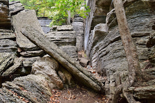
Just off the trail were limestone cliffs that had eroded to form horizontal cracks. The cracks were very straight and some almost appeared to be man-made. There were several small caves along the cliffs. Station #2 marked a shelter cave that had been used by Native Americans for thousands of years.

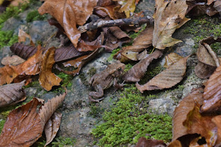
A little toad was just off the trail near here.
At station #3 was a lignite cave and this one was pretty deep. The ceiling was narrow and I didn't want to crawl in there - it was very dark.

After this point, the trail looped back around to lead around above the bench and ascended to a ridge where it was pretty flat. We could see the entrance road to the park from here. A good number of wildflowers were blooming up here.

Several different species of asters and a few goldenrod.

The trail then passed through a pine woodland and led down to the bench again. A small trailside spring cave was here with just a little water coming out.

Above the cave were more of the limestone cliffs that characterize the bench.

These cliffs were really scenic and looked like they would be good for rock climbing with lots of horizontal cracks to grip.

Just past here was the Devil's Kitchen at stake #9. The cave had collapsed in recent years but it was really cool to see the huge boulders that had made a "room" in the limestone.
Those collapsed rocks were really huge - good thing nobody was in there when they fell. A little bit past here, there was a little fence lizard along the trail.

Finishing up the loop, we stopped by the park office to pick up the trail brochure so we could identify the different stations in retrospect. We were heading to Branson, but wanted to get another hike in before we left, so hit the short River Trail that started right by the amphitheater. There were more wildflowers blooming as we hiked along the trail and the calico aster were really pretty.

And there was a big yellow garden spider at one point with its signature zigzag web.

He was kind enough to keep it off the trail though. This trail also led next to another rock wall and many plants were growing out of the side.

The geology in this area is really amazing! The trail ended at a fishing spot on the river and we turned around here.

From Roaring River, we drove to Branson and parked at the Ruth and Paul Henning Conservation Area. This small natural area protects a beautiful landscape of glades around Dewey Cove.

We hiked the Glades Trail through and open area and then turned right on Streamside Trail. In the dry tributary was a little turtle.

We turned right again on Shane's Shortcut and it was just a short ways to Dewey Cove, where there's a waterfall when the water level is up.

But there was absolutely no water flowing today. It was still a nice area through and worth a stop. Heading back, we went the other way on the loop trails.

The views of the glade were really scenic and its a very different type of landscape than we're used to. Further along Glade Trail was a wood overlook for a view of the glades.

Before leaving, we hiked the paved trail up to the lookout tower at the summit of Dewey Bald. Climbing up to the top, there were nice views of Branson and I could see a storm moving in.

From here, we headed back to the car. We had one more waterfall to visit and it was just a short drive to the trailhead for Branson's Waterfall Trail. The rain was starting so we donned rain jackets. The rain picked up as we hiked the short trail, but plenty of rock overhangs provided shelter along this unnamed tributary of Roark Creek. We saw a few cascades along the little stream.

Some wildflowers were blooming, but I didn't get my camera out much in the rain.

At one point, there was a bright flash of lightning and loud bang of thunder. Another couple hiking back were carrying umbrellas, probably not the smartest thing in a thunderstorm. Conveniently, there was an overhang right near the base of Cotton Rocks Falls so we waited here for a bit.

When the rain died down some, I ran out to get a couple pictures, then got back under the shelter when it picked up again. It didn't look like it was going to lighten up much, so we just headed back.

It was getting late now, so we headed to the Stone Castle hotel and checked in. The rain did not relent, but we were hungry, so headed to Danna's BBQ for dinner. After dinner, we thawed out in the hot tub and went to bed.

There are a lot of rocks at the base to climb around and view the falls from different angles. A dam is just above the falls and only the lower section is natural.

It's a real scenic area and we enjoyed scrambling around on the rocks.

Grand Falls is the largest continuously flowing waterfall in Missouri; many are seasonal and dry up completely. We'd find a couple of those.

After some pictures, we continued into the Ozarks towards Roaring River State Park. The park is stocked with rainbow trout so very popular with fishermen. The river itself was a really beautiful color.

Parking across the river from the lodge, we first hiked the Devil's Kitchen Trail. Shortly we came to a split and went right to follow the loop counterclockwise. Numbered stakes along the trail correspond to points of interest and we were following them in order, but didn't have the trail guide yet. The first station was for the Bench, an area of dolomite that is a more erosion-resistant form of limestone.

Just off the trail were limestone cliffs that had eroded to form horizontal cracks. The cracks were very straight and some almost appeared to be man-made. There were several small caves along the cliffs. Station #2 marked a shelter cave that had been used by Native Americans for thousands of years.

A little toad was just off the trail near here.

At station #3 was a lignite cave and this one was pretty deep. The ceiling was narrow and I didn't want to crawl in there - it was very dark.

After this point, the trail looped back around to lead around above the bench and ascended to a ridge where it was pretty flat. We could see the entrance road to the park from here. A good number of wildflowers were blooming up here.

Several different species of asters and a few goldenrod.

The trail then passed through a pine woodland and led down to the bench again. A small trailside spring cave was here with just a little water coming out.

Above the cave were more of the limestone cliffs that characterize the bench.

These cliffs were really scenic and looked like they would be good for rock climbing with lots of horizontal cracks to grip.

Just past here was the Devil's Kitchen at stake #9. The cave had collapsed in recent years but it was really cool to see the huge boulders that had made a "room" in the limestone.

Those collapsed rocks were really huge - good thing nobody was in there when they fell. A little bit past here, there was a little fence lizard along the trail.

Finishing up the loop, we stopped by the park office to pick up the trail brochure so we could identify the different stations in retrospect. We were heading to Branson, but wanted to get another hike in before we left, so hit the short River Trail that started right by the amphitheater. There were more wildflowers blooming as we hiked along the trail and the calico aster were really pretty.

And there was a big yellow garden spider at one point with its signature zigzag web.

He was kind enough to keep it off the trail though. This trail also led next to another rock wall and many plants were growing out of the side.

The geology in this area is really amazing! The trail ended at a fishing spot on the river and we turned around here.

From Roaring River, we drove to Branson and parked at the Ruth and Paul Henning Conservation Area. This small natural area protects a beautiful landscape of glades around Dewey Cove.

We hiked the Glades Trail through and open area and then turned right on Streamside Trail. In the dry tributary was a little turtle.

We turned right again on Shane's Shortcut and it was just a short ways to Dewey Cove, where there's a waterfall when the water level is up.

But there was absolutely no water flowing today. It was still a nice area through and worth a stop. Heading back, we went the other way on the loop trails.

The views of the glade were really scenic and its a very different type of landscape than we're used to. Further along Glade Trail was a wood overlook for a view of the glades.

Before leaving, we hiked the paved trail up to the lookout tower at the summit of Dewey Bald. Climbing up to the top, there were nice views of Branson and I could see a storm moving in.

From here, we headed back to the car. We had one more waterfall to visit and it was just a short drive to the trailhead for Branson's Waterfall Trail. The rain was starting so we donned rain jackets. The rain picked up as we hiked the short trail, but plenty of rock overhangs provided shelter along this unnamed tributary of Roark Creek. We saw a few cascades along the little stream.

Some wildflowers were blooming, but I didn't get my camera out much in the rain.

At one point, there was a bright flash of lightning and loud bang of thunder. Another couple hiking back were carrying umbrellas, probably not the smartest thing in a thunderstorm. Conveniently, there was an overhang right near the base of Cotton Rocks Falls so we waited here for a bit.

When the rain died down some, I ran out to get a couple pictures, then got back under the shelter when it picked up again. It didn't look like it was going to lighten up much, so we just headed back.

It was getting late now, so we headed to the Stone Castle hotel and checked in. The rain did not relent, but we were hungry, so headed to Danna's BBQ for dinner. After dinner, we thawed out in the hot tub and went to bed.
No comments:
Post a Comment