Saturday, May 30, 2015

Doughton Park Training Hike

This past Saturday, we headed up to Doughton Park along the Blue Ridge Parkway for a long conditioning hike as we get ready for our trip to Glacier National Park. We met in Chapel Hill at 7 and carpooled out to the trailhead on Long Bottom Road, arriving right at 930. After getting our stuff together, we started out our hike along Grassy Gap Road. Almost immediately, we turned right to head up Cedar Ridge Trail. And up and up! The trail is quite steep and wastes no time heading up. Although the temperatures were mild today, the humidity was intense down in the gorge and soon we were all dripping with sweat. Fortunately, the mountain laurel that was blooming along the trail providing a much needed distraction (and opportunity to stop for pictures).


The going was slow until we reached the end of Cedar Ridge Trail. At this point, we turned left to get on the Mountains-to-Sea Trail, which runs concurrently with Bluff Mountain Trail, roughly following the Blue Ridge Parkway southbound. Although the trail had some ups and downs, it was much more level than the hike up to this point. Moreover, the humidity dropped as we hiked up out of the gorge and there were nice breezes to cool us off.


We hiked past some lovely wildflower meadows and through the campground and stopped briefly to replenish our water. We had drank a lot hiking up. Then, we continued following the trail, crossing the parkway several times. At one spot, it crosses the parkway at Low Notch, a nice spot with scenic views of the gorge and foothills below.


Up at this elevation, we saw more rhododendron and flame azaleas than mountain laurel.


After passing the closed gift shop, we got off the trail and hiked up past the lodge to Wildcat Rocks Overlook and stopped here to eat our lunch.


The views here are fantastic and it was a great spot to sit and eat. Far below, we could see Caudill Cabin deep in the Basin Cove Valley.


And there was some spider wort blooming right by the overlook.


After lunch, we headed back towards Bluff Mountain Trail. A beautiful patch of flame azalea was blooming along here.


We stopped for some pictures and then got back on Bluff Mountain Trail and continued hiking southbound. Much of this area is bald and so the views over the valley are wonderful. We saw a herd of cows grazing at one point, helping to keep the vegetation down. We also saw an interesting lone tree standing near Bluff Mountain.


I pointed this tree out to Sandy as we would be able to see it from a distance much further along in our hike.


Soon, we made the easy climb up to the summit of Bluff Mountain and then headed back down via a number of switchbacks. The trail continues to follow the parkway southbound, but through more forested areas so no more sweeping panoramic views.


We did see a number of wildflowers blooming in the area, including bright red fire pink and the purple Virginia waterleaf.


When we reached the Basin Cove Overlook, we turned onto Flat Rock Ridge Trail to head back to the parking area. The trail descends for a while, then starts heading back up to near the summit of Flat Rock Ridge. Near the top, there was a break in the trees and we could see across the gorge.


Far in the distance, we could see that lone tree that we passed several hours earlier. After this point, the trail is all downhill back to the parking lot.


The trail is forested so no sweeping views, though we did see some more mountain laurel blooming. On our way home, we stopped at Kiosko in Greensboro for Mexican for dinner.

Monday, May 25, 2015

Toms Spring & Shuck Ridge Creek Falls

Monday morning, we had breakfast at the hotel and then packed up our stuff and checked out. We headed back to Pisgah Forest one more time. On FSR-475, we continued past Cove Creek Group Camp and parked at the trailhead for Toms Spring Falls. There are a number of primitive camping sites along FSR 137, so the parking lot was almost full. After getting our stuff together, we hiked across Davidson River on the bridge and turned right on FSR 5046. It was just a short ways to Toms Spring Falls.


First, we got some pictures from the road, then climbed up the rocks and got some pictures up close.


After a few minutes, we backtracked a short ways and turned right to get on Daniel Ridge Loop Trail (#105). Initially, the trail is quite steep as it ascends to the top of the Toms Spring Falls via a couple switchbacks. Then it leveled off a bit, following Toms Spring Branch upstream. The trail varied from mostly level to a little steep, but it wasn’t too hot today, so didn’t seem bad. And the mountain laurel were in full bloom along the trail, which made for a beautiful sight.


We also saw a cute little snake right along the trail. He didn't seem to be bothered by us and kind of looked like he was grinning.


In a little over two miles, the trail split – Daniel Ridge Loop Trail continued to the left and Farlow Gap Trail (#106) went right. We turned right, initially climbing steeply up via switchbacks as we got above Right Fork. The trail curved around a ridge, crossed Daniel Ridge Creek, and then curved around another ridge as it approached Shuck Ridge Creek.


We crossed the creek and then took the extremely steep and slippery path down to the base of Shuck Ridge Creek Falls. The last time I was here, it had been raining and the rocks were slick. I hoped they would be dry this time as it hadn’t rained in a while, but no such luck. Shuck Ridge Creek is not a big waterfall, but it’s a pretty one, with an hourglass shape and the setting of the falls is lovely.


At the base of the falls, we had a snack and got some pictures before making the treacherous climb back up.


Once up from the waterfall, it was mostly all downhill from here. When we got back to Daniel Ridge Loop Trail, we turned right to finish up the loop and hike FSR 137 back to the car. Overall, it was successful long weekend.


Even with the difficulty in finding accommodations, we still managed to get 17 waterfalls in three days. On the way home, we had stop at Las Salsas in Morganton for a delicious meal of fajitas!

Sunday, May 24, 2015

Pisgah Forest & Shining Rock Waterfalls

Sunday morning, we woke up and had breakfast at the hotel. Once we were ready, we headed to the Pisgah Center for Wildlife Education and Fish Hatchery, stopping at Subway to pick up lunch on the way. I was worried that the parking area would be full, but fortunately it wasn’t too crowded here.


We started hiking Cat Gap Loop Trail (#120) for about a mile or so to our first waterfall of the day – Waterfall on Cedar Rock Creek.


The waterfall was very scenic and the mountain laurel was blooming all around the falls. Sandy and I spent some time here climbing around on the rocks and getting photos. It's not a big waterfall, but the setting is really pretty.


From here, we got back on the trail and continued a short ways further on Cat Gap Trail. Just past an occupied campsite, we turned right on the blue-blazed Butter Gap Trail (#123). This trail starts out running through Picklesimer Fields where more mountain laurel was blooming. In Grogan Creek, we saw what we thought was a beaver, but he disappeared under the water before we could get a good look. Past the fields, the trail continues to follow Grogan Creek upstream. In about a mile from the start of the trail, we took a short side path to Waterfall on Grogan Creek.


I hadn’t been to this one before, but it was a pleasant surprise. It’s not a big waterfall, but really pretty with the water tumbling down numerous rock ledges.


We got some pictures and then started hiking back. Once back to the cars, we continued on FSR 475 to the gated FSR 5095. We parked here and hiked along the gated forest road. It was about a mile to where the road crosses Long Branch and here we scrambled up a steep path to Long Branch Falls. The water level was lower than the last time I was here and I was able to carefully climb out onto the rocks at the base for some pictures.


Once we were finished, we hiked back to the car. We continued driving FSR 475 until we reached NC-215 and headed north. About 2 miles before reaching the Blue Ridge Parkway, we turned left on FSR 4663 and drove to the intersection with FSR 4663B and parked. We hiked down the rest of this forest road, though we could have probably driven it without a 4WD as the Forest Service suggests.


At the end of this road, there were three paths. We took the path leading straight ahead and followed it to the base of Dill Falls. Another couple was here taking pictures, so we ate our lunch while enjoying the view of the waterfall. By the time we finished eating, the other couple were starting to head back.  I mentioned to them before they left that there is another Upper Falls here in case they were interested in seeing that one too. We climbed around at the base of the falls getting pictures.


Again, the bright sunny day made for beautiful weather, but not so great pictures. It’s a shame, because Dill Falls is a really beautiful waterfall. Once we were done here, we headed back to where the three paths split and took the one to the right (if looking from the end of FSR 4663B) and headed up the jeep mounds. Once the trail leveled off, flagging tape marked a path to the left that led to Upper Dill Falls. This waterfall is not nearly as big as the lower falls, but it’s still quite scenic.


After a few pictures, we headed back and walked the forest road to the cars. We turned left on NC-215, crossed under the Blue Ridge Parkway and pulled off in about a half-mile at a large parking area on the left. From here, we walked down the road a short ways and then ducked into the woods at a Mountains-to-Sea Trail post and entered Middle Prong Wilderness Area. We initially crossed a creek and then crossed over Bubbling Spring Branch. Once across, we turn left to get off the MST and hiked to a campsite. From here, we crossed the creek again and continued to follow it upstream. There were another three or four creek crossings and eventually we just rock-hopped up the creek to the base of Lower Waterfall on Bubbling Spring Branch.


The water cascades down a steep rock face about 20 feet to a pool then slides down a few more feet. The water level was a little low, so I think this would have been more impressive in higher water level. It looked like the first drop would be split into two streams if there was more water. After a couple pictures, we climbed up the left side of the waterfall and then rock-hopped upstream a short ways to Upper Waterfall on Bubbling Spring Branch.


This waterfall slides down a rock face about 30 feet, but again the water level was kind of puny. We got a couple pictures and headed back. I was planning to get Wildcat Falls next, but the camping area at the trailhead was full and there was nowhere to park. So we continued another mile or so to a pull-off at Bubbling Spring Branch Cascades. We parked here, went under the guard rail, and made the steep climb down to creek level. We crossed the creek and came out at the base of the waterfall. For being somewhat visible from the road, this was actually a pretty nice waterfall. I imagine this would be a fantastic place for swimming when the weather is a little warmer.


After a few pictures, we started climbing back up. Sandy saw something scurrying on the ground and it turned out to be a little shrew.


After climbing up to the road I looked back across to the waterfall from the pull-off along the road. The view here is somewhat obscured by foliage, but I’d imagine in the winter there would be nice views from here. We decided to call it a day after this waterfall and started making our way back. For dinner, we stopped at Twin Dragon Grand Buffet and tried to make up for all the calories burned today! After dinner, we headed back to the hotel and went to bed.

Saturday, May 23, 2015

Birthday Waterfalls

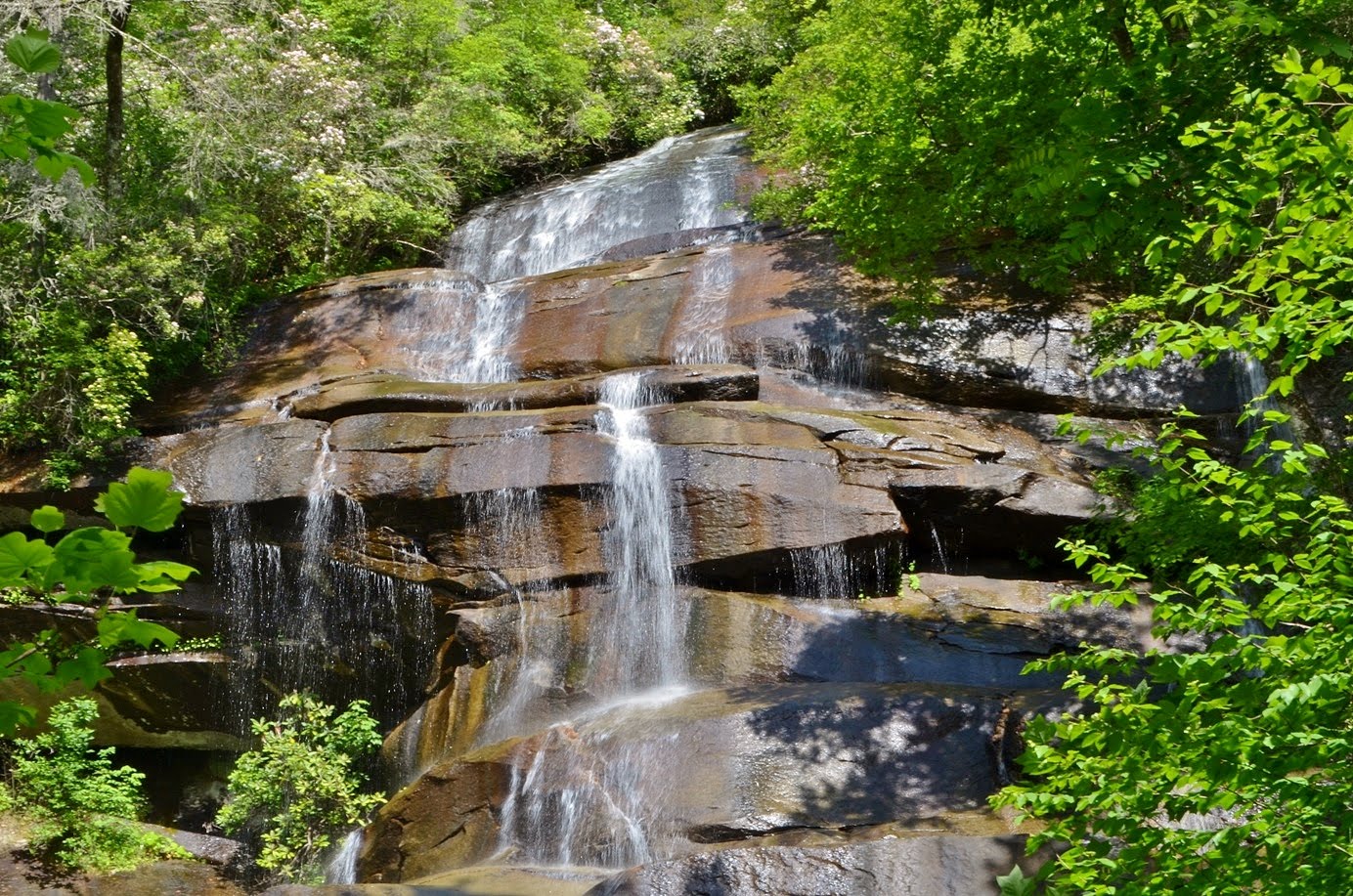
This is the last time for a few years that my birthday falls on Memorial Day Weekend, so Sandy and I headed out to the mountains for the long weekend to get some waterfalls. We left Friday night and drove out to the Brevard area. It turns out there was a festival in Brevard over the holiday weekend, so everything in the area was packed. We finally found a spot along Cathey’s Creek Road to spend the night. Saturday morning, we woke up and headed into Brevard for breakfast and then into the National Forest along US-276. In about 10 miles, we turned right on Yellow Gap Road (FSR 1206) and drove for about 3 miles, then turned right on Wolf Ford Road (FSR 476). Even here, all the campsites were occupied. At the end of the road, we parked and started hiking down South Mills River Trail (#133). In about a mile, the trail turned right to cross South Fork Mills River on a bridge. We got off the trail here and followed an unofficial trail across Billy Branch and continuing to follow the river downstream. The river and trail eventually curved to the left and the trail ended at a river crossing. A rope was strung across to assist wading the river. Once across, the trail continued for maybe another quarter-mile and then a short path led down to the base of the waterfall. Despite the name, High Falls is not particularly high.


It’s only about 15 feet, but rather named as the highest waterfall on this stretch of river. To get a decent shot of the falls, I had to wade into the middle of the river. The water was very cold, but some rocks provided a spot to get out of the water for taking photos.


When we finished here, we started making our way back, having to wade the river again. When we got back to Billy Branch, after crossing the creek, we turned right and followed a faint path upstream for a few minutes to Waterfall on Billy Branch.


This is a very scenic and relatively unknown 20-foot waterfall and definitely worth a quick detour from the route to High Falls. In fact, I think it was more scenic than High Falls. After a few minutes, we headed back and finished the hike back to the car. Back at the car, we returned to US-276 and turned right and headed up to the Blue Ridge Parkway. We got on the parkway heading south and went a few miles to the Graveyard Fields Overlook.


Not surprisingly, the parking area was full and parked cars were spilling out onto the roadway. We found a parking spot and then hiked the Graveyard Fields Loop Trail (#358) in the clockwise direction. Along the way, we saw some beautiful painted trillium blooming along the trail.


Once across Yellowstone Prong, we turned left to get on Upper Falls Trail (#358A). In about three-quarters of a mile or so, we got to the end of the trail and climbed up and over the rocks to the base of Upper Falls. It’s a nice waterfall, but the direct sunlight on the water and rocks made for difficult pictures.


Throughout the weekend, we had the most beautiful weather with pleasant temperatures and blue skies. Unfortunately, this is not ideal weather for waterfall photography. Moreover, the area was extremely crowded and we had to wait in line to get pictures. This was the last waterfall I needed to complete the WC100 challenge, so of course I needed a few pictures. After some pictures at the waterfall, we headed back and then continued the Graveyard Fields Loop Trail. When we had almost finished the loop, we turned onto Mountains-to-Sea Access Trail (#358B) and took the stairs down to Second Falls. Like Upper Falls, this waterfall was extremely crowded and some people were even swimming at the base.


The water was way too cold for me, so I climbed out on the rocks and got a couple pictures and then we headed back to the car. We continued driving south on the Blue Ridge Parkway, and got off on NC-215 north. We drove about 4 miles and parked at a sharp left-hand turn. I was certain at least this area of the forest wouldn’t have people, but I was wrong! There were two cars already parked here. From the pull-off, we saw a couple coming back down to the road and then we headed up the steep path. At the top, the path leveled off and followed Sam Branch upstream. At the upper portion of Lower Waterfall on Sam Branch, we stopped for a bit to get some pictures and climb around on the rocks.


Then we crossed the creek and followed the path to Waterfall in Wash Hollow. Another couple was here enjoying the falls.


Waterfall in Wash Hollow is a pretty cool waterfall, with the water sliding down a steep rock face about 50 feet. There was an additional stream of water flowing down to the right of the main stream, but it was hard to get a good photo. After a couple pictures, we started heading back. Before crossing Sam Branch, we scrambled down to the lower part of the Waterfall on Sam Branch.


I think the view from down here is the best of this falls and a big old log here makes for cool pictures. We crossed back and climbed up to the path and followed it back to the car. Continuing just a short ways on NC-215, we wanted to stop at Waterfall on West Fork Pigeon River, also called Sunburst Falls. The small parking area on the side of the road was completely full, so we had to drive a little further to another pull-off and walk back up the road. We climbed down to river level below the falls and got some pictures of the waterfall flowing under the scenic High Arch Bridge.


It was crowded down here, though, so after a couple of pictures, we headed back. By this point, we had given up on finding a camping spot, so we headed to the Hampton Inn at Brevard to try and get a room. I wasn’t too surprised when they said they were full. So we sat in the parking lot and tried to call around to other hotels in the area. Finally, we found one with vacancy – Mountain Inn and Suites near the Asheville Airport. We checked into our room and then headed back to Pisgah Forest, where Sandy bought me birthday dinner at Hawg Wild. After dinner, we headed back to the hotel and went to bed early.

Sunday, May 3, 2015

Pitcher Plants at Horseshoe Lake

On Sunday, Sandy had the day off and the weather forecast looked fabulous, so we took the kayaks out to Horseshoe Lake in Suggs Mill Pond Game Land. We got on I-95 south and took exit 49 to NC-53 east. In about 15 miles, we turned on to Live Oak Methodist Church Road right after the water tower and continued to Suggs Mill Pond Game Land. Although this place is rather remote, there were quite a few other vehicles here, so clearly we weren’t the only people who wanted to paddle the lake today. Even before putting in, we saw a blooming pitcher plant right by the water’s edge.


The water level was higher than when I had been here in the past and reached almost up to the dock. We got in our boats and started paddling out on the water. We initially paddled to the west, where the lake is more swampy.


There were a ton of cypress trees sticking out from the water and the lake’s surface was covered in fragrant water lilies.


It was still early to see the lily pads in peak bloom, but we did find a few beautiful flowers. There were also some nice patches of blooming pitcher plants in this area.


We paddled around this area, exploring for a bit, then headed over to the main part of the lake. The water is more open here with cypress trees mainly along the shore.


We paddled out about half way across the lake and stopped for a bit to have a snack. Then we paddled some more along the shoreline and found some more great patches of pitcher plants.


They’re easy to find as the bright yellow of the pitchers and flowers stands out in contrast to the green of other vegetation. The flowers on these plants are really interesting - the flower has five petals with an umbrella-shaped structure in the middle.


Looking straight on, it appears to be solid, but looking from the side, I could see that it was like an umbrella. At one point I was right in the midst of the pitcher plants and a fly was buzzing around my head.


I thought to myself that isn’t a very safe place for a fly and that he would likely end up as lunch for one of these carnivorous plants.


The sun was quite bright and there was no adequate shade, so after a while, we paddled back to the dock to finish our kayaking adventure.