Saturday we had breakfast at camp and headed south on Skyline Drive. The rest of the group was doing Old Rag, but we couldn't take Alex on those trails, so headed out for some waterfalls instead. We made a stop at Pass Mountain Overlook for a nice early morning view.

Then we made one more stop at Hazel Mountain Overlook, where we could see clouds over the foothills below.

From here, we continued on to our destination for the day - White Oak Canyon. Parking at Hawksbill Gap, we started off hiking down Cedar Run Trail. The trail followed its namesake creek steeply downhill. With all the recent rains, the creek was really flowing, even up near the top.

There were a lot of nice drops along the creek, a few that might be considered a waterfall. One in particular was especially nice with the water flowing down in three streams over a mess of huge boulders.

I called this one Cedar Run Canyon Falls as it was nice enough to deserve a name. Another cascade was flowing enough to generate a small rainbow.

Soon we came to the top of Upper Cedar Run Falls. There were some nice cascades above and a couple guys were swimming here. Looking downstream, the water fell through a narrow canyon. Continuing on the trail a short ways, we scrambled down to the base.

It's a really cool waterfall flowing through a very narrow canyon. We saw the two guys from the top later on and suggested this as a good place to swim. It wasn't much further to the Middle Falls and we came out at the top again. In high water, we had to wade across the creek and climb down the rocks on the opposite side.

After a few pictures, we crossed back to get on the trail. It was just a short ways further to the lower falls, but a very steep climb down the bank to the base. Lower Cedar Run Falls was really beautiful and worth the difficult climb down.

On the way back up, I spotted an American Giant Millipede scurrying along a rock.

Shortly after this point, we ran into a volunteer with PATC who recommended we avoid the Link Trail and instead stay on Cedar Run Trail to the end at Whiteoak Canyon Trail. We had to cross Cedar Run at a spot that was tricky in high water, but we managed to keep our feet dry (except Alex). There was some nice cascades upstream.

Shortly after this point was the split and we took the guy's advice. When we reached the point where the Link Trail meets Whiteoak Canyon Trail, the wade would have been difficult so appreciated the advice. Now we were following White Oak Canyon upstream. It was half a mile or so further to the beginning of the waterfalls. Before we reached the lowest one, we followed Tims River up a short ways to Tims River Falls.

It looked like the waterfall kept going up, but it would have been a tough climb. Back on the main trail, we crossed Tims River on a down tree and noticed a little snake on part of the tree.

Stopping at the base of White Oak Canyon Falls #6, we had a nice lunch and enjoyed the view.

After lunch, I went closer to the base for some photos, then found a side path off the main trail that headed up to the top. Scrambling further upstream, we made it to the base of Whiteoak Canyon Falls #5. With the water level way up, I couldn't get out far enough to get an unobstructed view.

To get to #4, we would have to wade at the base and then climb up the other side. Alex was already getting tired so we decided to pass on this one and headed back to the main trail. White Oak Canyon Trail was not so easy either, especially heading up, but at least it's a trail. After many stairs and switchbacks, Waterfall #3 soon came into sight. Scrambling down from the trail, there was an interesting seasonal waterfall flowing down a cliff face.

There's no creek or intermittent stream - just a lot of water flowing down a cliff. This certainly doesn't exist in normal water conditions, but it was pretty cool to see. It would have been tough to get to the base of #3 in such high water, so we just headed back to the trail to see Whiteoak Creek Falls #3 from the overlook.

In between the waterfalls, the creek was not flat. There were plenty of drops and cascades that were nearly waterfalls themselves.

Next up was White Oak Canyon Falls #2, kind of a crappy name for such a nice waterfall.

All of these waterfalls, in fact, deserve more than a number as they were really spectacular and so close together. In another half-mile, we made it to #1 and went out on the overlook for a view of the highest waterfall in the canyon at more than 80 feet.

After some pictures, we continued on the trail and crossed the creek on a bridge, then took the fire road back to the parking. When we were close to the trailhead, a young bear popped out of the woods. He was up above us on the trail, but essentially following us from above.
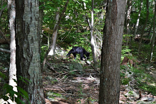
I was a little concerned with Alex, who was definitely interested in a potential new friend. Fortunately, the bear wasn't too interested in us and eventually disappeared into the woods.

Back at the car, we headed to Big Meadows for dinner. The restaurant there is dog-friendly, but it was a long line, so we ate outside from the tap room instead.

After dinner, we headed back to camp for the evening.


