
After getting our stuff together, we headed west along NV-374 and made another quick sunrise stop.

Soon we entered Death Valley National Park and crossed the state line on Daylight Pass Road.

We pulled off at the trailhead for Corkscrew Peak to enjoy our first views of the desert.

We then stopped at Hells Gate to pay admission with a view down into Death Valley.

The main road was closed here, so we took Beatty Cutoff to CA-190 and headed west to Panamint Springs. Darwin Falls Road was washed out near the start so a good thing we had the 4Runner. After parking, we set off on Darwin Falls Trail. The wash is initially dry and it didn't seem like the start of a waterfall hike.

There were some brittlebush that still had a few flowers.

The first part of the hike was desert and desert plants like creosote bush.

Some cotton top cacti were up in the cliff walls.

As there started to be some water, we saw more green plants and some sparrows.

The trail was washed out in a few places but easy to follow and a really enjoyable hike seeing the vegetation change with more water.

Soon, there was enough water that it was like a genuine creek.

There were even a few cascades along the way.

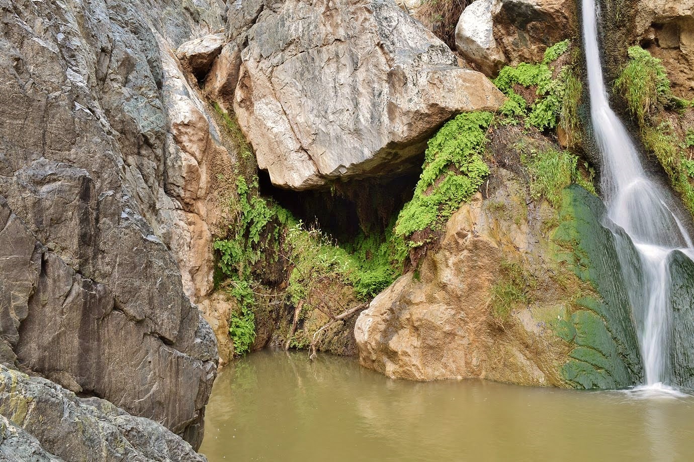
The trail ended at Darwin Falls.

Although only 18-feet high, it was really scenic and it created a beautiful oasis here. There was a thick layer of algae on the rocks near the base.

And the spray from the falls had allowed ferns and other greenery to grow.
I climbed around on the rocks to get some pictures and then we started heading back.

Although we hadn't seen anyone on the hike up, there were quite a few on the way back. Glad we got an early start.

From here, we continued west on CA-190. As the road headed up towards Rainbow Canyon, we made a stop at a scenic point.

Then we stopped at Father Crowley Vista Point for a view down into Rainbow Canyon.

Known as "Star Wars Canyon", the military used to fly fighter jets through the canyon and was one of the few places to see and photograph military jets. Due to a fatal training accident, the flights were suspended, but it was still a beautiful canyon.

From here, we headed back down the highway towards Panamint Valley and made another stop at a pretty spot.

Driving across the valley, we then headed back up towards Towne Pass. We made another stop to see the colorful mountains of the Panamint Range.

Over the pass, we headed back down and just before Stovepipe Wells, turned on Mosaic Canyon Road and drove to the trailhead. The trail entered the canyon right away and came to the first section of narrows.

The canyon is named for the breccia that is formed by smaller rocks being naturally cemented together to form a mosaic.

The canyon was really beautiful as we hiked through the narrows.

The trail passed through an open spot and curved left through more narrows.

Then we came out into a much more open and sunny section.

There was a narrow ridge that was mostly in the shade to walk along to avoid the desert sun.

There was desert holly in the canyon.

After this area, the canyon narrowed a bit and we came to the first obstacle, a boulder jam. It wasn't too difficult to crawl through on the left side to get around.


There were more narrows in this section.

The trail seemed to dead-end at a 20-foot mostly dryfall. It looked muddy and no way to climb without ropes.

Backtracking just a bit, we found a trail that went up the ridge and around the dryfall.

Continuing on, there was one more short set of narrows.

Then we came to the end, a 25-foot dry waterfall in a natural amphitheater.

I climbed around on the rocks for a nice view, but there was no reasonable way to get up and over the dryfall, so we turned around here.

On the way back, there was a cool side canyon near the end.

We saw some cotton top cactus on the hike back.

The sun was getting lower in the sky as we hiked bypassed the first dryfall and went back through the narrows.

We explored another short side canyon about half way back. It didn't go far and ended in another dryfall.

The canyon was just as beautiful on the hike back.

We hiked the ridge again through the open area for more nice views from above.

Near the end, we spotted a well-camouflaged rock wren in the canyon.

It was a popular hike but long enough to keep most people spaced out.

We hiked back through the first narrows and made it back to the parking lot.

As the sun was setting, I ran down the road a ways to get a shot of sunset.

Then we took off.

We checked into the Stovepipe Wells Inn and had dinner at the Toll Road restaurant. We also checked out the general store to get hats for the bright Death Valley sun. After dark, we headed to Mesquite Flats Sand Dunes and walked a short ways out on the dunes to view the stars. It was a little cloudy but we could see a lot of stars with almost no light pollution.
No comments:
Post a Comment