Saturday, Sandy and I took Alex for a social distancing hike along the Uwharrie Trail in Uwharrie National Forest. We left very early to arrive around sunrise. Passing the Pisgah Covered Bridge on the way, we made a quick stop.
It was still open and no one was there.
We got a few pictures of the bridge and then continued on to the Joe Moffitt Trailhead along King Mountain Road. First, we hiked up to Little Long Mountain. The open bald provides some of the best views in the Uwharrie Mountains.
No one was here yet, so we got some pictures and then headed back down. There were a lot of rocks along the trail.
Across the street, we picked up the trail to head up towards King Mountain. There were some birdsfoot violets blooming.
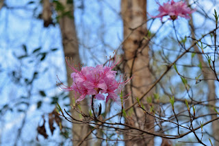
I also spotted some pinxster azaleas starting to bloom.
It was already warm and humid so the hike up was feeling strenuous. King Mountain is the highest point on the Uwharrie Trail at 1020 feet above sea level. Continuing on, the trail descended to a ridge and eventually came to a split, where left followed a yellow-blazed spur to Luther Parking. We stayed on the Uwharrie Trail and followed it to Eagles Field Road. It was really rocky as we approached the road.
This made a good turnaround point. We saw two groups on the hike back, the only other people we saw on this stretch of trail.
Saturday, March 28, 2020
Saturday, March 14, 2020
Spring Hikes at Jordan Lake
On Saturday for Pi Day, I headed to Jordan Lake for some spring hikes. My first stop was at the B. Everett Jordan Dam, parking at the tailrace area. I hiked the Lowlands and Midlands Trail down here and spotted some rue anemone blooming.
Then I picked up the connector to head towards the Visitor Assistance Center. Azure bluets were flowering in the powerline clearing.
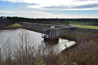
Where the trail crossed the road, I picked up the Poe Ridge Loop Trail and went right towards the visitor center. There was an overlook behind the visitor center with views of the lake and dam. Shearon Harris cooling tower was visible in the distance.
I think this overlook had some of the nicest views of Jordan Lake I've seen.
Continuing on the loop, the trail stayed real close to the lake, ducking in and out of little coves.
At the Poe Ridge Boat Ramp, I went out for another view of the lake.
The trail passes by a small pond that supports local reptile and amphibian life.
Finishing up the loop, I took the connector back down and got on the Creekside Trail.
There were a lot of eastern spring beauty blooming along the creek.
This trail ended back by the tailrace parking area.
My next stop was Ebenezer Church at Jordan Lake State Recreation Area. Parking down by the beach, I took the Connector Trail up through the picnic areas and picked up the Old Oak Trail. There were tree identification signs and an old farm pond.
Finishing up the loop, I took Connector Trail back to the beach area and got on Ebenezer Church Trail. Near where the loop split, a short spur led out to the remains of the old church for which this area is named.
It was a log cabin church so just the chimney is still standing. After the trail crossed the Boat Ramp Road, it passed by another large farm pond.
Then it looped back around and I finished up here.
I went down for a view of the lake before taking off.
My last stop was at the Seaforth Day Use Access at Jordan Lake State Recreation Area. I parked at the boat ramp and took the spur for Pond Trail to the loop. Going left the trail led to the parking for the beach area and views of the lake.
It picked up on the other side and crossed a long section of boardwalk.
There were several old farm ponds along the trail.
I went out to the osprey nest but no one was home.
The full loop was about 1.4 miles and then the short spur back to the parking.
I had worked up quite an appetite by this time and headed home.
Subscribe to:
Comments (Atom)


