Sunday, March 26, 2017

Occoneechee Mountain and Cole Mill

It was a beautiful spring day to take Alex for a hike at Occoneechee Mountain State Natural Area.  We started on the Occoneechee Mountain Loop Trail and began climbing the mountain.  Although Occoneechee is not high by any stretch of the imagination, it's high enough to feel like we're in the mountains.  A couple spots along the trail are quite rocky and reminiscent of the mountains.


The trail then leads down to Eno River.  Just beyond the park boundary is a big boulder along the river, a very scenic spot.


We continued following the trail along the river to the old quarry, where we stopped for a break.


Being a very furry husky, Alex gets hot easily.  So we climbed onto a big rock and re-hydrated.


Then we continued on to the overlook above the quarry.  It''s a steep climb up but the views are really nice here.  Looking to the west, the Eno River can be seen snaking along the mountain.


And to the east, the little town of Hillsborough can be seen.  We made a short hike up to the radio tower at the summit and then took Chestnut Oak Trail back to the parking area.  Near here, I spotted a bunch of eastern redbud blooming.


The beautiful pink flowers on these small trees put on quite a show and sometimes even grow out of the trunk.


We then headed over to the Cole Mill section of Eno River State Park.  A short drive between hikes gives Alex a chance to cool off in the air conditioning and get his energy back.  We started off on the Cole Mill Trail and followed that to Bobbitt Hole Trail and headed to the namesake drop on the river.


I took Alex down to river level to get a drink and cool off, but he was more interested in another dog who was fording the river.  I didn't have water shoes (and it was a little cold), but that might be a fun activity for Alex in the future.  From here, we made our way back to the parking lot.  There were a lot of wildflowers blooming along the trail.


The spring beauty was just about everywhere along the river bank.  I also spotted a couple patches of azure bluets.


These are the early spring wildflowers and they're around peak right now - soon more and more wildflowers will begin to bloom as spring kicks into gear.

Sunday, March 19, 2017

End of the Trail

Today, we hiked the last section section of the Mountains-to-Sea Trail through the Triangle - Pump Station to Pleasant Green in Eno River State Park.  After a rainy day yesterday, it was quite nice today, though a little cold.  We started from Pleasant Green and hiked eastbound along the Laurel Bluffs Trail to the Eno Quarry.


The water is so deep and clean, it really looked pretty today.  In the summer, it's usually full of swimmers.  Past the quarry, we took Cabe Lands Trail back to Laurel Bluffs and continued following the river downstream.  There's an old homestead here; you know you're getting close when you see the daffodils.


The chimney is about all that remains of the homestead.


One of the small tributaries to Eno River has a small waterfall.  It had rained yesterday, so it was looking nice.


And finally, we got on Pump Station to finish up the hike.  We passed the remains of the dam on Nancy Rhodes Creek.


The reservoir for the pump station was above this dam when it was in operation.  We took a break and had a snack at the Pump Station.  I spotted some trout lilies near here.


After our break, we made the hike back to Pleasant Green.  Currently, the MST continues westbound to Hillsborough following roads.


Saturday, March 18, 2017

Rainy Hikes at Jordan Lake

It was kind of a rainy day, but Alex needed a walk so I took him to the New Hope Overlook access at Jordan Lake State Recreation Area.  We hiked the New Hope Blue/Red Trail and went counterclockwise around the loop.  In a few minutes, we made it to the New Hope Overlook and took a quick break.


We continued on and got and stayed on the Red Trail at the split to do the full loop.  There were some nice views of the lake as well as a surprising amount of up and down.  We stopped at one point so Alex could take a drink from the lake.


When he was ready, we continued on and finished up the loop back at the parking lot.


Afterwards, we went for another hike on the lake.  We drove north on NC-751 to Stage Coach Road and parked along the side to hike the Eagle Spur of the American Tobacco Trail.  This trail follows the original path of the railroad - it was diverted to what is now the ATT when Jordan Lake was built.  The hike was easy except a couple spots where it looked like people were installing culverts.  We had to hike around.  At the end, the trail came to the lake.


The trail ended at the lake.  Alex was thirsty again and got a drink while I got a couple pictures.


Then we started hiking back.  We were fortunate and didn't get any rain on this part of our hike, but Alex sure did get muddy.


Sunday, March 12, 2017

Dusting of Snow on the Eno

We started our hike again this week at West Point on the Eno Park, this time hiking west, following the river upstream.  Despite the warm weather we've had this winter, it was actually snowing today.  The ground was warm so there wasn't much accumulation, but it was definitely coming down when we started.  We crossed Eno on the footbridge and turned left to follow MST westbound.  Near the dam, we had to rock-hop across Crooked Creek, but the water level was pretty low today so it was easy.


It snowed most of the way through West Point park, but there was little accumulation.  Mainly it was on spider webs.


Across Guess Road, we passed into Eno River State Park and the MST followed Laurel Bluffs Trail.  In early May, the mountain laurel along this trail put on quite a show.  The sun came out and any residual snow vanished.  We passed Gebel Rock, a nice overlook at a bend in the river.


We followed the trail to the old Durham Pump Station, where we took a break.


I walked around the ruins of this pump station that provided water to Durham at the turn of the 20th century.


It was in use until 1927 when the city needed a larger system.  It's amazing to see how nature has reclaimed the land.  One section was flooded, but a number of trees were growing out.


Even a maintenance hole had a tree growing out of it.


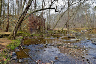
It was nice and sunny on the hike back.  What a difference a couple hours makes!  I got a couple pictures around the ruins of Guess Mill, shortly before we exited the park.


There's an old home site nearby, but only the chimney and a water pump remain.


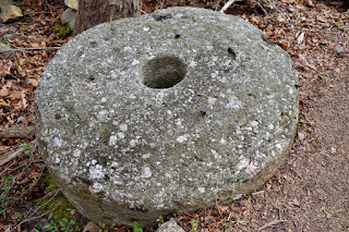
The mill stone is right next to the trail, right before it goes up to Guess Road.


From here, we passed back into West Point.  I stopped to see an old chimney along the trail.


It was still cold, but the sun was out.  One little turtle had popped out of the river onto a log to catch the sun's rays.


Soon we were back to the parking lot - just one more hike to finish up the MST in the Triangle.


Sunday, March 5, 2017

Early Spring Wildflowers on the Eno

Today we hiked the next section of Mountains-to-Sea Trail, now following the Eno River.  Although it was rather cold today, recent warm weather had caused some wildflowers to start blooming.


The starting point for our hike was West Point on the Eno and we hiked eastward to Penny's Bend Nature Preserve.  After crossing Eno River on a big metal bridge, we went under US-501 and followed the path behind some houses.  The trail crossed a bridge to a small park and then ran along a sewer easement following the river downstream.  Eventually, the trail departed from from the easement and became a more typical trail through the woods.  Like so many sections, I found a dilapidated old barn right along the trail.


Further on, we started spotting more wildflowers.  It was still early, but there were a few spring beauties and rue anemone blooming in Penny's Bend.


Our turnaround spot was the same as the week before - right by the Old Oxford Highway bridge over Eno River.  Just upstream was what little remained of Cameron's Mill - destroyed by many floods on the river.


I also spotted a number of common blue violets blooming here.


After a short break, we headed back.