Sunday, February 26, 2017

Trout Lilies and Wildflowers

Although it hit 80 yesterday, it was feeling a bit more like February today.  With a high around 50, it was quite a bit cooler, but still a great day for a hike at Falls Lake Trail.  We hiked the last section, 23 from Red Mill Road to Old Oxford Highway.  A number of small wildflowers were blooming along the trail.


After passing the campsite, I started to see some trout lilies.  These little flowers are usually the first to bloom in spring.


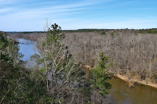
Further on, we crossed a bluff above the Eno River and came to an old abandoned railroad tracks.  We followed the tracks a short ways to a bridge over the river.


Then we finished at Old Oxford Highway and crossed to Penny's Bend and took a break at the river.  


After a short break we headed back.


Sunday, February 19, 2017

Early Spring at Falls Lake

Today, we hiked the next section of Falls Lake Trail - section 22 that starts and ends on Red Mill Road.  It was a beautiful day, feeling a lot more like spring than winter. We parked just across the bridge over Ellerbe Creek and got on the trail.  The trail follows Ellerbe Creek to the confluence with Falls Lake.  Just after a power line clearing, there's an old collapsed railroad trestle over the creek.


The trail follows the railroad tracks for a ways.  There's a neat old barn just off the trail with ivy and vines growing up.

It's made out of cinder blocks; I think that's why it's still standing.  Past here, the trail crosses a railroad spur and then runs past some fields.


All around these fields were vernal pools; many were mostly dry as we haven't had a particularly wet winter.  But we did find a few larger ones that had some little frogs in them.  One little toad was floating on a leaf.


Along another section, periwinkle wildflowers were starting to bloom.


It was really starting to feel like spring!  Section 22 ends back at Red Mill Road; we took a short break here and then hiked back.


Saturday, February 18, 2017

Small Falls at Raven Rock

Saturday, Sandy and I headed to Raven Rock State Park for a hike with Alex.  We left Raleigh and headed south to Lillington, arriving at the park before 10.  The park had suffered damage from Hurricane Matthew, but most of the trails were reopened.  We started on Campbell Creek Loop Trail, turning right after the bridge and following the creek downstream towards the confluence with Cape Fear River.  At the river, I got a couple pictures and then we continued to Lanier Falls.


Although marked as a Falls on the topo map, it's more of a rapid than a waterfall.  In fact, I've been here when the water was so high that it was completely submerged.  Still, being this far east and on the mighty Cape Fear River, it's a cool spot.


The water level was fairly high and the rocks surrounding the Falls were wet so I didn't scramble all the way out.  After a couple pictures, we continued on and finished up the loop.  Back at the visitor center, we got on the Raven Rock Loop Trail to visit the park's namesake.  We followed the trail and first made a quick stop at the overlook with great views of the Cape Fear River from above Raven Rock.


Then we hiked to the stairs and descended to the base.  It was very crowded down here on such a warm February day.  We found a spot near the octopus tree to sit and have a snack.  Alex met another husky, but he snapped at Alex.


After our snack, we headed back up and finished the loop back at the parking lot.  From here, we drove to the north side of the park to hike the West Bridle Loop.  Hiking in the counterclockwise direction, we followed the trail north towards River Road, crossing Avents Creek along the road.  Just upstream of the road was a small four-foot slide.


Across the bridge, the trail headed back to the woods and soon we came to a closed section.  This trail still isn't completely repaired after Hurricane Matthew.  Fortunately, they have a detour and we followed this to the ford on Avents Creek.  Jumping Fish Falls, a small, but surprisingly nice waterfall was just upstream of the ford.


Although only five feet high, the water level was up and it was quite photogenic.  I got pictures from both sides of the creek.


We had to ford and it was rather cold, but Alex didn't seem to mind.  From here, it was just a short hike back up to the car.  On the way home, we stopped in Fuquay-Varina for dinner at Aviator.  It's dog-friendly, so we sat outside with Alex and had some good food and beer.

Monday, February 13, 2017

Sunset over Bozeman

I spent this week in Bozeman, Montana for work.  After this past weekend with temperatures over 80 in Raleigh, it would take a bit of acclimation to get used to the Montana winter.  There were a few hiccups in Denver, but finally I made it to Bozeman.  After checking in at work, I headed over to the College M Trailhead for a sunset hike.  There's a hard way and easy way to get up to the M.  Either way, it's 850 feet of elevation gain.  The hard way goes up in 0.5 miles, while the "easy" way goes up in 1.5 miles.  With all the snow and ice on the ground, I opted for the easy way this time.  Hiking up wasn't too bad.


The trail was covered in snow, but traction was good enough in most places.  There were a couple of slick spots, but I picked up a hiking stick at the trailhead, so it wasn't too bad.  Up at the M, the views over Bozeman were great, especially nearing sunset.


I took a rest up here and got some pictures.  A couple who came up after me had a very friendly dog who I played with for a bit.  The couple was very friendly and I enjoyed talking to them for a couple minutes - the guy had just gotten back from Anchorage and the lady was from Asheville, NC.  After talking with them for a bit and getting some pictures, I headed back down.


Near the bottom, as the sun was setting behind the mountains, the sky lit up with some fantastic colors.


I got a few more pictures, then headed back.

Sunday, February 12, 2017

Planes, Trains and Automobiles

With temperatures approaching the 80s today, it was a beautiful day to hike the next sections of Falls Lake.  Today, we were hiking sections 17 through 21, starting at Hereford Road.  There had been a prescribed burn along the first part of the trail and the smell of burnt wood was still strong. The burnt areas ended after a quarter mile or so.  Near the end of this section, I stopped for a picture of the old dilapidated shack along the trail.


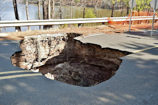
It's not in great shape and may come down soon, especially if there is another prescribed burn.  Heading to section 18, we crossed on the causeway on Redwood Road.  Sometime after Hurricane Matthew, a sinkhole opened up along the road here.


I first saw it towards the end of October and it's grown since then.  In the news, I heard someone fell in and had to be rescued by the fire department.  Next, we hiked the short section 18 to Hickory Hill boat ramp and section 19, ending on East Geer Street.


It's a surprise to see a small airstrip here and in the nice weather, some of the planes were going up.  Then we hiked along I-85 and crossed under the highway through a tunnel.


Section 20 continued to Redwood Road and Tom Clark Road and then got on 21.  Almost immediately, we crossed railroad tracks.


Then, the trail led past Holcombs Lake and a landfill before ending at Red Mill Road.  We took a break here and then hiked back. 


Sunday, February 5, 2017

Prescribed Burn at Falls Lake

Sunday, we continued hiking Falls Lake Trail.  This week, it was sections 15 and 16 from Jimmy Rogers Road to Hereford Road in Durham County.  We parked at the end of Jimmy Rogers Road at Little Rogers Road and hiked the blue-blazed spur trail down to Little Lick Creek.  We could see the boardwalk and bridge where we had ended our hike last week, but turned left on the white-blazed MST.


A short ways down the trail, we found the skull of some small animal, maybe a raccoon or possum.


Past where the trail crosses Shaw Road, there was evidence of a recent controlled burn.  All around, the ground was blackened and the smell of smoke was noticeable.  I think it had been about a week ago.  Interestingly, the trail was un-burnt and very easy to follow.


The burned area was about half-mile to a mile and then went back to normal.  Continuing on we passed the open area with the power lines and came out on Cheek Road.  Section 16 is a lot shorter and is about a mile to Hereford Road, where we turned around.


An open sunny spot made a nice spot for a lunch break.  Then we made the hike back.