Sunday, July 24, 2016

Green River Waterfalls

Sunday morning, after breaking camp, Sandy and I headed to High Falls.  Although Duke Energy was not opening the dam today, Sandy had never been and since we were so close to the trailhead, I figured we might as well stop by.  This was my first time coming in from the upper trailhead at the Pines Recreation Area.  After parking, we followed the old road down to the base of High Falls.  There are a lot of steps and it’s quite steep.


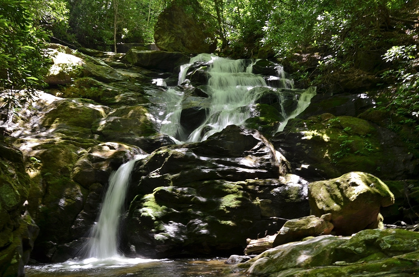
At the bottom, we stopped for a few pictures and started making our way back up.  It was very humid and so the uphill was slow going.  Above the top of High Falls, we could see First Falls upstream on the river.  We made the slow hike back to the car and then headed into Cashiers for breakfast at Bucks Coffee.  We met Badger and the others and had a relaxing breakfast and coffee, before we started making our way back home.  We got off I-26 near Saluda and followed US-176 down along the North Pacolet River.  We parked on this road in between the twin bridges over the river at the trailhead for Melrose Falls.  The trail and area around the waterfall are protected by the Pacolet Area Conservancy.  It’s a fairly easy hike to this waterfall, but the heat and humidity made it rough.  As we approached the waterfall, we climbed down to a rock outcrop overlooking the waterfall.


The view was partially obscured by trees, but the waterfall was still very scenic.  The water level was a little low, but this was definitely a nice waterfall.  After a few pictures, we made our way back.  We drove back through Saluda and followed Holbert Cove Road into Green River Game Lands.  Passing the very crowded trailhead for Bradley and Little Bradley Falls, we tried to turn right on a game land road.  But it was gated, so we parked along the road here.  It was about three-quarters of a mile to the end of the gated road.  At the end of the road, we crossed Ostin Creek and followed the remnants of an old road downstream.  The path was very overgrown and difficult to follow.  Eventually we went around a ridge and crossed a small tributary.  Past this crossing, we started bushwhacking down towards the creek to Fungi Falls.  The bushwhack was brutally steep and difficult, made that much worse by the high temperatures and humidity.  Eventually, I made it to the base of the waterfall for a picture, then started climbing back up.


It was too hot to linger.  We finished the hike back at the car and started making our way home.  We stopped in Kannapolis for Mexican at Los Arcos.

Saturday, July 23, 2016

Upper Whitewater Slot Canyon

Last weekend, Sandy and I headed to the mountains to visit the amazing Upper Whitewater Slot Canyon.  Sandy had to work Friday evening, so we left very early Saturday morning and drove out to the Ingles in Cashiers.  After meeting up with the group, we drove south on NC-107 to Heady Mountain Road and followed this to the end at the bridge over Whitewater River.  We got our stuff together and began our hike into the forest.  Shortly, we came to a dilapidated old house near the river.


Just past here, we got off the trail and started creek walking down to Nasty Falls.


We came out near the top of the waterfall and climbed down a steep rock to the base.  This small waterfall just above the slot canyon has a lot of downfall at the base giving it a nasty look, though I think the name came from the whitewater community.


Then we continued creek walking downstream to the top of Entrance Falls – the beginning of the slot canyon.


Entrance Falls is a series of cascades over pot holes as the river enters the slot canyon.  We had lunch here on the rocks at the rim of the canyon and enjoyed the amazing views.


A very steep and overgrown path led to a perch roughly in the middle of the canyon with views of the beautiful Sculpted Falls.


It was a treacherous overlook, so only stayed here long enough for some pictures, but this could be one of the most beautiful places in the world.  When we were done here, we creek-walked upstream a short ways and got on a trail that headed to the base of the slot canyon.  It was an easy trail at first, but became excessively steep at the end, requiring ropes to get down the steep sections.  The last part was really bad – we had to rappel down an almost vertical wet rock and navigate the tree branches while coming down.  Once down, we were at the base of Exit Falls, the other end of the slot canyon.


We waded and swam in the water here and got some great pictures of this waterfall.  Next, we headed up to the top of Exit Falls.  First, we had to climb through a cave near the base.  It was a little tricky rock scrambling on wet rocks in the dark.  Emerging from the cave, we were now about half-way up Exit Falls.  We had to jump up to an overhanging ledge and climb further up, then come back down to the top of Exit Falls.  Here, we swam around in the water at the slot canyon to view Little Canyon Falls, the last waterfall in the slot canyon.  To view the falls dry, I had to cross the top of Exit Falls and climb up a steep ledge for a view.


We unexpectedly ran into some other people in the slot canyon here.  They were canyoneering and were setting up rappelling gear to go down Exit Falls.  It was quite a surprise to see other people in such a remote location.  From here, we headed back down to the base of Exit Falls and follow a path downstream to Bedrock Betty Falls.


We first came out to the top of the falls, then continued on the path to the base.  We swam around in the pool at the base for a while then started making our way back.


Rather than backtracking, we followed the trail around to avoid the river and canyon on the way back.  We did stop for a little while at an old school bus along the trail.  I have no idea how it got here, but clearly hunters had been using it for target practice.   After some pictures, we headed back to the trailhead.  A few from the group headed home, while the rest of us headed to Ralph Andrews Park on Lake Glenville to camp for the evening.

Sunday, July 3, 2016

Old Fort Waterfalls

Sunday morning, I checked out of the hotel.  I was originally planning to meet friends in South Carolina for the holiday, but wasn’t feeling well, so decided to just go home.  Then Sandy and I could spend Independence Day together.  Past Asheville, I decided to stop at Catawba Falls on the way home.  I hadn’t been here in a couple years and they finally finished the bridge to the parking lot.  I could park in the lot instead of on the side of the road.  Catawba Falls is very popular so glad I got there early; there were only a few cars in the parking lot when I arrived.  From the parking lot, I set off on the Catawba Falls Trail, rock-hopping the river and then following the trail upstream.  After crossing Clover Patch Branch, I found a steep path leading down to a view of Lower Catawba Falls.


Although I’ve been here before several times, I had never been down to see this one.  Kevin Adams mentions this one is his new book.  Although overshadowed by the much larger Catawba and Upper Catawba Falls, this is a nice waterfall.  A cave to the right of the falls made a nice scene, even in the low water level.  Past here was the old dam and then I continued to the base of Catawba Falls.  The water level was low, so this waterfall was definitely not looking its best.


I got a couple pictures and then took the steep path up towards Upper Catawba Falls.


I passed a couple of people on my way up; the high temperature and humidity made the climb that much more strenuous.  By the time I got to Upper Catawba Falls, I was alone and sat and enjoyed the view for a while.


As I was heading back, I again passed the people I had seen earlier.  They had given up and were heading back.  I also spotted some bee balm along the trail.


I made it back to the car before 11 and it was a little too early to head home.  So I drove through Old Fort and parked at the Old Fort Picnic Area in Pisgah National Forest.  From here, I got on the Youngs Ridge Trail heading up towards Kitsuma Peak.  This was a really grueling hike.  It was all uphill and the heat and humidity made it just miserable.  There was almost no breeze and no creek to cool off in.  It took a while, but I made it to the summit of Kitsuma Peak.  There’s a campsite here, but too many trees for any sort of view.


Exploring around a bit, I found some cliffs just down from the summit that had a nice view west towards Black Mountain.


I relaxed here for a little while and then started making my way back.  It was mostly downhill the whole way, but still strenuous in the heat.  Back at the car, I decided to get one more waterfall before I left.  I drove east on US-70 from Old Fort and turned left on Curtis Creek Road and drove to the campground.  I got on the Hickory Branch Trail (#213), following the trail up and down a ridge to its namesake creek.  After crossing the creek twice, I got off the trail and followed a path to the base of Hickory Branch Falls.


Even in the low water, this was still a scenic waterfall.  A tree had fallen right into the middle of it, so I got to the other side of the creek for a picture.  Then I headed back to the car and started making my way home.

Saturday, July 2, 2016

High Falls Whitewater Release

Last weekend, I headed to the mountains to see High Falls on West Fork Tuckasegee. Sandy had to work, so I didn’t stay through the Independence Day holiday. I left Friday night and stayed at the Econo Lodge in Waynesville. It's a budget hotel, so nothing fancy, but the views from the room were very nice. Saturday morning, I headed towards Lake Glenville, arriving at the parking area around 9. After getting my stuff together, I started out along the path. This trail is through private property, but the landowner is nice enough to allow people to hike to the falls. The rosebay rhododendron were blooming all along the trail.


In about 1.5 miles, I made a quick detour to see Thurston Hatcher or Rough Run Falls. The waterfall is on posted private property, but it’s possible to see it from the creek.


Before the dam is opened, the water level is low enough to rock hop out into the creek and see the falls on the opposite side. It would not be possible to do this after the dam opens. After a couple pictures, I finished the hike up High Falls and found a spot to sit and wait from the opening.


As usual, it got quite crowded as it approached 10 o’clock. At around 1020, the water started. As the water level increased, the wind and mist increased and soon it was too wet for any more pictures. I headed a little further back and rested at a big rock to enjoy the view for a little longer.


A couple kayakers got in the water and started the extremely difficult paddle down the river. One flipped and was unable to roll over. Eventually he got out of his kayak and went downstream a bit before another kayaker was able to rescue him.


By 11, I was heading back to the car. I drove north back towards Cullowhee and turned right on Caney Fork Road. I was originally planning to head to the waterfalls on Sugar Creek, but the road condition wasn’t great and I didn’t know if I could make it in my Corolla. So I continued on a little further on Caney Fork Road and parked right after the road changed to gravel. I got my stuff together and backtracked a short ways on the road and turned left on Rough Butt Road, a small gravel drive. In less than a quarter-mile, the road comes to a crossing of Caney Fork. There used to be a bridge, but it washed away in a storm. I forded the creek here and continued following the old road (FSR-4669) up along a ridge over Caney Fork. Shortly, the road curved to the right and came to a crossing of Rough Butt Creek. I forded again here and climbed up a steep bank on the opposite side. There was a faint path following Rough Butt Creek upstream to the waterfall. This waterfall is not real high, but was very scenic, even in low water.


I had to wade to the opposite side of the creek for a good view of the waterfall. Then I made my way back. Back at the car, I decided to try and get Piney Mountain and Bearwallow Falls while I was here. I continued on Caney Fork Road and soon turned right on Forest Road 4666. It was almost three miles to where I would get off the trail and a grueling uphill hike almost the entire way. There was no one else out here, except for a couple of hunting dogs.


After passing the gate on FSR-4666, I got off the trail and started bushwhacking down to the confluence of Piney Mountain and Bearwallow Creeks. It was a very challenging bushwhack, and since I was alone in a very remote area, I decided to give up and head back for personal safety. Especially after my encounter with yellow jackets the weekend previous. I’ll get these two waterfalls another time when I’m not alone. Back at the car, I drove into Waynesville and had dinner at Tipping Point Tavern and then went back to the hotel. I took a quick dip in the pool before retiring for the evening.