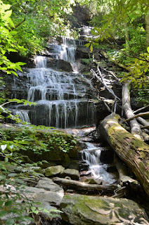
Sunday morning, after breaking camp, Sandy and I headed to High Falls.
Although Duke Energy was not opening the dam today, Sandy had never been
and since we were so close to the trailhead, I figured we might as well
stop by. This was my first time coming in from the upper trailhead at
the Pines Recreation Area. After parking, we followed the old road down
to the base of High Falls. There are a lot of steps and it’s quite
steep.
At the bottom, we stopped for a few pictures and started making
our way back up. It was very humid and so the uphill was slow going.
Above the top of High Falls, we could see First Falls upstream on the
river. We made the slow hike back to the car and then headed into
Cashiers for breakfast at Bucks Coffee. We met Badger and the others
and had a relaxing breakfast and coffee, before we started making our
way back home. We got off I-26 near Saluda and followed US-176 down
along the North Pacolet River. We parked on this road in between the
twin bridges over the river at the trailhead for Melrose Falls. The
trail and area around the waterfall are protected by the Pacolet Area
Conservancy. It’s a fairly easy hike to this waterfall, but the heat
and humidity made it rough. As we approached the waterfall, we climbed
down to a rock outcrop overlooking the waterfall.
The view was
partially obscured by trees, but the waterfall was still very scenic.
The water level was a little low, but this was definitely a nice
waterfall. After a few pictures, we made our way back. We drove back
through Saluda and followed Holbert Cove Road into Green River Game
Lands. Passing the very crowded trailhead for Bradley and Little
Bradley Falls, we tried to turn right on a game land road. But it was
gated, so we parked along the road here. It was about three-quarters of
a mile to the end of the gated road. At the end of the road, we
crossed Ostin Creek and followed the remnants of an old road
downstream. The path was very overgrown and difficult to follow.
Eventually we went around a ridge and crossed a small tributary. Past
this crossing, we started bushwhacking down towards the creek to Fungi
Falls. The bushwhack was brutally steep and difficult, made that much
worse by the high temperatures and humidity. Eventually, I made it to
the base of the waterfall for a picture, then started climbing back up.
It was too hot to linger. We finished the hike back at the car and
started making our way home. We stopped in Kannapolis for Mexican at
Los Arcos.


No comments:
Post a Comment