Hike Length: 0.2 miles
Estimated Time: < 1 hour
Difficulty: Easy
Location: Standing Indian Basin (Nantahala Ranger District of Nantahala National Forest)
Trail Users: Hiking only
Dogs: Yes
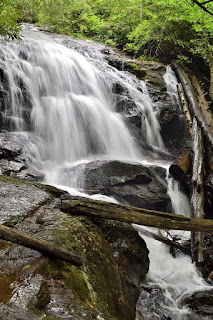
Features: Waterfalls (1)
Crowds: Moderate
Warnings: The rocks around the waterfalls are very slippery.
Trailhead GPS: 35.02902,-83.49766
Waterfall GPS: 35.02846,-83.49767
Directions:
From Franklin, head west on US-64 for 12 miles and turn left onto Old Murphy Road. Drive 1.9 miles and turn right onto Forest Road 67 towards Standing Indian Campground. Drive 7.4 miles to a pull-off on the right at the trailhead. There's a sign here for Mooney Falls.
Map:

Hike Description:
From the trailhead, follow the trail down a short ways to a split. Going left goes to the upper cascading portion of the falls.

Turn right at the split to reach the lower 20-foot drop.

Mountain laurel booms around the falls in late spring.

Here's a video of the falls.
External Links:
US Forest Service website: https://www.fs.usda.gov/recarea/nfsnc/recarea/?recid=48860
No comments:
Post a Comment