
Hike Length: 10.6 miles
Estimated Time: 6 to 8 hours
Difficulty: Difficult
Location: Greenhorn Mountain Wilderness (San Carlos Ranger District of San Isabel National Forest)
Trail Users: Hiking
Dogs: Yes
Features: Waterfalls (1)
Crowds: Low
Warnings: The rocks around the waterfalls are very slippery.
Trailhead GPS: 37.87851,-104.95799
Waterfall GPS: 37.85474,-104.98860
Directions:
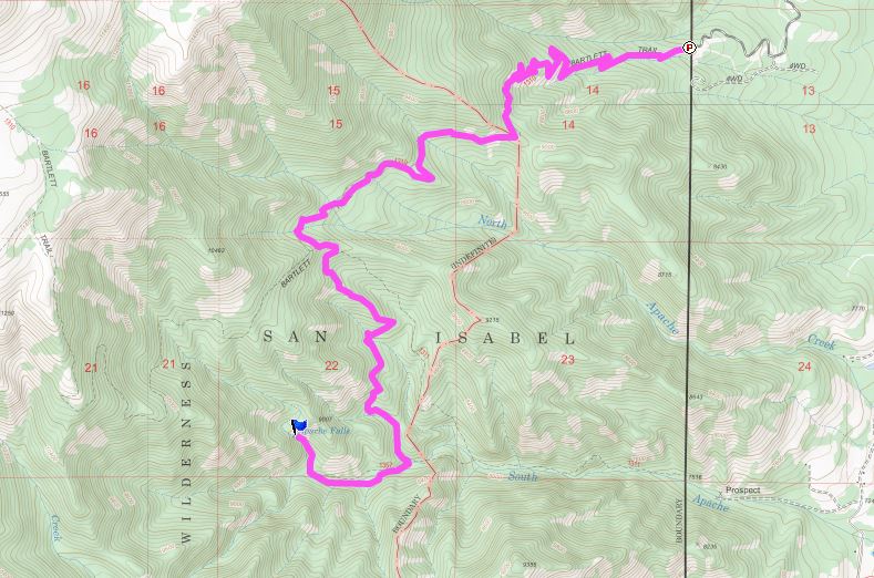
From Pueblo, head south on I-25 for about 22 miles to exit 74 towards Colorado City and Rye. Turn right on CO-165 west and go 8.2 miles to Rye. Turn left on Main Street, then left on Boulder Avenue in 0.2 miles. Go 0.6 miles and turn left on Greenhorn Drive. Follow for 1.1 miles and turn right on Baxter Avenue, which changes to gravel. In 0.6 miles, turn left on Bartlett Trail and follow for 2.8 miles to the Bartlett Trailhead parking at the end of the road.
Map:
Hike Description:
Pick up the Bartlett Trail heading up and into the wilderness. In 3.2 miles, turn left on South Apache Trail, which heads down steeply to South Apache Creek. In 1.5 miles, turn right on Apache Falls Trail and follow it upstream to the waterfall.

We visited in April and there was a spectacular "ice castle" at the base of the falls.

Here's a video of the falls.
Blog Entries:
08-Apr-2021: Apache Falls
No comments:
Post a Comment