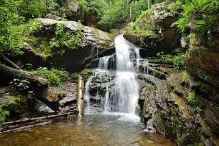
This section is mostly obscured by the foliage, but it was just a short ways to the next section.
Past here, the trail descends down to the main part and I scrambled on the rocks to see this upper section in a little grotto.
Then we went down to the main section of the falls that drops into the Blue Hole.
It was a little too chilly for swimming, but I scrambled down to the base to see the lowest section.
After enjoying the view, we headed back up to the parking lot and followed the other trail out to the cliffs above the falls. This is the only spot I know of to see more than one section at the same time, but the leaves were making the view difficult.
After some pictures, we headed back to the car.
Next, we drove to Hampton and parked at the Blueline Trailhead on US-321. The parking was nearly full and we got the last legal spot. The folks that pulled in after us parked illegally, blocking the gate, but it seems they got out before any issues. Setting off on the Hampton Blueline Trail (#501), the trail headed through powerline clearings, then entered Pond Mountain Wilderness and descended to Laurel Fork.
The gorge along the hike is really pretty and we saw some wildflowers and wildlife.
A worm snake was well camouflaged against the leaf litter.
Japanese meadowsweet is an introduced species with pretty little pink flowers.
And there were some raspberries flowering along the trail as well.
In about a mile, we got on the Appalachian Trail and continued through Laurel Fork Gorge.
There was one moderately steep part of get around some cliffs, but otherwise an easy and scenic hike. Near the waterfall, there was rock scrambling, but Alex didn't have much trouble.
At just under 2.5 miles, we came to Laurel Fork Falls, also called just Laurel Falls.
A scramble path led down to the base and we had lunch here.
It was initially crowded and some dogs were having a lot of fun playing the water. Alex doesn't like the water though, so he just took a nap.
Eventually, all the people cleared out and when we had finished lunch and pictures, we headed back too.
From here, we headed towards Erwin and got a snack and then headed down Lower Higgins Creek Road. There was no parking where the road ended, but a very rough gravel road continued into the forest. We drove to the end at the turnaround and parked, but probably would have been easier to park along the gravel road and walk the rest of the way. A gated road continued from the parking area up along Higgins Creek. In just over a half-mile, we scrambled down from the trail to see Lower Higgins Creek Falls.
The waterfall was nice and pretty high, but only the lower section was visible from the base.
After climbing back up, I went a little further upstream to see the upper sections of the falls, but there was no place I could find with a decent view.
On the hike back, we stopped at some scenic little cascades on Higgins Creek.
Then we finished up our last hike for the day.
From here, we headed to Johnson City and got dinner and checked into the Red Roof Inn for the evening.


No comments:
Post a Comment