Sunday, November 27, 2022

Color on the Millpond

Sunday, I woke up before sunrise and started breaking camp at Merchants Millpond.  It was supposed to rain and I wanted to get packed up before it started.  After finishing, I took the campground spur to the picnic area and got on Lassiter Trail.  A boardwalk crossed a scenic tributary of the millpond.


I was surprised there was still a good amount of fall color along the millpond.


I followed Lassiter Trail for a ways with a number of scenic views.


There was a new section of trail at the southern part of the loop with a spur that went out to a nice view of the millpond.


There was more nice fall color along here.


I continued on Lassiter Trail for a while until it split with the Fire Road.


I've never hiked the entire bike trail, so I stayed on this and hiked out to the parking area and around the loop.


It drizzled a bit, but never rained hard this morning.  When I finished up the loop, I headed back to the campground and took off.


Heading west, the rain picked up and was quite heavy at times, but lightened up again.  Just before Williamston, I stopped at the Kuralt Trailhead in Roanoke River National Wildlife Refuge.  The short Kuralt Trail led through a bottomland forest towards the river.


Some hairy bracket shelf fungi were growing on a log.


The trail ended where it started getting swampy towards the river.


The area was very pretty and I had gotten lucky stopping during a break in the rain.


After some pictures, I made the short hike back.

Saturday, November 26, 2022

Return to Great Dismal Swamp

Saturday morning, it was quite cold when I woke up.  After breakfast, I headed back to Dismal Swamp State Park to hike the rest of the trails on a much more pleasant day.


After crossing the bridge, I got on Supple-Jack Trail to hike through the woods and saw some beautyberry.


At the end, I got on Canal Road and saw more deer.


At the end of Canal Road, I again turned on Kim Saunders Road.


But this time, I turned on S. Martha Washington Trail to head up towards the northern boundary of the park.  Near the end were two weirs to control water flow.


The trail led over a bridge on the second one, but the first was fenced off.


At the end, I turned on Corapeake Road to hike along the park's northern boundary and state line.  Near the end, the forest opened up as I came to the location of the 2011 fire scar.


A wildfire sparked by lightning started the fire that lasted over 100 days cleared out the forest in this area.  There was a picnic table here at the northwest corner of the park where I had lunch.


Then I hiked down Forest Line Road back to Kim Saunders Road.


Hiking back, I turned to hike Western Boundary up and then back down on Laurel Trail to finish off the remaining trails I had yet to hike.


Then back to the visitor center on Canal Road.  It was a slightly shorted hike today, but still over 20 miles.


From here, I stopped at Newland Pub and Grill along US-158 for dinner then returned to camp at Merchants Millpond and made a campfire.

Friday, November 25, 2022

Rain in the Swamp

Sandy flew to Pennsylvania for the holiday and Alex was staying with his Grammy so I headed out towards the coast on Black Friday.  It was raining in Raleigh when I left but stopped for a while, then started again and was pretty heavy when I got to Dismal Swamp State Park.  There was a new floating bridge over the canal and it was cool to watch it operate.  Once across, I started hiking down Canal Road.  In about two miles, I turned on Kim Saunders Road and started hiking west across the swamp.  The rain seemed to pick up and get even heavier.  I was so wet by this point, I stopped trying to avoid puddles in the trail.  When I reached the far end, the rain had finally stopped.  I turned left on Forest Line Road to hike south.


At the end, I turned onto Bull Boulevard, which continued another 2 miles.


At one point, I saw a black bear along the trail ahead of me.  Rather than get out the camera, I tried to act big and talk loudly to alert him to my presence.  Once he saw me, he disappeared into the swamp.  I couldn't get a picture of the bear, but did get a shot of some evidence he had been there.


After around 11 miles, I decided to turn around as it was a very long hike back.  Fortunately, the rain had stopped for the day and I was drying out on the hike back.  I stopped for a break at Western Boundary Trail.


It was about 4 miles back to Canal Road from here and I was definitely counting down the miles by the time I got at this point.


A small herd of deer crossed the trail in front of me.  They seemed more curious than scared by my presence.


With just a mile to go, I stopped for a picture of the Lighter Boat Display.


And another break at the Liquor Still Replica.


Finally, I made it back to the floating bridge.  The canal was very scenic as I crossed over.


Altogether, it was almost 22 miles round trip.


From here, I headed to Gatesville and got take-out from China King then went to Merchants Millpond to eat and set up camp.  I built a small fire, but everything was wet.  Not long after the sun went down, I went to sleep.

Sunday, November 20, 2022

Chilly Hike at Raven Rock

I was gone all week in Austin for work and since Sandy had Sunday off, we took Alex for a hike to Raven Rock State Park on a very chilly morning.  We started off on the Raven Rock Loop Trail and took Fish Traps Trail down to the river.


I hopped out to the rocks, but Alex wasn't interested in getting wet.


Then we backtracked to the Raven Rock Loop Trail and stopped at the overlook for a snack.


Then we descended down the stairs to Raven Rock.


We walked as far as you can go and stopped for a snack.


I was surprised how few people were down here on a weekend.


We enjoyed walking around the base for a while and getting some pictures.


Then we climbed back up and hopped on Little Creek Loop Trail.


At the end, we took a short detour on American Beech Trail and then Longleaf Loop Trail.


And that concluded our hike.


From the park, we stopped at Aviator in Fuquay-Varina for lunch on the way home.

Sunday, November 6, 2022

Neusiok Hike

Sandy had to get back so we just went for a hike from camp on the Neusiok Trail.  The Newport River was looking scenic in the early morning light at the trailhead.


We followed the trail north as the sun began to rose.  It looked like one of the boardwalks that was crooked had been fixed since our last visit.


There were a lot spider webs for November, though after the trail crossed Mill Creek Road, it was more open.


After Alligator Tram Road, the trail got really overgrown and we only went about a mile before heading back.

Saturday, November 5, 2022

Patsy Pond

Saturday, we took Alex out to the coast for some sandy hikes.  It was surprisingly warm for November, but lovely weather otherwise.  We first headed to Patsy Pond in Croatan National Forest.  We started off on the combined trails and split from blue and green onto yellow.  A spinybacked orbweaver made his web across the trail.


As the trail looped around, we went out to Lily Pond but there was almost no water.


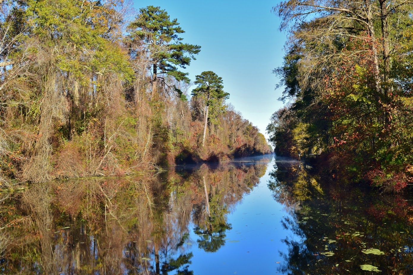
A little further, we could go out to Patsy Pond.  As the larger pond, it had some water but the level was certainly low.


Continuing on, a spur split from the main loop to run close along the pond.


Eventually, we came to where a number of sandy old roads met up and went left on an unmarked trail for a short ways.  We found a nice log to sit on and have a snack.  There were a lot of birds around here.  I was quick enough to get a shot of a myrtle warbler.


On the way back, we took the Blue Trail out to see Patsy Pond from the other side.


The Green Loop ran around the other side of Lily Pond.


Despite being late in the year, I spotted a purple gerardia flower.


We finished up the Green Trail and took the combined trail back to the trailhead.


By the time we returned, the parking lot had mostly filled up.


From here, we headed over to Atlantic Beach and Fort Macon State Park.  Parking at the fort, we started on Elliott Coues Nature Trail.  A gulf fritillary butterfly was on the ground.


There was a cool Hercules' club tree along the trail.


We then passed the Coast Guard station and hiked through a maritime forest.  Eastern baccharis was flowering.


Along the trail were nice views of the salt marsh between the island and the mainland.


The trail alternated between trail and boardwalk.


In about a mile, we went out to the marsh overlook for a short break.  It was a little warm for Alex.  Too much vegetation here for much of a view, but there were some fiddler crabs in the mud.


Sandy spotted a grasshopper on a leaf.


As we continued on the trail, a light rain started.  A huge silk spider made a web above the trail but even I could walk under without getting webbed.


We crossed the street and got on the dune portion of the trail.  Near the end was a new overlook at the ruins of a World War II bunker used to protect the coast.


There were really nice views from here with Shackleford Banks way in the distance.


Some type of yucca was growing here.


We continued on the trail, finishing up the last short section.


Some dune camphorweed was flowering.


And there was lots of sea oats helping stabilize the dunes.


Out on the beach, we found a nice spot by the inlet to sit and enjoy the waves.  Alex was interested in the little sandpipers but soon he laid down for a nap.


After enjoying the beach, we headed into town for dinner at Idle Hour.  After dinner, we took Alex for a walk on the beach.  The sun was really cool behind the clouds.


Then, we headed to Oyster Point and set up camp for the evening.  They had cleared out a lot of trees around the campsites so it was much more open than on our previous visits.  The moon was almost full and we had a nice view from our campsite.